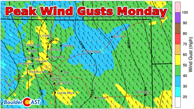
Westerly winds will quickly ramp up Monday morning with widespread gusts of 40 to 60 MPH expected across much of eastern Colorado today. While the latest model runs have indeed weakened the forecasted winds somewhat, fire danger will definitely be elevated through the day. We review the latest model data and provide an update on how the high winds, Mountain snow, and fire risk will unfold on Monday.
NOTE: Due to the ongoing weather event, our usual weekly outlook forecast will be posted on Tuesday this week. Check back then for a broader outlook of the next five days.
This content is for BoulderCAST Premium members only. Join Premium now to get access to our detailed forecast discussions for Boulder and Denver every single day, plus a bunch of other cool perks!
Daily Forecast Updates
Get our daily forecast discussion every morning delivered to your inbox.
All Our Model Data
Access to all our Colorado-centric high-resolution weather model graphics. Seriously — every one!
Ski & Hiking Forecasts
6-day forecasts for all the Colorado ski resorts, plus more than 120 hiking trails, including every 14er.
Smoke Forecasts
Wildfire smoke concentration predictions up to 72 hours into the future.
Exclusive Content
Weekend outlooks every Thursday, bonus storm updates, historical data and much more!
No Advertisements
Enjoy ad-free viewing on the entire site.


Thank you for slowing the fear. People are activated on the anniversary of the Marshall fire. Trauma therapist here. I know the patterns. Thanks again.
Still is definitely fire danger today that cannot be ignored, but it’s not a burn down an entire town kind of day. Let’s just hope we dont see any smoke plumes…