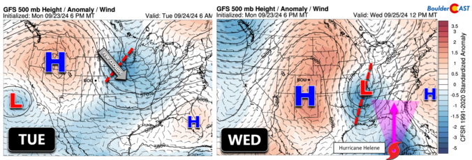
An overnight shortwave has dropped south out of Canada and into the Upper Midwest with a stream of clouds pushing into the Front Range from the northeast. The nighttime microphysics satellite animation from GOES-East is shown below. Most of the thick lower clouds (white shadings) are remaining well off to our northeast. Only an influx of spotty cirrus clouds (dark …
Ben grew up in southwestern Pennsylvania and holds both a bachelor's and a master's degree in Meteorology, the latter being from CU Boulder. His hometown received nearly three feet of snow from the Storm of the Century back in March of 1993, sparking his initial interest in impactful weather. Ben currently works on remote sensing and data analysis software at NV5 Geospatial Software in Boulder.