After a mild and gorgeous weekend, the week ahead continues on the same note, at least to start! Colder temperatures and a good threat for rain/snow arrives late Wednesday into Thursday. Uncertainty remains on where snowfall will be greatest, but likely favors the higher elevations of the Front Range due to the marginal temperatures. Sunshine and warmth return for the upcoming weekend.
This week’s highlights include:
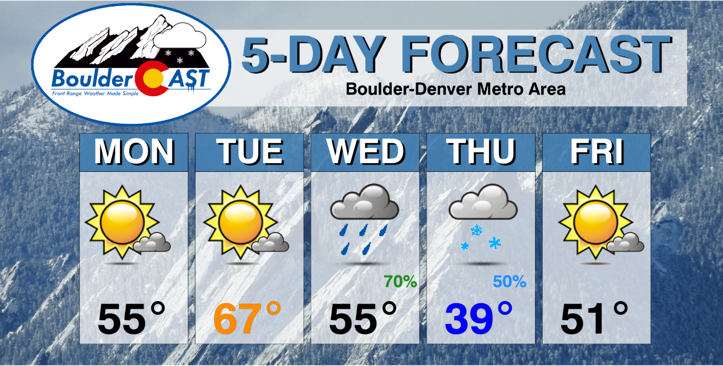
- Sunny but slightly cooler than normal Monday in the middle 50s
- Warmth returns Tuesday with highs well into the 60s
- A Pacific trough will impact the area Wednesday into Thursday with rain transitioning to snow across the area
- Snowfall totals still uncertain at this stage, but favor the higher terrain along the Front Range due to marginal temperatures and upslope direction
- Staying chilly on Friday, but we’ll warm up nicely for the weekend ahead
DISCLAIMER: This weekly outlook forecast is created Monday morning and covers the entire upcoming week. Accuracy will decrease as the week progresses as this post is NOT updated. To receive daily updated forecasts from our team, among many other perks, subscribe to BoulderCAST Premium.
Dry and mild to start
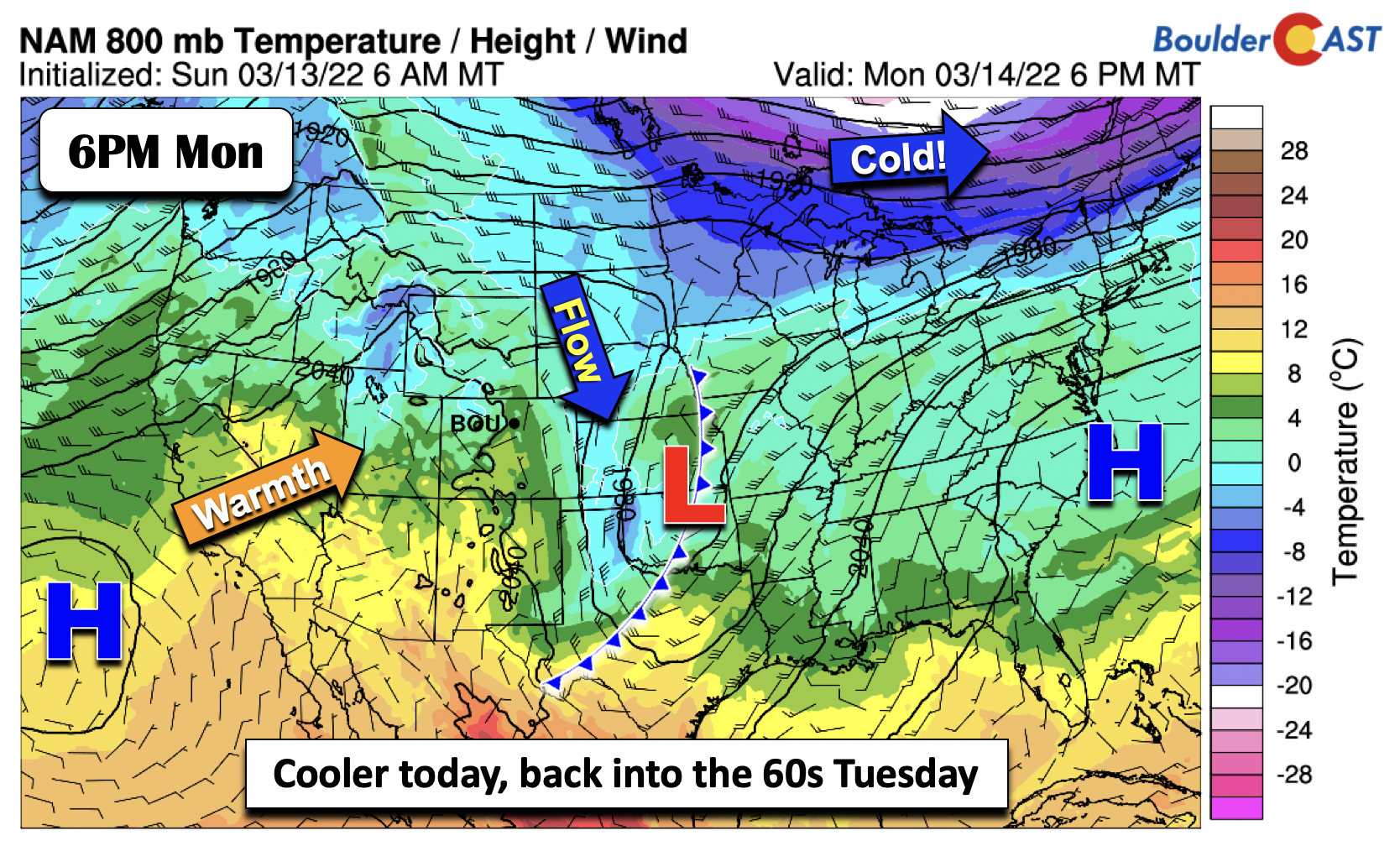
What a pleasant and warm weekend it was across the Denver Metro. Highs on Sunday ended the weekend in the middle 60s. Last night’s trough and cold front have pushed into the central Plains and Midwest today. Northerly flow remains over the Front Range this afternoon on the back side of the system. Cooler temperatures will thus be the norm on Monday but only slightly below average in the middle 50s.
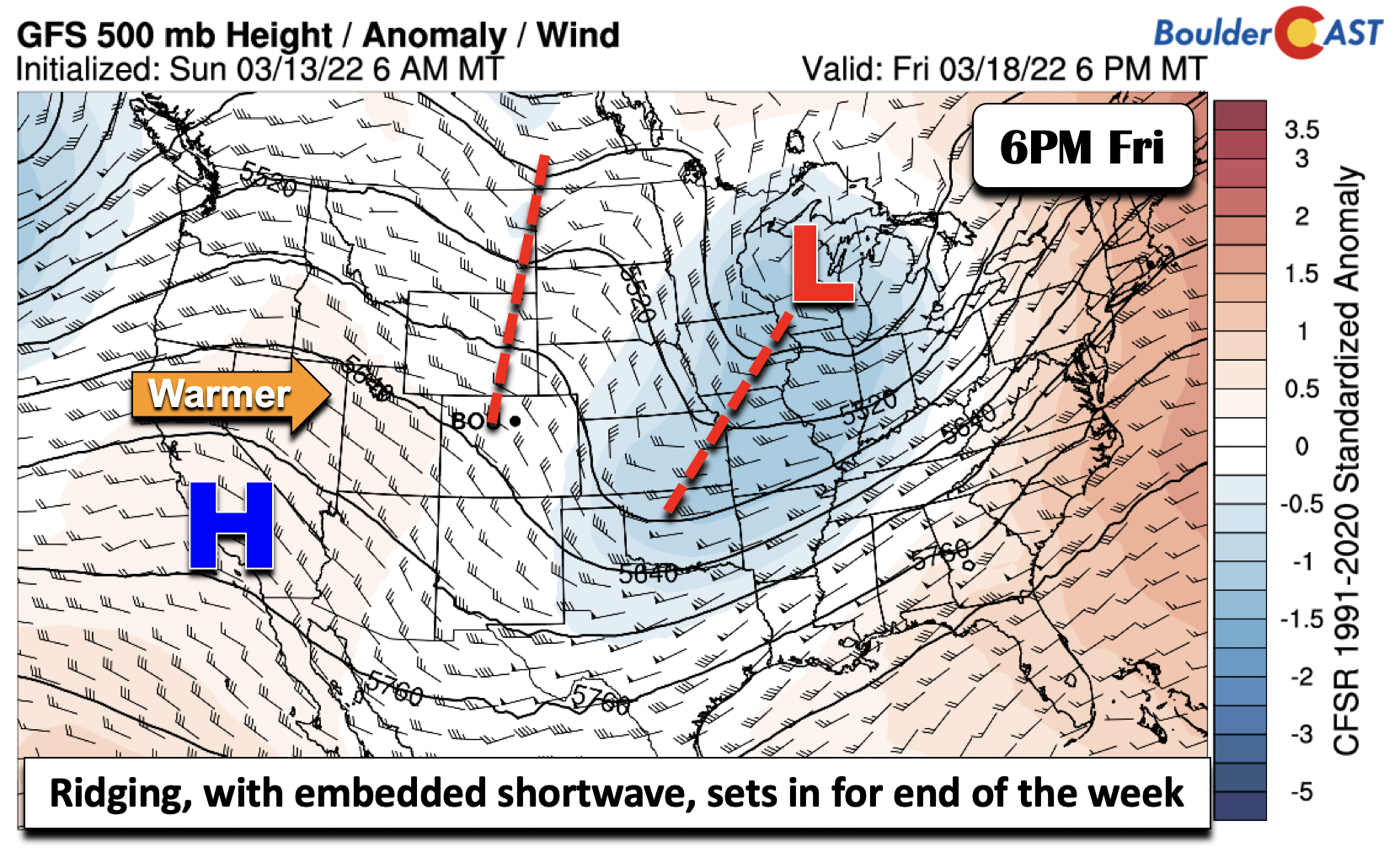
The above figure also shows warmer weather over the Desert Southwest and portions of southern California. This warmth — in all its glory — will build back into Colorado tomorrow as a ridge pushes in from the west. We will easily soar into the upper 60s on Tuesday with only partial cloudiness.
Potential potent winter storm by midweek
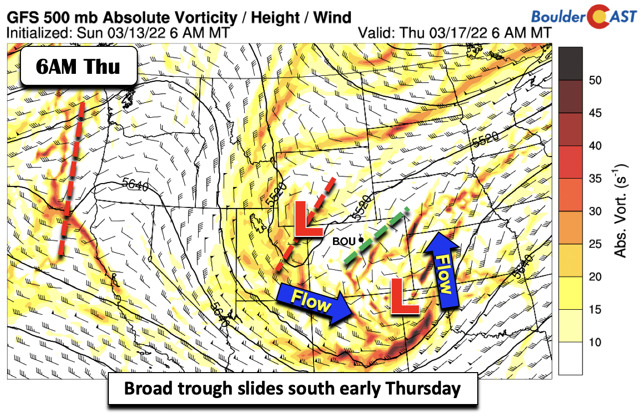
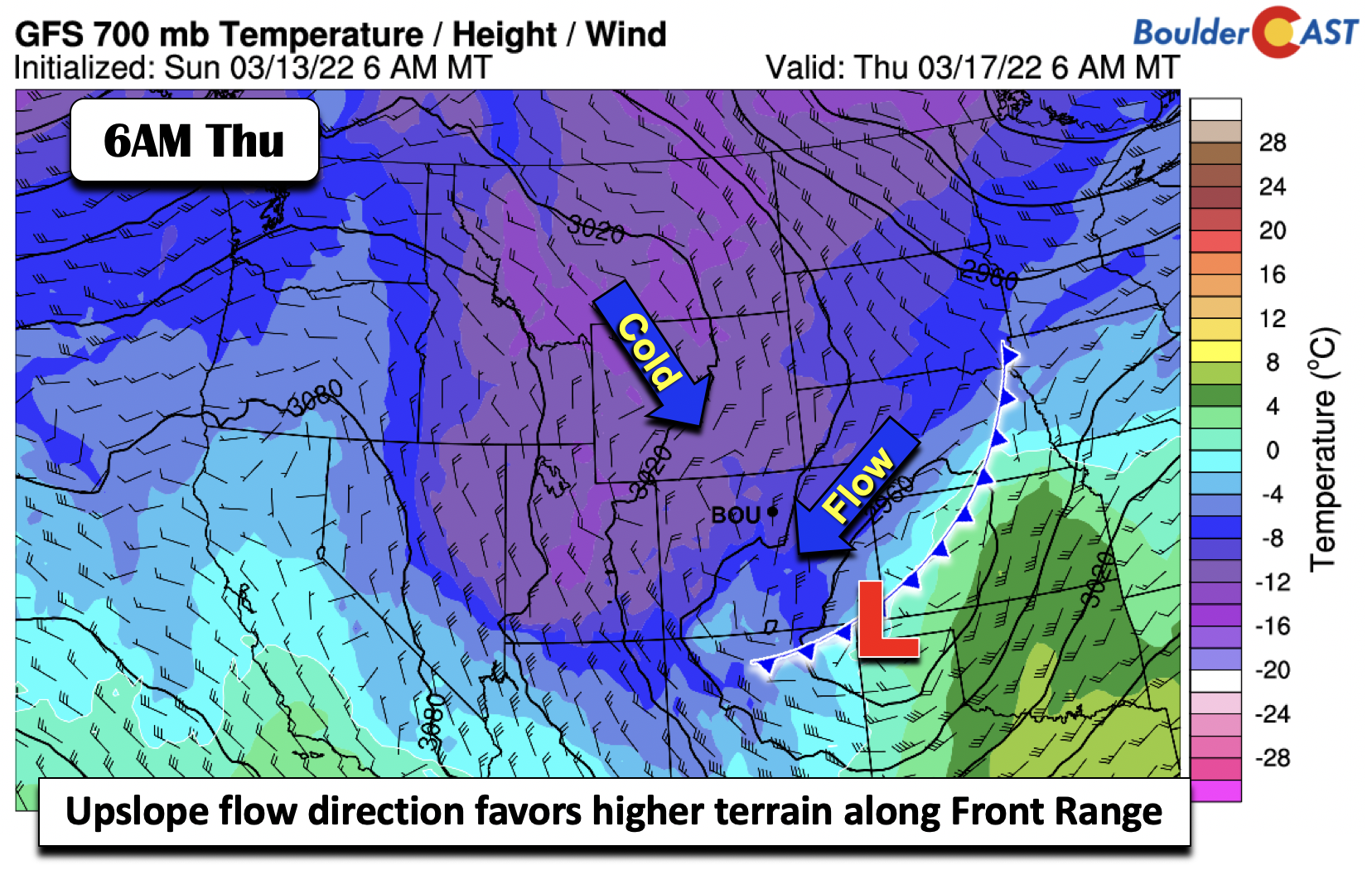
The forecast for the latter part of the week largely focuses on one mid-level trough poised to take a southeastward track from the Pacific Northwest into Colorado Thursday morning, moving out Thursday night to early Friday. The system is still offshore and won’t move inland until Tuesday. The operational GFS below shows the potential location of the trough by 6 AM Thursday. The trough is rather large, with rather broad lift, as opposed to strong and focused lift sometimes seen. This is just one model solution. As we’ll discuss below, there is uncertainty on its exact position/track given this broad nature. Due to that, we’ll discuss ensemble guidance to give you a probabilistic forecast for now.
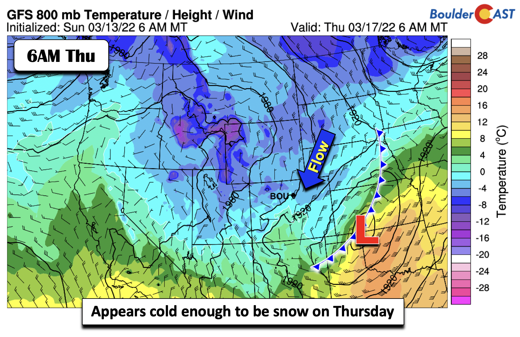
What is more certain is that it appears cold enough to transition to snow as the airmass cools well below freezing both at the surface and aloft. At 5000 feet up, temperatures drop to around -10°C Wednesday night. The GFS track shows a low forming near the Texas Panhandle, placing the Front Range in a stiff north-northeasterly flow. A slight deviation would alter where the strongest upslope may form. As it stands in the GFS, it would favor the southwestern Denver suburbs and Foothills, as well as the Palmer Divide.
Further down at the surface, the GFS early Thursday shows the surface low over western Oklahoma. Northeasterly winds are rather brisk, with temperatures around -2°C. The is just cold enough for all snow by this time, but the airmass is initially warm enough to support rainfall Wednesday afternoon and evening. The flow here would favor Boulder and far southern Denver.
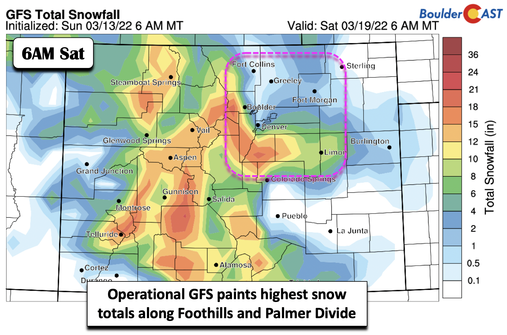
Before going into the ensembles, lastly we show the GFS model-derived snow accumulation. Based on what we discussed, it’s no surprise that the highest snow totals are painted along western Metro, the Foothills, and along the Palmer Divide, with little in between Boulder and Denver. Why would this be? The northeast flow transitioning to northerly winds would favor a broad period of upslope at these two elevated areas. Although there could be some jet forcing, outside of the mid-level trough, there is little additional deep lift to promote higher amounts further east in central Denver. Temperatures are playing a role here as well with the early part of the event, the time when precipitation could be most intense, likely being rain or a rain/snow mix in the Denver Metro area. Again, this is but one data point from a single model.
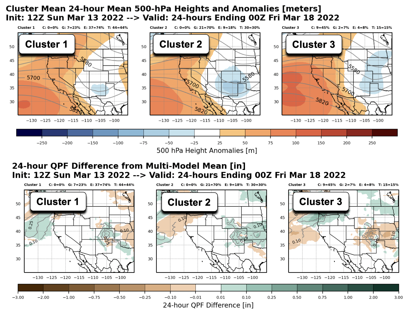
Let’s take a look at a suite of ensemble products, which will give us more confidence. NOAA recently developed a new product to look at a suite of 3 different ensemble systems, the GEFS, the Canadian ensemble, and the ECMWF ensemble. The product combines all 3, taking into account a total of 100 members, or 100 possible model solutions. To show the data, the output is organized by a series of “clusters” which aggregates the data based on the top four similar patterns. The images below show the top three clusters of solutions for 500 mb height anomalies and precipitation (relative to the mean; green denotes higher precipitation relative to the ensemble mean). The time is for Thursday evening. The first two clusters of solutions show the broad trough similar in the GFS, though vary in its depth and timing. The trough may be slightly separated from the flow to the north. These first two clusters account for 74% of the ensemble data. The precipitation plots in the first two clusters indicate that with the trough position, precipitation would be higher than the ensemble mean over the Front Range, consistent with the GFS. Cluster 3, while similar, is drier, but largely because it is faster in its eastward progression at this time.
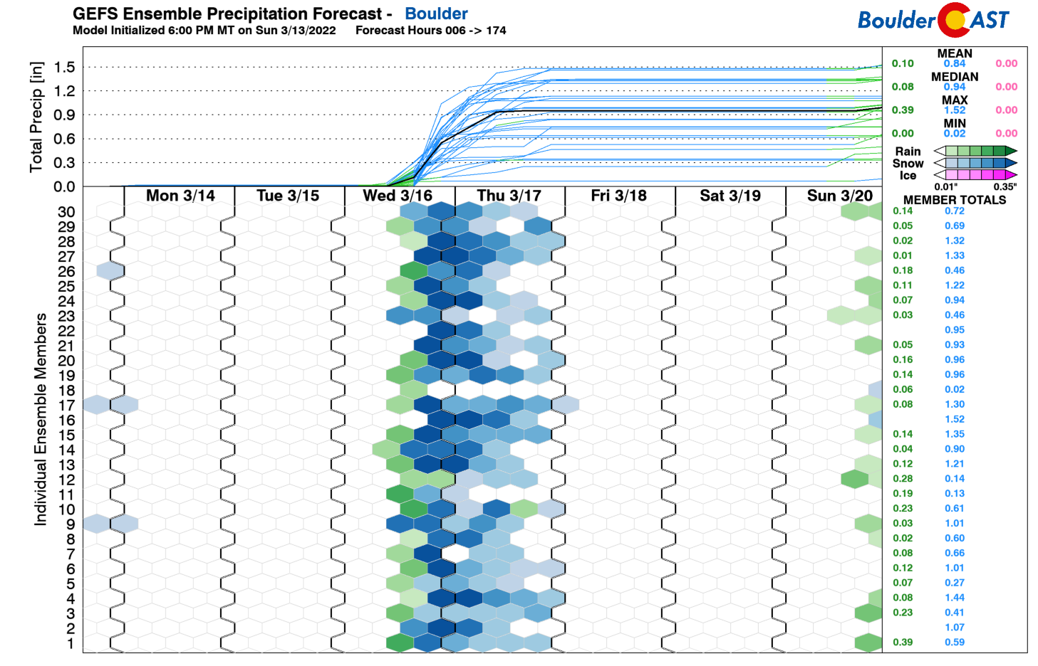
Looking at our in-house GEFS precipitation plume for Boulder, there is near certainty that it will snow late Wednesday night and Thursday, with a likely rain/snow mix at the onset Wednesday afternoon and evening. The GEFS mean precipitation shows almost 1 inch of liquid by late Thursday. If temperatures can cool fast enough, that could lead to nearly a foot of snow, assuming a simple 10:1 snow-to-liquid ratio.
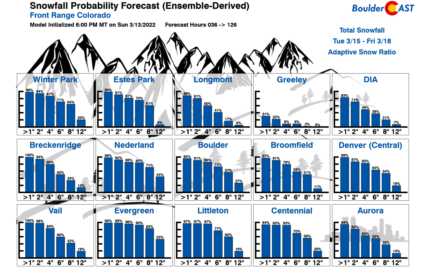
Our snowfall probabilities show that there is a 73% (64%) chance of 6+” in Boulder (Denver). Probabilities are lower at 8″ or greater, roughly 57% in Boulder and 54% in Denver.
To sum things up for the midweek period:
- Highs cooler Wednesday behind a pre-trough front: Highs will cool off to the middle 50s Wednesday, but could be colder if the cooler airmass moves in faster than anticipated.
- Rain/snow to snow late Wednesday to Thursday: As the trough digs southeast, colder air will slowly ooze south into the Plains. Rain is likely for the onset across the Denver Metro, but will change to all snow Wednesday night into early Thursday as the airmass drops entirely below freezing. The change-over timing will be critical. Highs Thursday largely in the upper 30s.
- Snowfall amounts uncertain: There is high confidence shown by a large suite of ensemble data that snow will occur Wednesday night into Thursday for everyone. Amounts, however, are uncertain and will largely depend on how the trough evolves as it tracks southeast through the area. The track will control the most favored upslope regions. Although the ensembles are bullish on snow amounts, there could be wide variations in snow totals due to forcing largely driven by upslope flow, which the ensembles may not pick up on due to their lower resolution. Jet forcing and mid-level vorticity advection could play a larger role if the storm trends stronger — perhaps this is seen in ensemble data. All of the Plains will see some snow, but the potential exists for a significant snow event for areas in and near the Foothills and Palmer Divide, especially for those spots above 6500 feet elevation.
Warming and drying to end the week and start the weekend
Most of the ensemble and deterministic data at this point indicate that our snowstorm will exit to the east into the Great Lakes and Midwest by Friday. Zonal flow will develop, with a weak subtle shortwave embedded in the flow. Highs will still be below normal but should rise close to the 50-degree mark.
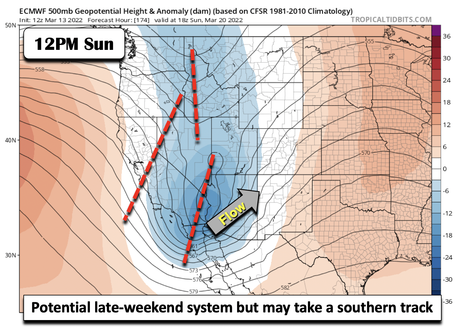
Over the weekend, ridging appears favored, with highs potentially returning into the 70s! There are some hints that another storm system may push into the area by late Sunday. The GFS/ECMWF take a southern track with this storm, largely sparing the area. For now, we’ll keep the weekend dry with just above average temperatures expected.
Have a good week and think snow, if you fancy more of it!
Fun fact: Just an average amount of snowfall the rest of the season will put Boulder close to hitting 100" for the THIRD winter in a row! That's never happened before… #COwx #Boulder #Boulderwx pic.twitter.com/M2skPHs6gW
— BoulderCAST Weather (@BoulderCAST) March 14, 2022
Stay up to date with Colorado weather and get notified of our latest forecasts and storm updates:
Forecast Specifics:
Monday: Mostly sunny and cooler with highs in the middle 50s on the Plains and middle 40s in the Foothills.
Tuesday: Partly to mostly sunny and much warmer with upper 60s for the Plains and middle 50s in the Foothills.
Wednesday: Turning cooler with highs in the low to middle 50s on the Plains and low to middle 40s in the Foothills. Rain is likely Wednesday evening changing over to snow late.
Thursday: Snow likely with highs in the upper 30s on the Plains and upper 20s in the Foothills. Snow could mix with some rain during the day. Snowfall totals uncertain but highest over the Foothills and Palmer Divide, with several inches possible on the Plains as well.
Friday: Mostly sunny and warmer but still below average with highs near 50 on the Plains and upper 30s in the Foothills.
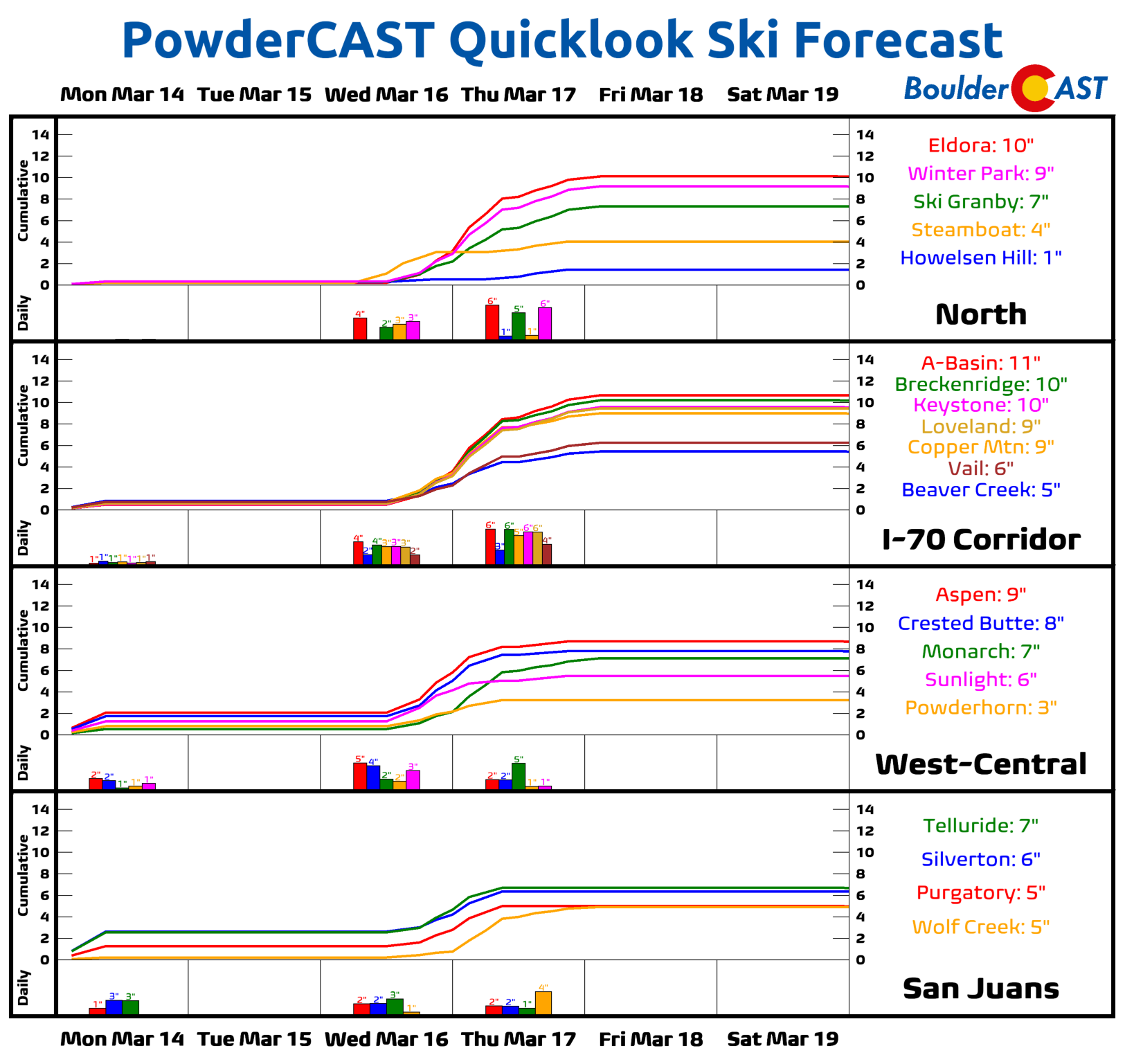
Mountains: Quiet weather is expected Monday through Tuesday with rather sunny conditions. Unsettled weather in the form or rain/snow is expected Wednesday night, becoming all snow Thursday, especially along the central and southern sections of the High Country. Some ski resorts could pick up 5-10″ of new snow this week. Warmer and drier weather returns for the weekend ahead.
Help support our team of Front Range weather bloggers by joining BoulderCAST Premium. We talk Boulder and Denver weather every single day. Sign up now to get access to our daily forecast discussions each morning, complete six-day skiing and hiking forecasts powered by machine learning, first-class access to all our Colorado-centric high-resolution weather graphics, bonus storm updates and much more! Or not, we just appreciate your readership!
Spread the word, share the BoulderCAST forecast!




You must be logged in to post a comment.