The week starts off mild but slowly turns colder along with a chance of late-week snow. We discuss all of this, as well as the continued snow for the Mountains to our west.
Mild to start, clouds on increase
What a gorgeous weekend it was across the state! Both Saturday and Sunday had highs in the 40’s under sunny conditions in the Boulder area. This of course came after a very active Friday which at times offered ominous looking skies, some rain drops, 50+ MPH wind gusts, and even a few isolated January thunderstorms across the Denver Metro area.
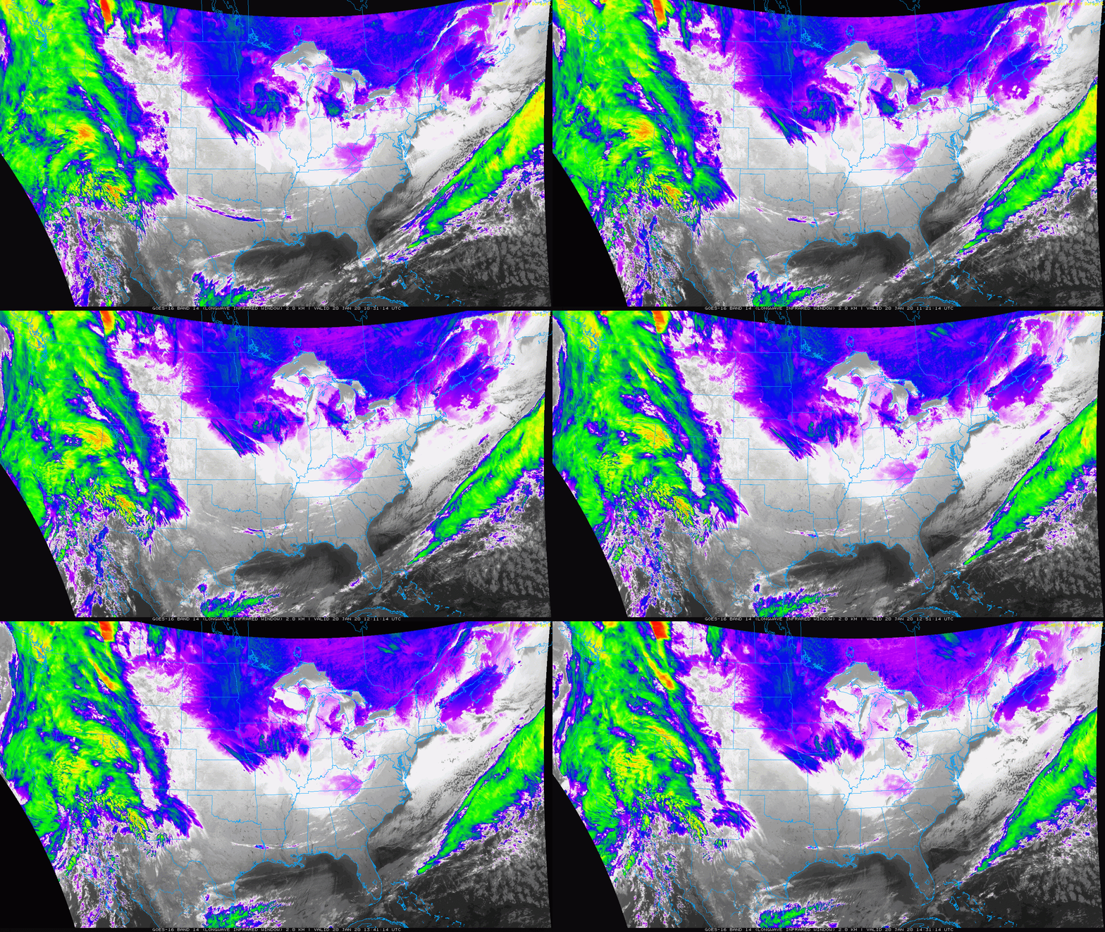
The below satellite animation shows the infrared picture as of Monday morning. While much of the Midwest and eastern U.S. are quiet, a system lurks out in the eastern Pacific. Take note of the large conglomeration of high clouds pushing into western Colorado and much of the West. While we will start off sunny today, clouds will be building late today and actually stick around for much of the week thereafter.
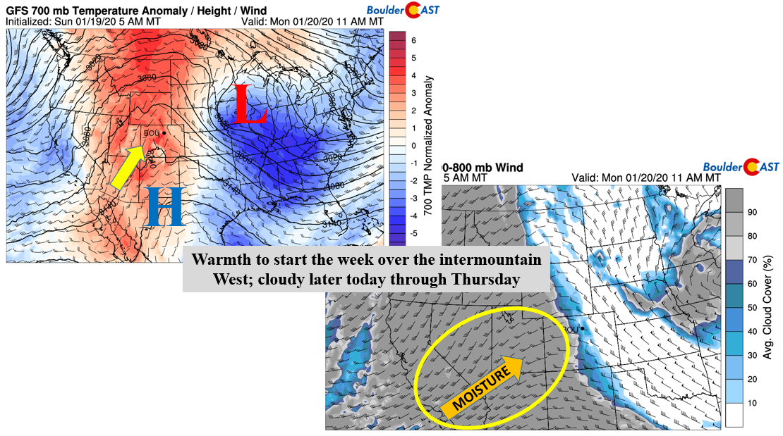
Highs this afternoon rise further from yesterday into the lower 50’s. This warmth is not just over Colorado. As evident below (left side), the warmth extends from western Mexico into Canada (red shading). Only the Midwest and parts of the southeast are on the chilly side for late January. Expect high clouds to work in for the late afternoon/early evening hours thanks to a deep trough penetrating into the state (below right). This system won’t really affect us until tomorrow but it has a lot of moisture embedded with it, some of which is subtropical.
Mountain snow Tuesday
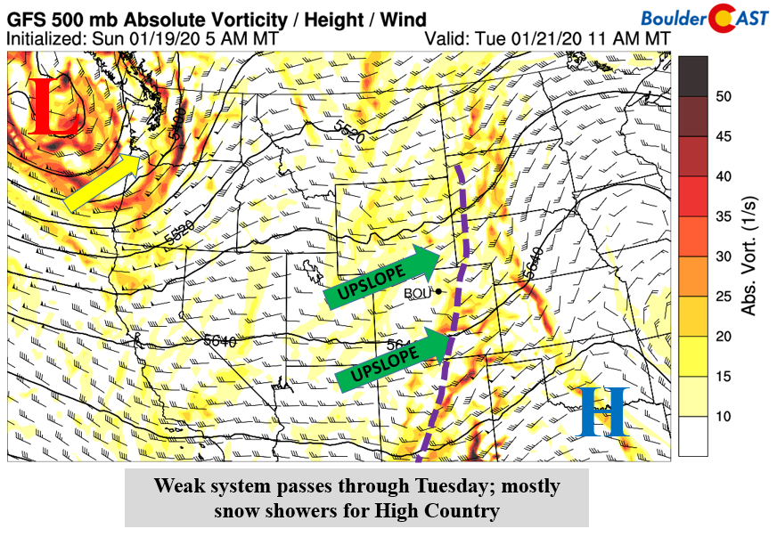
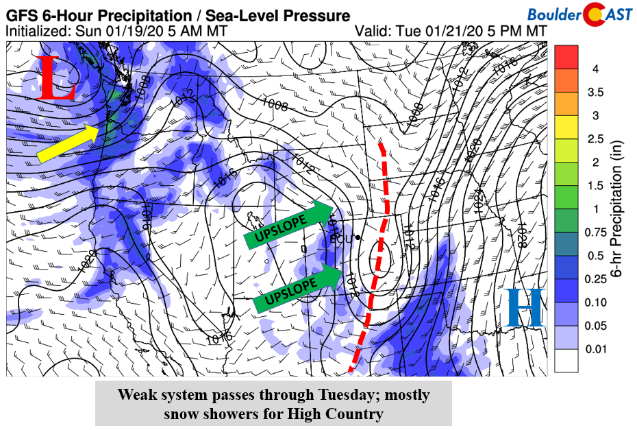
On Tuesday, the trough system pushes across the state. It is actually quite a weak disturbance. Its only signature of being a storm is the weak trough axis from South Dakota, through Colorado, and into New Mexico, along with a few ripples of vorticity (circulation for lift). The effect for us on the Plains will largely just be increased cloud cover through much of Tuesday across the mid and upper-levels of the atmosphere.
However, the High Country and ski resorts will see a different picture. Due to the nature of this system bringing in above average moisture content, the west to east oriented track of the storm will facilitate upslope conditions along and west of the Divide. That will lead to a period of light to moderate snow showers for the mountains (below) for Tuesday into the early part of Wednesday. This will be the first in a series of snowy systems to affect the higher terrain, producing 1 to 4″ of new snow. Tuesday’s highs with the clouds over the Plains will still remain in the lower 50’s.
Late week snow chances and turning colder
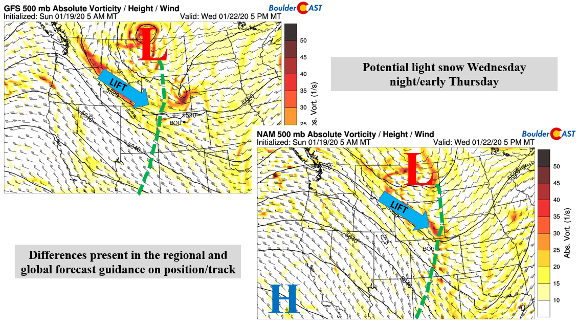
Starting on Wednesday, the pattern begins to shift. However, there are some differences in the regional and global forecast model guidance. The mid-level 500 mb absolute vorticity and height is shown below for the GFS (left) and NAM (right) models for Wednesday evening. Both models show a low pressure centered over central or eastern Montana. However, differences take shape south of the system. The NAM is a tad faster than the GFS and also further north with the embedded shortwave energy. It places much of the lift over Wyoming and largely “misses” the Front Range. The GFS, has a more southern track to the embedded waves of energy, thus placing the Front Range is a potential chance for snow Wednesday night into early Thursday. We’ll nevertheless start out Wednesday again mild in the 50’s, but turn colder for the evening and Thursday.
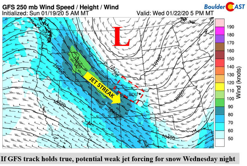
If the GFS model track and timing verify, and/or if the system takes a more southern development, it will increase our snow threat. But for now, we’ll say a 30% chance of snow Wednesday night into early Thursday. The GFS, if verifies, may lead to some jet-forced lift with the wave. A jet streak positioned from Idaho into Colorado may favor lift in the northeast part of Colorado which will be something to watch.
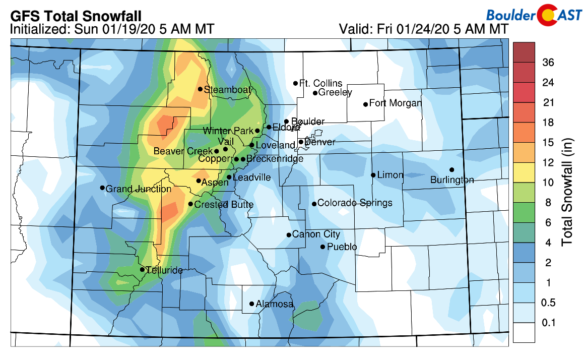
Overall, much of this week’s snow will be found in the higher terrain (below). With the first wave of snow Tuesday, and a second Wednesday/Thursday, the mountains to our west will likely pile up 5 to 12″ of snow. As for the Plains (below), a trace at best is expected. So yes, unfortunately it’s going to be a another rather dry week.
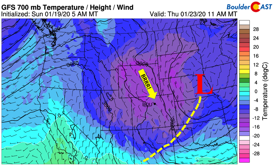
Following Wednesday’s storm system passage, a cold front will dip our highs to end the week Thursday and Friday into the low and middle 40’s. Temperatures ~5000 feet up will drop well below freezing. This will spell out a cold end to the week, but certainly nothing extreme.
We’ve received a lot of emails and comments about the lack of snow for the last six or more weeks in our area. Current trends looking ahead don’t show many prospects, at least through this weekend with another ridge expected to build in. Long-range climate models and predictions show our area turning wetter during the Spring season (March through May)! However, the skill in the these forecasts are typically fairly low in the absence of a La Niña or El Niño, as is the case right now. We are definitely overdue for the white stuff!
Forecast Specifics:
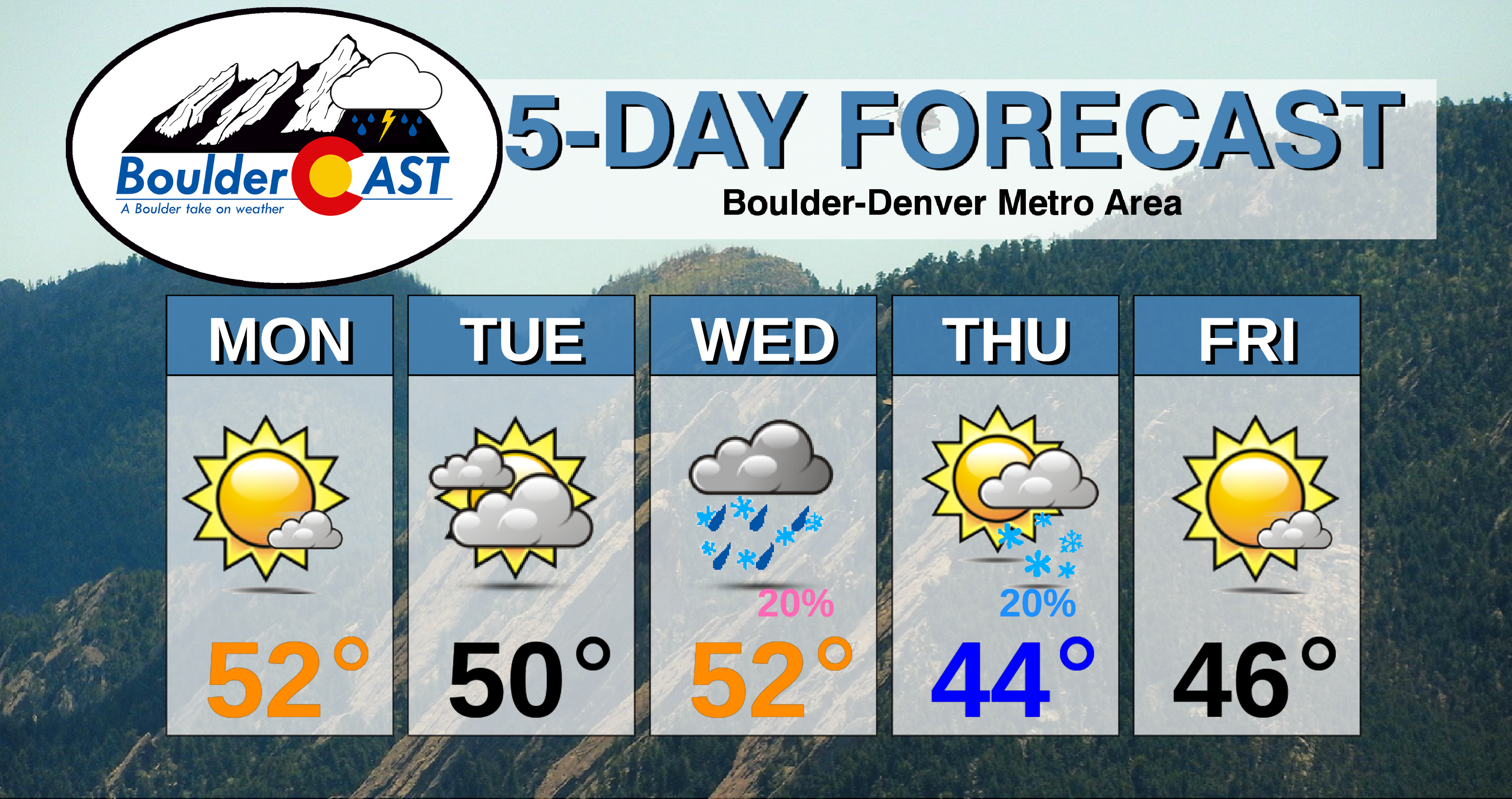
Monday: Mostly sunny skies giving way to increasing high clouds in the late afternoon. Highs in the lower 50’s for the Plains and lower 40’s in the Foothills.
Tuesday: Mostly cloudy skies and still mild with highs in the lower to middle 50’s on the Plains and lower 40’s in the Foothills.
Wednesday: Partly sunny skies with highs in the low to middle 50’s to start for the Plains, then colder in the late evening. A slight chance of rain showers in the daytime and snow showers after sunset exists. No accumulation expected. Winds could be gusty overnight.
Thursday: Mostly cloudy turning sunnier with a small chance of light snow showers early. Highs in the lower 40’s for the Plains and low 30’s in the Foothills.
Friday: More sunshine but still chilly. Highs in the middle 40’s for the Plains and lower 30’s in the Foothills.
High Country: After a calm start to the week, snow showers push in for Tuesday, as well as Wednesday night and Thursday. A total of 6-12″ is possible for many of the ski resorts by the time the week ends, especially the northern resorts. The weather turns more pleasant to end the week on Friday with sunshine expected. Check our PowderCAST page for always-updated weather forecasts for all of Colorado ski resorts.
DISCLAIMER: This weekly outlook forecast is created Monday morning and covers the entire upcoming week. Accuracy will decrease as the week progresses as this post is NOT updated. To receive daily updated forecasts from our team, subscribe to BoulderCAST Premium.
.
Spread the word, share our forecast!




You must be logged in to post a comment.