A milder week is expected, but there is still plenty of snow on the ground to hamper our warm-up. We detail how warm we may get, along with the threat of gusty winds, light snow/rain showers, and what skiers can expect for the week ahead. Read on for more details.
Warmer but still a chill in the air to start…Windy tonight?
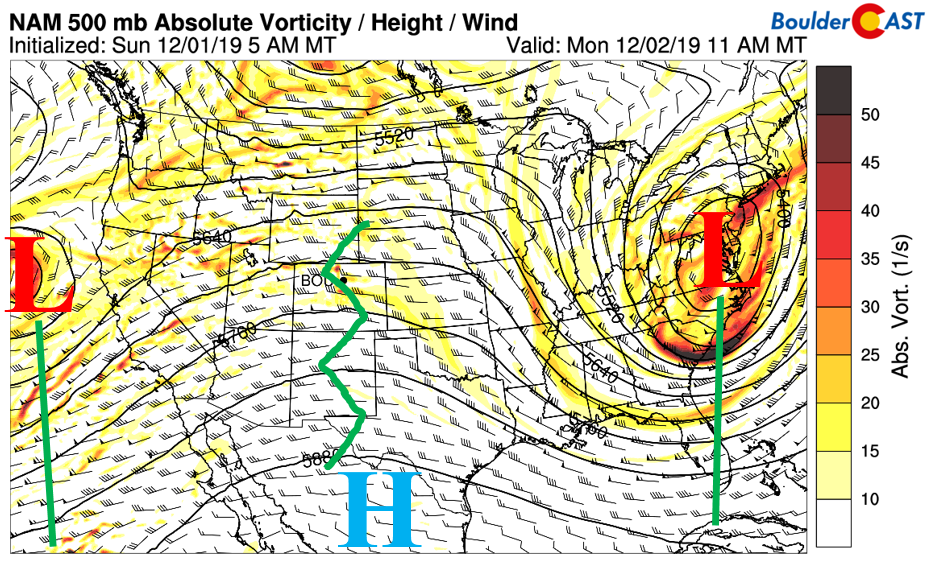
We hope you all had a wonderful Thanksgiving holiday. Welcome to December! We start out the week on a calm and slightly warmer feeling, albeit with that chill still in the air from the snow cover. The nation’s weather is shown below in the 500 mb absolute vorticity map from the GFS model. A deep trough exists out east over Virginia, with snow advisories/warnings out the wazoo. High pressure sits over Colorado, with yet another system looming off the coast of California (our player for Wednesday).
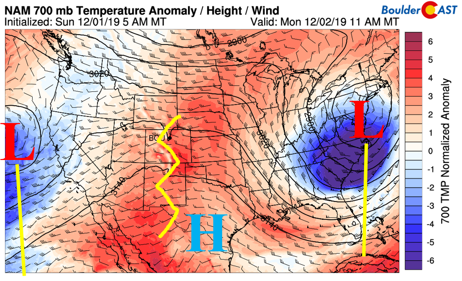
Under this atmospheric flow pattern, the airmass (below) is cold as expected across the East Coast, warm in the Rockies and Great Plains, and cool out in the Pacific. Normally, under this flow regime, we’d see a nice warm-up for Denver and the Front Range thanks to the anomalously warm temperatures under the ridge and downslope winds. However, with deep snow cover remaining on the ground, things are a little bit more complicated.
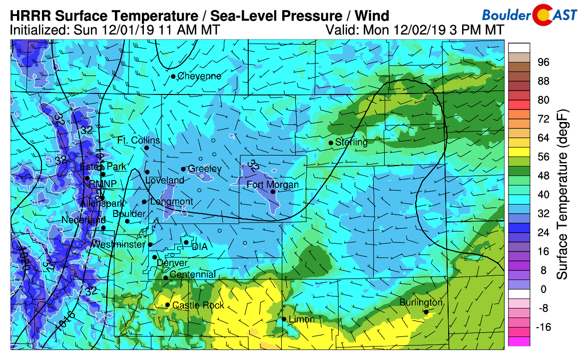
As we have seen much of this past holiday weekend, temperatures have struggled to rise above freezing, or even out of the middle 20’s for that matter. Deep snow cover still remains for much of the area thanks to last week’s potent storm system that dumped 1 to 3 feet of snow across the region. As a result, much of the sun’s energy today will go into melting the snow and/or get reflected back to space. Warm air advection and slight downsloping though will help our temperatures reach their warmest since last Sunday: the upper 30’s to near 40 this afternoon (below). Places further south will easily get into the 40’s to lower 50’s. The amount of warming will depend on how fast the downslope winds kick in. We should also see some wave clouds this afternoon, reducing the amount of actual sunshine.
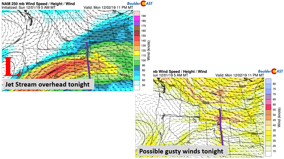
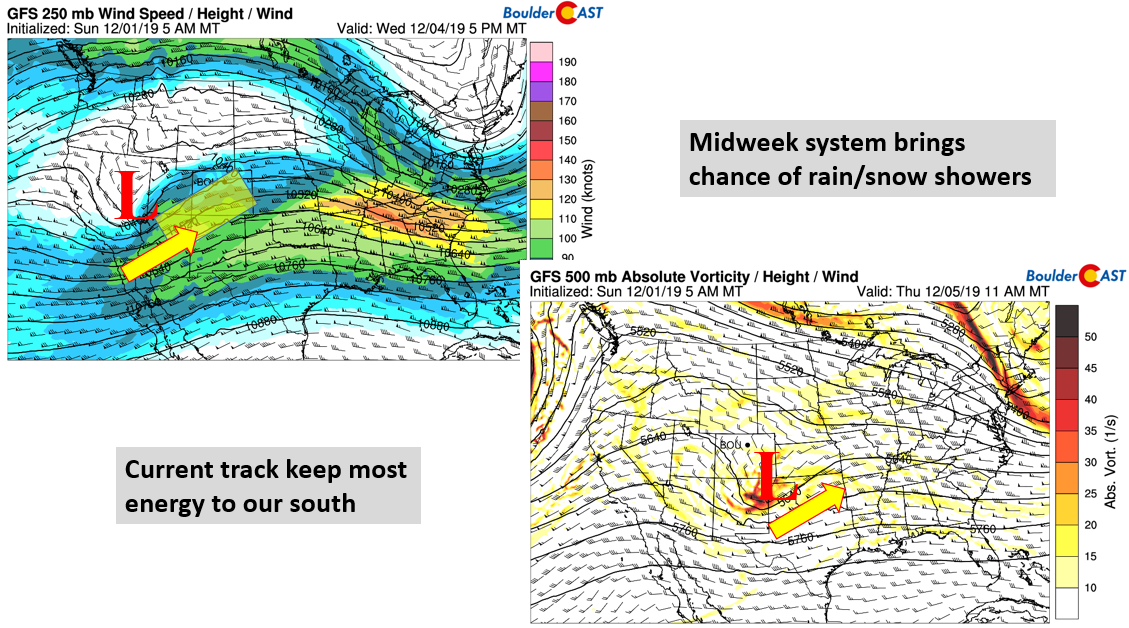
Later tonight into tomorrow morning, the jet stream will move overhead into the state, essentially extending from California into Kansas (below left). The passing of the jet will increase the height/pressure gradient from the western part of our state into the eastern part and give way for gusty winds again for the Foothills and possibly the adjacent Plains, just as we saw on Saturday. Over the weekend, some locations did not get as windy as expected thanks to the low-level inversion in-place. While there is some uncertainty as to how far down the winds descend for the Plains Monday night, gusts up to 50 mph are possible for the western Metro area. The Foothills may exceed 60 mph at times.
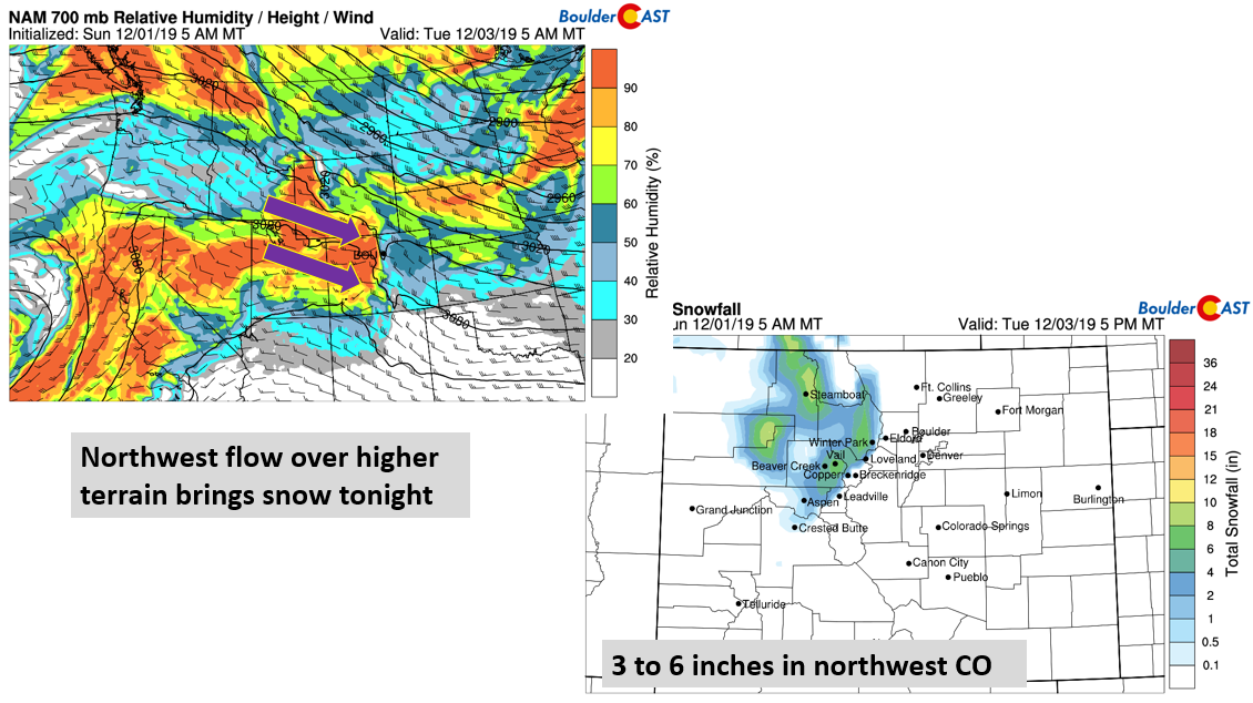
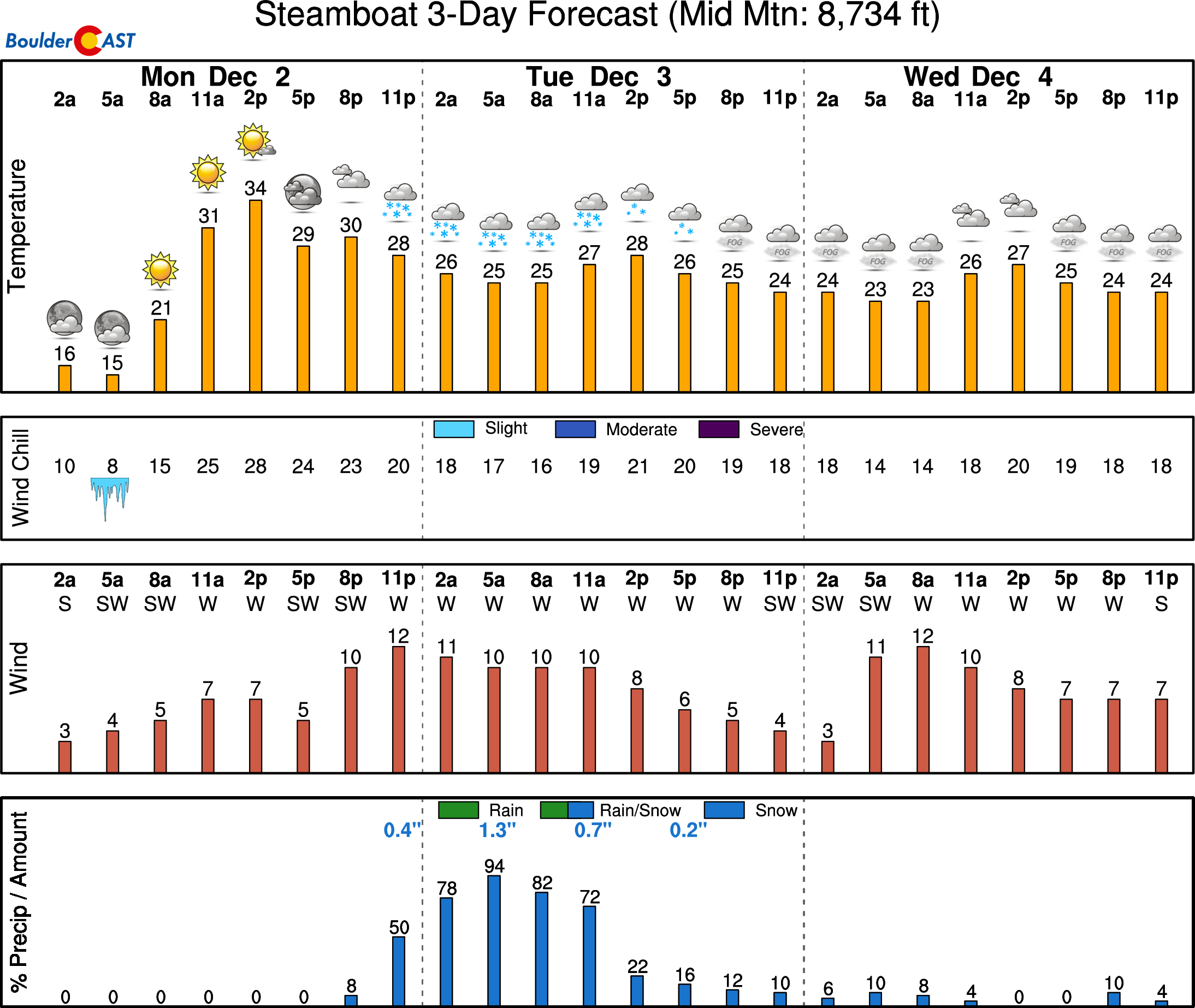
Also of note today will be snowfall for northwest favored slopes, such as Steamboat, Winter Park, Vail, Copper and Beaver Creek. The northwest flow over the state at low to mid-levels (below left) combined with high relative humidity, will lead to a light snow event starting tonight into tomorrow morning. Totals between 2 and 6 inches are possible (below right) before the snow tapers off early Wednesday. Skiers may want to take advantage of this fresh snow!
Midweek system mainly skirts to our south
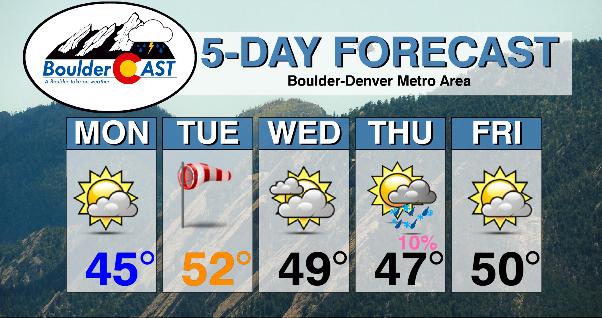
Come Tuesday, a weak cold front slides nearby. It is unclear at the moment if it stays off to our north and east. But in any event, temperatures should stay in the 40’s with snow cover on the ground and the same airmass in place.
The aforementioned system in the Eastern Pacific will make its way onshore into New Mexico and Arizona by the middle of the week. The current trend in the model guidance keeps this system just to our south. The mid-level low in the current GFS model (below right) places it near the Texas Panhandle early Thursday. Overall, expect increasing high clouds on Wednesday along with an ever-so-slight chance of rain/snow showers late Wednesday night into Thursday. Weak upslope will drop high temperatures a tad from Monday and Tuesday’s expected conditions.
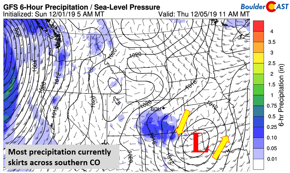
Right now the chance of precipitation is not very high, at best 10% at this point. The reason for this is fairly obvious (below), with the system to our south and much of the energy confined to the higher terrain of southern Colorado. However, if the system wavers further north, our precipitation chance will go up. Temperatures are borderline for snow given the warm airmass so precipitation type would be a mix of rain/snow or just plain rain.
Calm to conclude the week
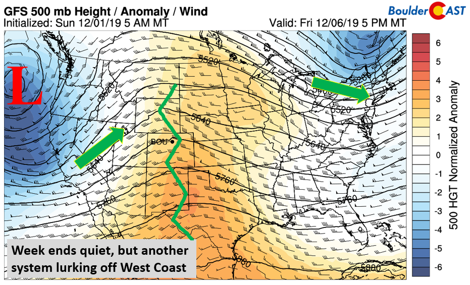
Ending our work week, high pressure ridging takes over yet again (below). This should spell out more sunshine for Friday. However, looking in the long term, another West Coast system is set to move onshore over the weekend, possibly becoming a player for Colorado in due time. Expect a warmer end to the week with less snow on the ground and more sunshine. Highs close to 50 degrees are possible.
Forecast Specifics:
Monday: Sunny skies giving way to upper-level wave clouds in the afternoon. Highs in the upper 30’s to middle 40’s on the Plains and upper 20’s in the Foothills. Overnight strong downslope winds are possible with gusts to 55 mph.
Tuesday: Gusty downslope winds in the morning to 55 mph, then mostly sunny and pleasant. Highs in the upper 40’s to lower 50’s for the Plains and upper 30’s in the Foothills.
Wednesday: Partly to mostly cloudy but dry. Highs in the upper 40’s for the Plains and lower 30’s in the Foothills.
Thursday: Mostly cloudy with isolated rain/snow showers. Highs in the middle 40’s on the Plains and lower 30’s in the Foothills.
Friday: Partly to mostly sunny, dry and warmer. Highs near 50 degrees are possible for the Plains and upper 30’s in the Foothills.
High Country: Expect windy conditions in the higher terrain later Monday and Monday night, along with periods of snow for west and northwestern ski resorts. Totals of 2 to 6 inches are possible in these areas. On Wednesday and Thursday, another system tracks through, but this time for the southern portions of the state. A few inches are possible with this one as well. Quiet weather takes over on Friday statewide. Check our PowderCAST page for always-updated weather forecasts for all of Colorado ski resorts.
DISCLAIMER: This weekly outlook forecast is created Monday morning and covers the entire upcoming week. Accuracy will decrease as the week progresses as this post is NOT updated. To receive daily updated forecasts from our team, subscribe to BoulderCAST Premium.
.
Spread the word, share our forecast!




You must be logged in to post a comment.