After a dry and warm weekend across northeastern Colorado, with portions of the area rising into the lower 90’s, this week will feature a gradual cool down as a large upper-level trough digs southward into the northwestern United States by mid to late week. For a detailed analysis, including forecast uncertainty, read on!
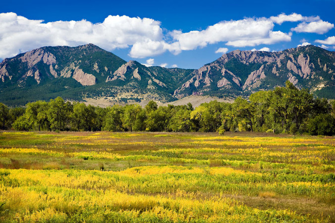
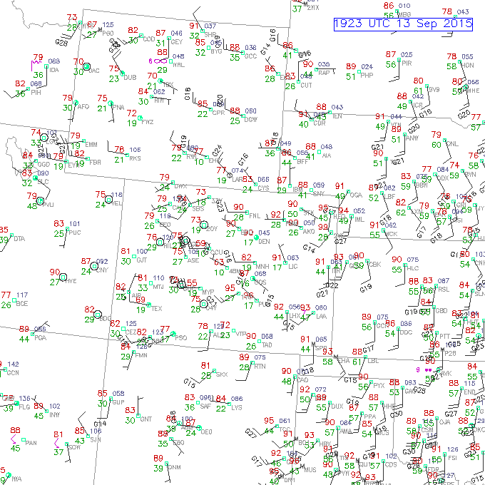
Below shows yesterday’s high temperatures, with much of eastern Colorado in the low to mid 90’s. Even a few locations touched the upper 90’s. The beautiful aspen trees are already beginning to change color. The next two weeks will be key as the foliage peaks in the high country towards the end of September.
Forecast problems this week and uncertainty:
Something new we would like to try this week is give you a sense of a few key factors influencing the weekly forecast and level of uncertainty. For this week, there are a few things to note:
- The main forecast challenge for this week will be temperatures, specifically daytime max readings. A very similar airmass will be in place Monday and Tuesday. However, cooler air settles in Thursday and Friday with a series of cold fronts connected to a large upper-level trough (discussed more below)
- The uncertainty with the forecast will revolve around the timing of the two cold fronts set to move into our region Thursday and Friday. The forecast models are not fully in agreement on the timing or magnitude of the cold air, which will impact the high temperatures late in the week.
- As a result, our forecast highs Thursday and Friday are a little less certain than the beginning of the week
Factors important this week:
Now let’s get into the specifics. The first figure below shows the 500 mb pattern of geopotential heights and absolute vorticity (a measure of cyclones present in the atmosphere) on Monday. As mentioned earlier, a large trough is located across the Pacific Northwest. This will be impacting us starting late Wednesday. But ahead of that, we are under southwesterly flow both at the surface and the upper-levels of the atmosphere. That will spell out similar conditions to Sunday for Monday, with highs in the upper 80’s. With dry air in place and downslope conditions at the surface in Boulder County from a lee trough, we will be dry. However, in the High Country, scattered afternoon storm development is likely with a weak upper-level shortwave moving in from the southwest. So, if you are in the Mountains on Monday, keep an eye on the sky. This pattern will remain with us into Tuesday, with highs only slightly cooler.
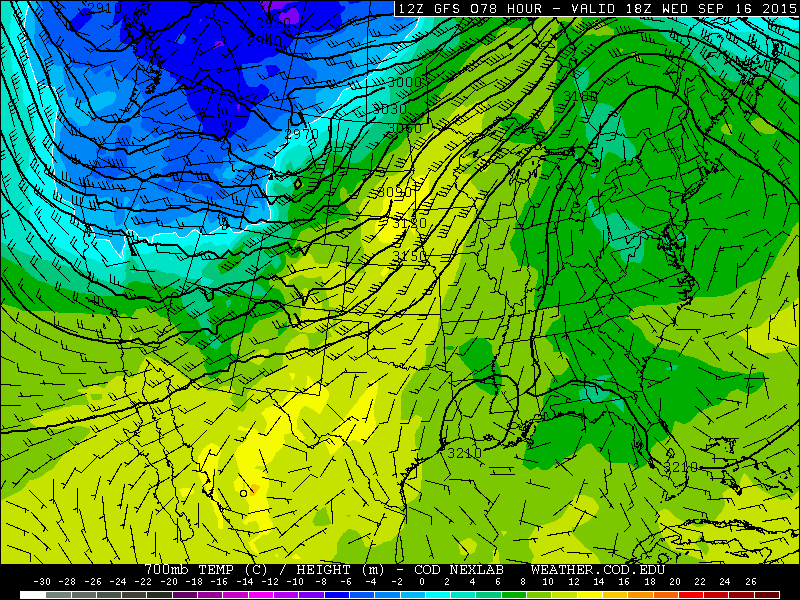
Going into Wednesday, we remain under the southwesterly flow. 700 mb temperatures from the GFS model show a marginally cooler airmass compared to Monday and Tuesday, with temperatures of 10-12 degrees Celsius, suggesting highs in the upper 70’s to lower 80’s. With that, expect a cool down for hump day. It may be breezy as well as the winds at 700 mb (evident below) are around 20 or 30 knots. So gusts of 20 to 25 mph on Wednesday is certainly a possibility. We will also remain dry Wednesday and even through the week as moisture remains limited and the forcing for precipitation will stay to our north in Wyoming. Also of note in the 700 mb temperature plot below is the colder air across the northwestern United States and western Canada. These temperatures are between -6 and -8 degrees Celsius, a sign that fall is fast approaching. Frontal systems now moving southward will have more “punch” to them compared to the summer, so expect a bigger swing in temperatures these next few weeks as we close out September.
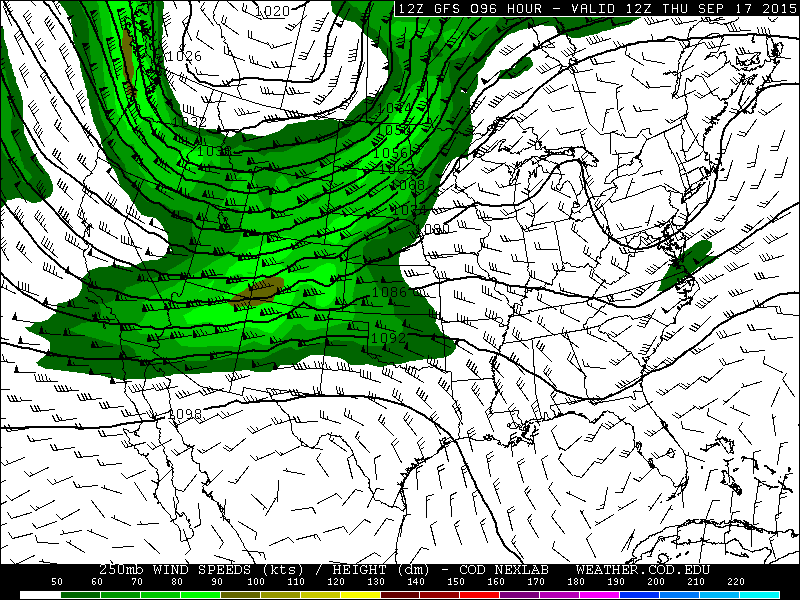
Before we discuss the two cold fronts Thursday and Friday and your forecast highs for the week, we wanted to indicate that it will be rather windy in the High Country late in the week with the aforementioned upper-level trough. Below shows the jet stream pattern for Thursday from the GFS model. Winds will reach 80 to 100 knots. So if you are hiking late this week, be sure to dress warm and be prepared for windy conditions on the peaks.
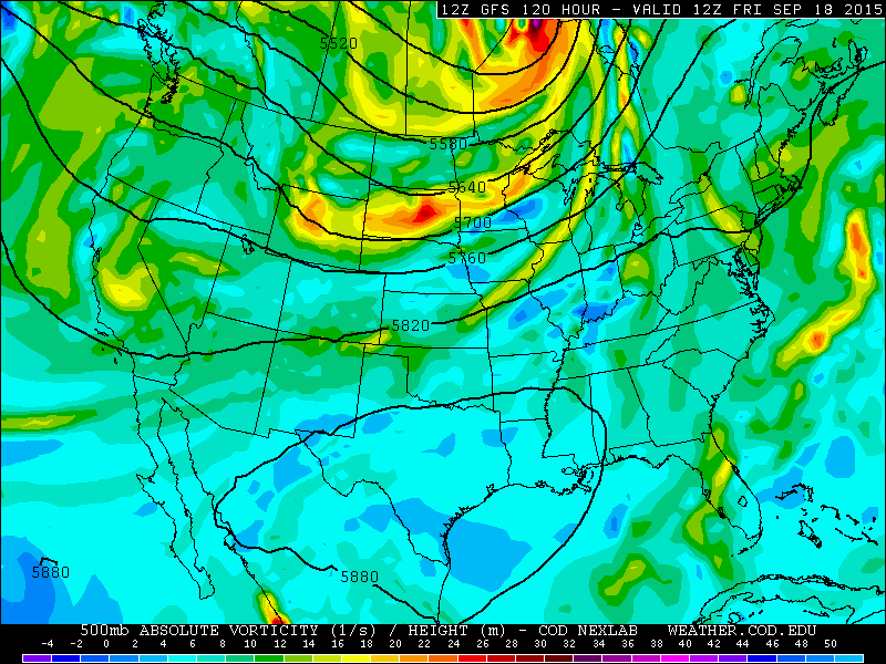
Now for the late week forecast, which focuses on the large upper-trough digging southeastward Thursday and Friday. Below shows the 500 mb absolute vorticity and geopotential height pattern for Friday. This trough will skirt to the north of Colorado, meaning any lift for precipitation will be in Wyoming and the Dakotas. We should stay dry through the week.
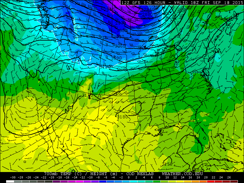
As mentioned earlier, two cold fronts will accompany this upper-trough. The first comes Thursday, with a potentially more potent one on Friday. Below shows the 700 mb temperatures from the GFS model for Friday. Compared to earlier in the week where these mid-level temperatures were above 12 degrees Celsius, the airmass with this trough brings us temperatures of 4 to 6 degrees Celsius by the end of the week. As you can see, the coldest air stays to our north across the upper Midwest, Wyoming, and Montana. This airmass change will likely bring highs in the 70’s Thursday and possibly 60’s on Friday, so a big change is ahead for Boulder County.
The one uncertainty with Thursday and Friday is the timing of the cold fronts and the magnitude of the cold air associated with them. The ECMWF model from the UK shows the first cold front moving through Thursday evening, while the GFS predicts it will arrive Thursday morning. This means highs could be anywhere from the mid to upper 70’s. We will hedge toward the middle 70’s as a result of the uncertainty. On Friday, it will depend on how much cold air is associated with the second cold front. Based on model forecasts, highs could be between the mid 60’s to the lower 70’s, so quite a range of uncertainty. Given this, we will hedge toward near 70 degrees.
The forecast for the week:
Air Quality Forecast: As of this post, there are still a lot of forest fires burning across the Pacific Northwest. However, it appears most of these fires are largely contained thanks to fire fighters. Southwesterly flow aloft Monday to Wednesday will keep air quality and smoke to a minimum with great visibility. With the passage of the cold fronts Thursday and Friday, smoke may move back into the region, but it is difficult to predict how smoky it may get. Just be aware for potential reduced visibility and air quality late in the week.
Monday: Some high cloudiness will be around but overall mostly sunny, gusty from the west-southwest, highs near 90 with low 80’s in the Foothills.
Tuesday: A mixture of clouds and sun, highs remaining mild in the middle 80’s with upper 70’s in the Foothills. Breezy conditions possible at 20-25 mph in the afternoon.
Wednesday: Sunny, breezy, mild, and only slightly cooler. High temperatures in the lower 80’s with upper 70’s in the Foothills. Winds will be between 25-30 mph from the southwest.
Thursday: Sunny and cooler, highs in the middle 70’s with lower 70’s in the Foothills.
Friday: Early morning clouds with afternoon sunshine, much cooler with highs in the upper 60’s with middle 60’s in the Foothills.
High Country forecast:
Expect scattered thunderstorms in the High Country during the day on Monday. Some isolated storms are possible Tuesday and Wednesday with the approach of the upper-level trough. Drier conditions will take over late in the week. Expect windy conditions Wednesday through Friday.
Source
Mon
Tue
Wed
Thu
Fri


BoulderCAST
89
85
85
76
71


NWS
90
86
84
77
72


AccuWeather
88
84
83
78
74


The Weather Channel
86
81
83
78
71
Last week’s recap:
Here are the results of last week’s forecast. First, the forecasts and observations:
The consensus was for temperatures to remain seasonal through the week, with warmer temperatures early, then a cold frontal passage on Thursday. There was no precipitation in the forecast at all, which verified, as much of Northeast Colorado struggled to even form any clouds through the week.
Now the error analysis. Shown is the amount of degrees (in Fahrenheit) that each source was off from the mean observed temperature for Boulder. Positive values indicate the forecast was warmer than what actually occurred, while negative values arise from a forecast that was cooler than what was observed.
Monday through Wednesday were all forecasted too cold. The warming exceeded expectations, with temperatures even climbing into the 90s. Not sure why this was the case, but it may have something to do with limited soil moisture, a byproduct of more than two months of dry weather across the Front Range.
The bottom row of the error table shows the weekly mean error for each weather outlet, a good measure for who was the best and more consistent “forecaster” for the week. Not surprisingly, the best overall forecast for last week goes to AccuWeather, with only 1.6 degrees of error averaged across the period. AccuWeather had the best forecast 4 days in the period. Though never having the best forecast on any day, BoulderCAST came in second place overall.
—
If you haven’t already done so, follow us on Twitter or Facebook for frequent weather updates and subscribe to the site to get these posts automatically delivered to your email box (enter your email in the sidebar widget to right).




You must be logged in to post a comment.