After yet another weekend of winter, our weather quiets down considerably for the upcoming week. We review the snow totals from this past weekend’s storm and discuss the forecast for Turkey Day.
Wintry mix recap from Saturday
This past Saturday, a shallow cold front combined with vastly limited upper-level forcing to produce a day of winter for the Metro area. Depending on where you were located, it was either icy, snowy or some dangerous combination of both.
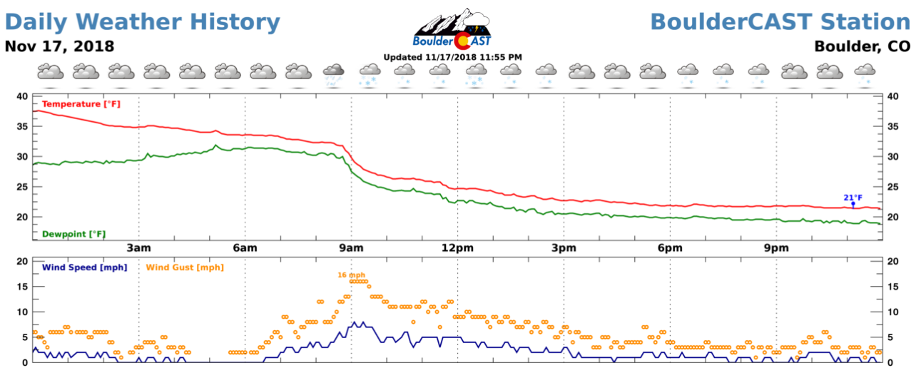
Our original forecast issued on Friday stressed that the main impact would be the freezing drizzle as there wasn’t enough mixing or cold air to form snow crystals in the shallow upslope cloud layer across the Plains for most of the event. We did however expect some snow across the lower elevations, up to 3″ in some locations. The weather history graph for BoulderCAST Station below shows the messy weather and tumbling temperatures present throughout the day in Boulder.
The Boulder area saw the most snow out of this event, as expected, about 1 to 3″, along with freezing drizzle. There was even enough snow during the day Saturday for CU-Boulder students to get scolded by the referee for throwing snowballs at Folsom Field. Further south and east, the rest of Denver saw mainly freezing drizzle, topped off with a dusting of snowflakes later in the day. Travel was at times quite treacherous due to the icing. Highway 93 between Boulder and Golden was closed much of the day as a safety precaution.
Across the higher elevations of Boulder and Larimer Counties, a somewhat rare seeder-feeder setup produced several inches of snow. Moist westerly flow aloft generated orographic snow showers along the Continental Divide, some of which made it over into the higher Foothills and “seeded” the supercooled clouds across the northwestern Metro area. This led to some good snow totals of up to 7″ near Ward and Estes Park.
Shown below is our original snowfall forecast map (issued Friday morning), with the observed storm totals per location contained in boxes. Green ones indicate that the observed snowfall was within one inch of the given forecast range, while red was outside the scope of our forecast.
Overall, good verification for this forecast. It was a tricky one considering the higher odds for freezing drizzle over snowfall early on. The official snow total in Boulder was 2.3″, while Denver reported just 0.2″.
Ridge through mid-week
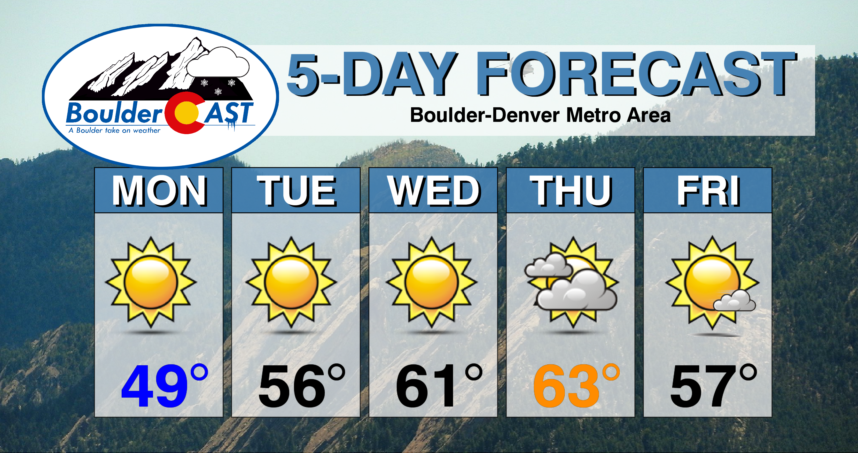
Monday through Wednesday this week will be fairly pleasant for all of Colorado as high pressure slowly builds in from the west (see below). Dry northwest flow will be in place over the northern Rockies, leading to warming temperatures and no chances for precipitation through Wednesday. Look for 50’s Monday and Tuesday, with Wednesday reaching into the lower 60’s.
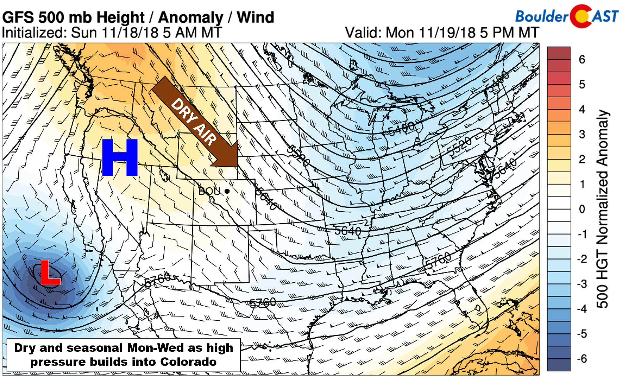
GFS 500 mb height anomaly forecast for Monday. Dry northwest flow and sinking air from the ridge will spell out nice weather.
Mountain snow Thursday and beyond
By late Wednesday, the fair-weather ridge will shift into the eastern United States, opening the door for a train of atmospheric disturbances to come shore in the Pacific Northwest. The first will move across Colorado on Thursday (see below), followed quickly by a stronger system on Saturday.

GFS 500 mb height anomaly forecast on Thursday evening. A weak trough will be moving across Colorado, spreading snow into the Mountains.
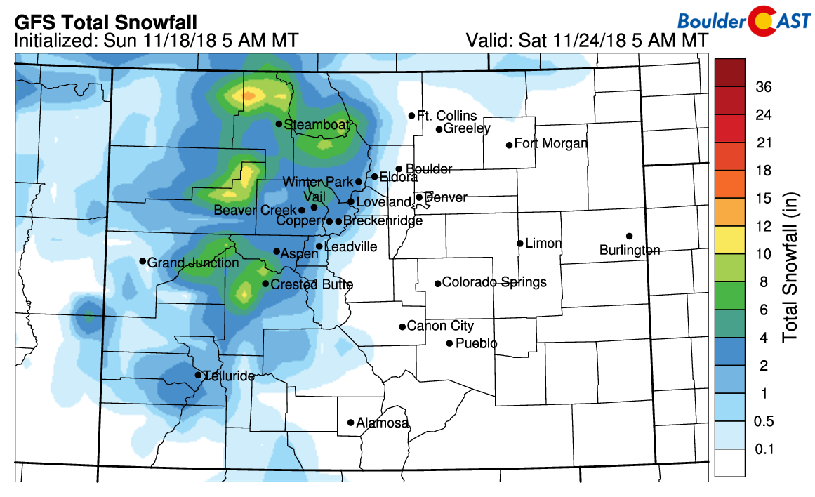
Snowfall will remain confined to the Mountains initially on Thursday and Friday, with downslope keeping things dry across the Metro area. Through Friday night, the latest GFS snowfall forecast paints 4 to 8″ in the High Country. Not a major dumping, but something to watch if you are traveling over the passes for the holiday or planning to hit the slopes a day or two.
Currently it looks like Saturday will be best ski day...
The Thanksgiving holiday is shaping up to be a pleasant one east of the Divide despite the small trough moving through. Temperatures should top out in the 60’s with partly cloudy skies in Boulder and Denver on Turkey Day. A weak Pacific cold front is scheduled for Thursday night which should bring slightly cooler (50’s) and breezy (or possibly windy) conditions for Friday to the region.
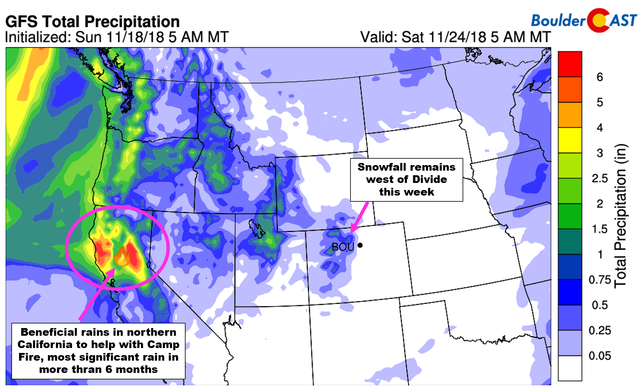
The active storm track to end the week will also be spreading beneficial moisture into northern California. 3 to 6″ of precipitation will certainly help firefighters combating the devastating Camp Fire.
Some uncertainty is evident in regards to what happens with the second, stronger storm system moving into Colorado on Saturday. The GFS keeps the storm as an open wave with mainly more mountain snowfall during the day Saturday (hooray for skiing!). The Euro model has the storm stronger and slower with some indication for snowfall in the Metro area as well. There is too much model variation at this juncture to say for sure what may transpire. Just keep in mind that we are tracking something for the weekend. It wouldn’t be all that surprising if winter arrived just in time to spoil another weekend, would it?
P.S. The incoming troughs late in the week will be packing plenty of smoke thanks to California. Expect overall air quality to go down late Thursday through Saturday for the Metro area.
Forecast Specifics:
Monday: Sunny and mild. Highs near 50 degrees on the Plains and upper 30’s in the Foothills.
Tuesday: Sunny and pleasant. Highs in the upper 50’s on the Plains and in the middle 40’s in the Foothills.
Wednesday: Sunny and warmer with highs in the lower 60’s on the Plains and upper 40’s in the Foothills.
Thursday: Partly to mostly cloudy and warm with temperatures in the low 60’s on the Plains and upper 40’s in the Foothills.
Friday: Mostly sunny and slightly cooler with highs in the 50’s for the Plains and 40’s in the Foothills. Winds could be gusty at times from the northwest.
High Country: Dry and sunny weather will take hold through Wednesday statewide in the High Country. Expect snow showers for most of the Mountains Thursday and Friday, with moderate accumulations possible. Snow will likely continue through Saturday as well. Check PowderCAST for forecasts for all the Colorado ski resorts.
DISCLAIMER: This weekly outlook forecast was created Monday morning and covers the entire upcoming week. Accuracy will decrease as the week progresses as this post is NOT updated. To receive daily updated forecasts, subscribe to BoulderCAST Premium.
.
Share our forecast!







You must be logged in to post a comment.