Following a record-setting cold weekend to kick off summer, temperatures are headed upwards with most Front Range cities likely to see a string of several 90-degree days later this week.
Record cold over the weekend
The first weekend of summer was anything but for Colorado! A very strong storm system dropped south out of Canada late last week bringing chilly temperatures that are more typical of April than June. As the cold air spread southward from Montana into Colorado on Friday, snow levels plummeted to extraordinarily low elevations over the weekend – maybe as far down as 8500 feet. This brought upwards of a foot of fresh snow to the Mountains and even light accumulations to the Foothills communities west of Boulder. The webcam image below is from Sunday morning near Ward at 9000 feet elevation. Summer snow sure is beautiful…
The Metro area didn’t see any snow this weekend, but that’s not to say it wasn’t exceptionally cold. Boulder’s high temperature was 56°F on Saturday and 63°F on Sunday, both new record low maximums for the dates. Sunday morning’s low of 40°F was also a new record. In today’s era of climate change, it’s not easy to break historical records for cold weather, let alone a handful of them all at once!
As you can see in the surface temperature anomaly map below for Sunday afternoon, the cold airmass drug southward by this system brought “the chill” to most of the western United States. The focus over the weekend was primarily on Colorado with temperatures running 25 to 30°F below normal.
In addition to the un-summer-like temperatures, Boulder received more than one inch of rainfall over the weekend. The thick cloud cover that hung around kept our area safe from severe storms, despite very favorable shear profiles on Friday and Saturday. Most of the aforementioned rain fell from light showers and a few tame thunderstorms.
MUCH warmer this week!
Mother Nature has decided that we have endured the cold long enough! The slow-moving storm system responsible for the dreary conditions this weekend is finally pulling away from Colorado with flow turning northwesterly across the state. Ordinarily northwest flow would not constitute much warming for us, but considering the airmass it is ousting, the Front Range will experience a significant jump in temperatures on Monday as a result. Expect highs to shoot-up back into the lower 80’s on Monday with mostly sunny skies and breezy conditions. While still cooler than average, it’s definitely a step in the right direction for us!

GFS 500 mb height anomaly forecast (top left) and 700 mb temperature forecast (bottom right). The low pressure and associated cold air are pulling away from Colorado
The warmth will only continue to build as the week progresses thanks to a developing ridge of high pressure across the center of the country. The 500mb height anomaly animation below shows this ridge amplifying into central Canada by mid to late week along with a deep trough across the Pacific Northwest.
A combination of these two facets (the trough and the ridge) will lead to a swift increase in southwest flow into Colorado creating a real warming trend for us.
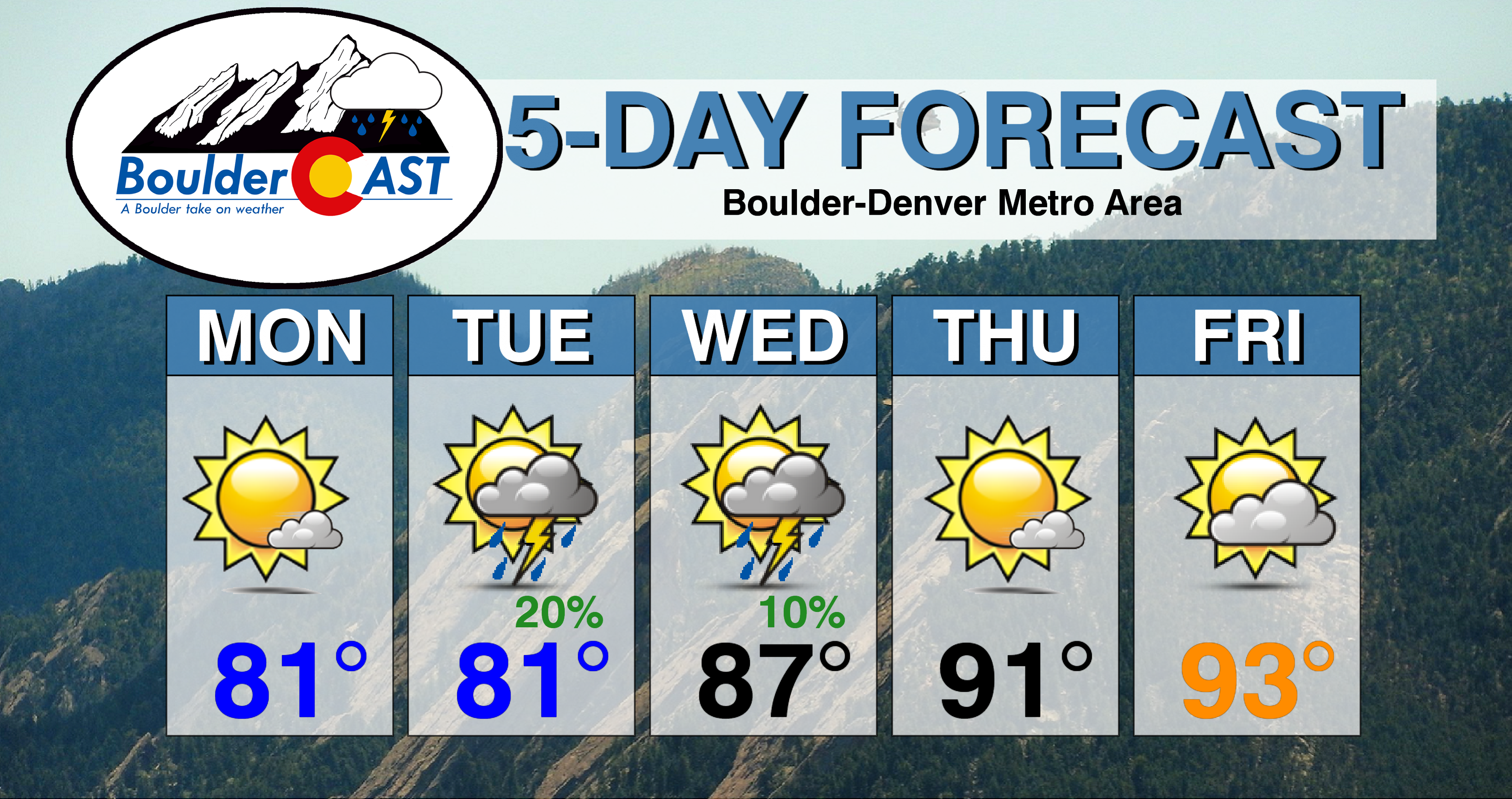
Expect highs to push into the middle 80’s by mid-week, then into the 90’s for Thursday and Friday (and the upcoming weekend)!
Would you believe that neither Boulder or Denver has hit the 90-degree mark yet in 2019? It’s true. Both cities will likely eclipse 90 degrees for the first time this year on Thursday (June 27th). While not the latest by any means, we’re definitely within the top 10% of climatology for the latest occurrence of our first 90-degree day.

The final aspect of the forecast this week is the outlook for rain, or lack thereof actually. The best chance of storms this week will be Tuesday afternoon and evening, though models have only sparse storm coverage across the Front Range. Storms will be driven by daytime heating, drifting eastward into the Metro area from the higher elevations. The low-levels are quite dry, so we’re not expecting much in the way of rainfall reaching the ground. Nonetheless, do keep an eye out for a couple weak storms with some lightning late in the day Tuesday.
The rest of the week should primarily be dry for us, though Friday into the weekend will see isolated storm chances creep back into the forecast as southwest flow pulls in slightly deeper moisture to northern Colorado. The possibility of brief showers and cool outflows could help to take the edge off the 90+ degree temperatures that are likely to persist into the weekend ahead.
Forecast Specifics:
Monday: Mostly sunny, breezy and much warmer. Highs in the lower 80’s on the Plains and upper 60’s in the Foothills.
Tuesday: Morning sun, the partly cloudy and mild with isolated afternoon and evening thunderstorms. Highs in the low 80’s on the Plains and upper 60’s in the Foothills.
Wednesday: Lots of mid and upper level clouds, but warmer with a very slight chance of isolated late-day thunderstorms. Highs in the middle to upper 80’s on the Plains and middle 70’s in the Foothills.
Thursday: Mostly sunny, dry and hot with highs in the lower 90’s on the Plains and upper 70’s in the Foothills.
Friday: Partly to mostly sunny and hot. Highs temperatures in the lower to middle 90’s for the Plains and near 80 degrees in the Foothills.
Weekend: Continued southwest flow will keep temperatures hot across the Front Range with highs in upper 80’s or low 90’s alongside a chance of isolated afternoon/evening thunderstorms each day. Some models are showing the potential for a cold front Sunday, but uncertainty is too high that far out to say for sure.
High Country: The pattern turns quiet and much warmer across the Mountains this week as well. Expect mainly isolated storms Monday through Wednesday with primarily dry conditions Thursday and Friday. Temperatures return to near-normal by mid week and then push above normal late in the week. All that fresh snow will be melting quickly!
DISCLAIMER: This weekly outlook forecast was created Monday morning and covers the entire upcoming week. Accuracy will decrease as the week progresses as this post is NOT updated. To receive daily updated forecasts from our team, subscribe to BoulderCAST Premium.
.
Spread the word, share our forecast!


You must be logged in to post a comment.