
This week will feature very hot temperatures across the Front Range with some areas likely pushing into the triple digits. Storm chances will exist only early in the week. We cover the HEAT WAVE at-hand and the potential for monsoon moisture making it to Colorado just in time to cool us off for the upcoming weekend.
A few storms to start the week, heat ramps up
Today’s large-scale weather pattern is shown below. In the central United States are the remnants of Hurricane Barry which made landfall in Louisiana over the weekend and continues to dump heavy rain across the southern Midwest. Further west, a high pressure center is over Arizona which will build and strengthen throughout the week. To the northwest is a trough of low pressure. This low pressure and the ridge will combine this week to bring in the hottest air we’ve seen so far this summer.
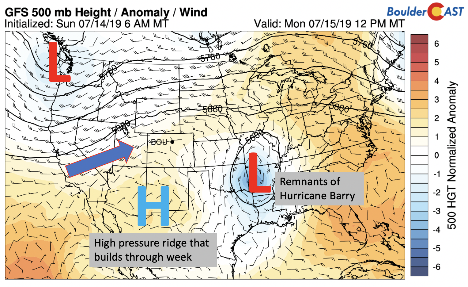
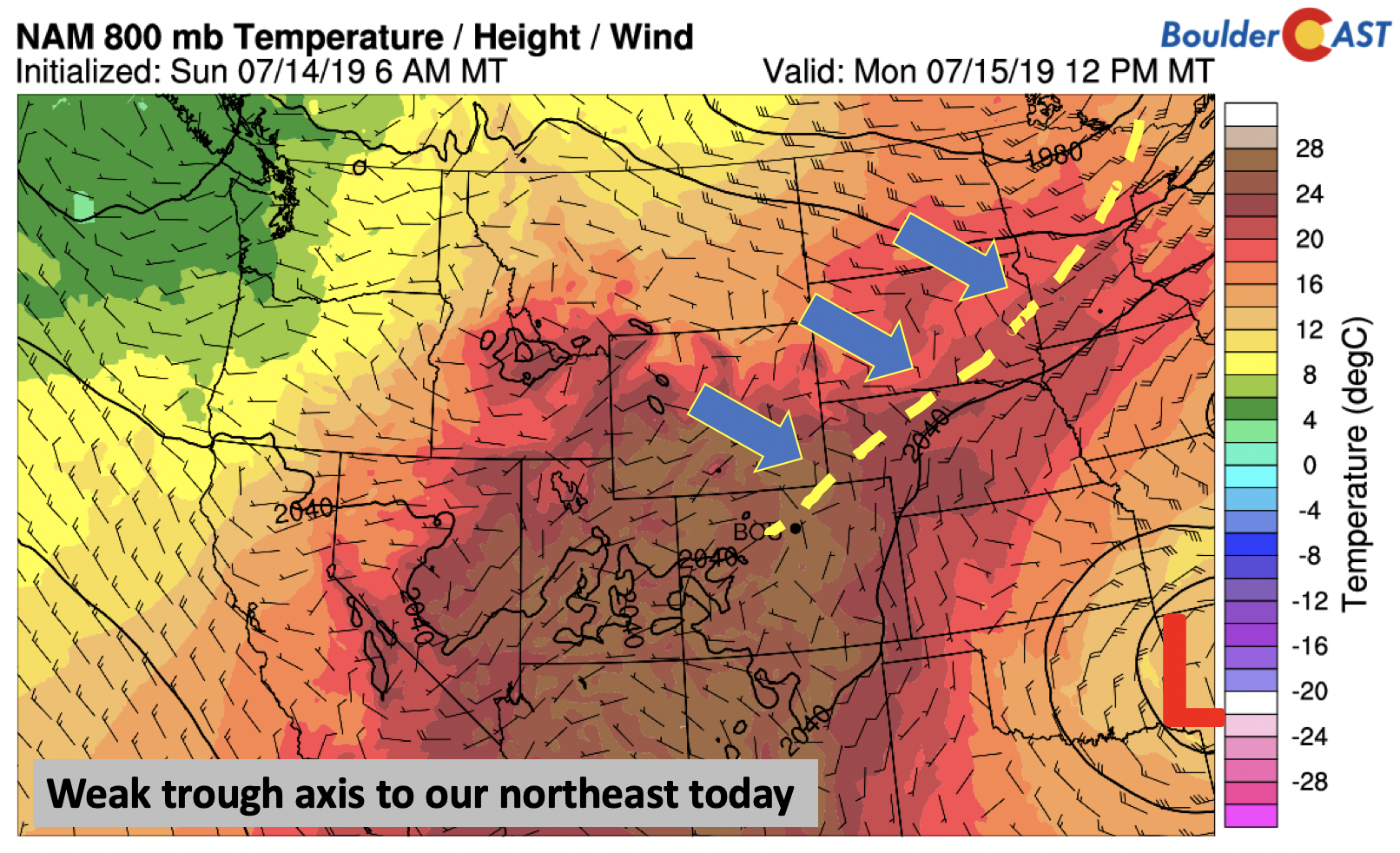
Although likely not a huge player in today’s forecast for the Metro area, there is a weak trough axis to our northeast from Minnesota southwest into Nebraska and northeast Colorado. The same mid-level pattern we experienced this past weekend is still in-place, and this trough axis will concentrate lift once again over the area for scattered late-day storms, particularly across far northeast Colorado where some storms could even turn severe Monday afternoon and evening.
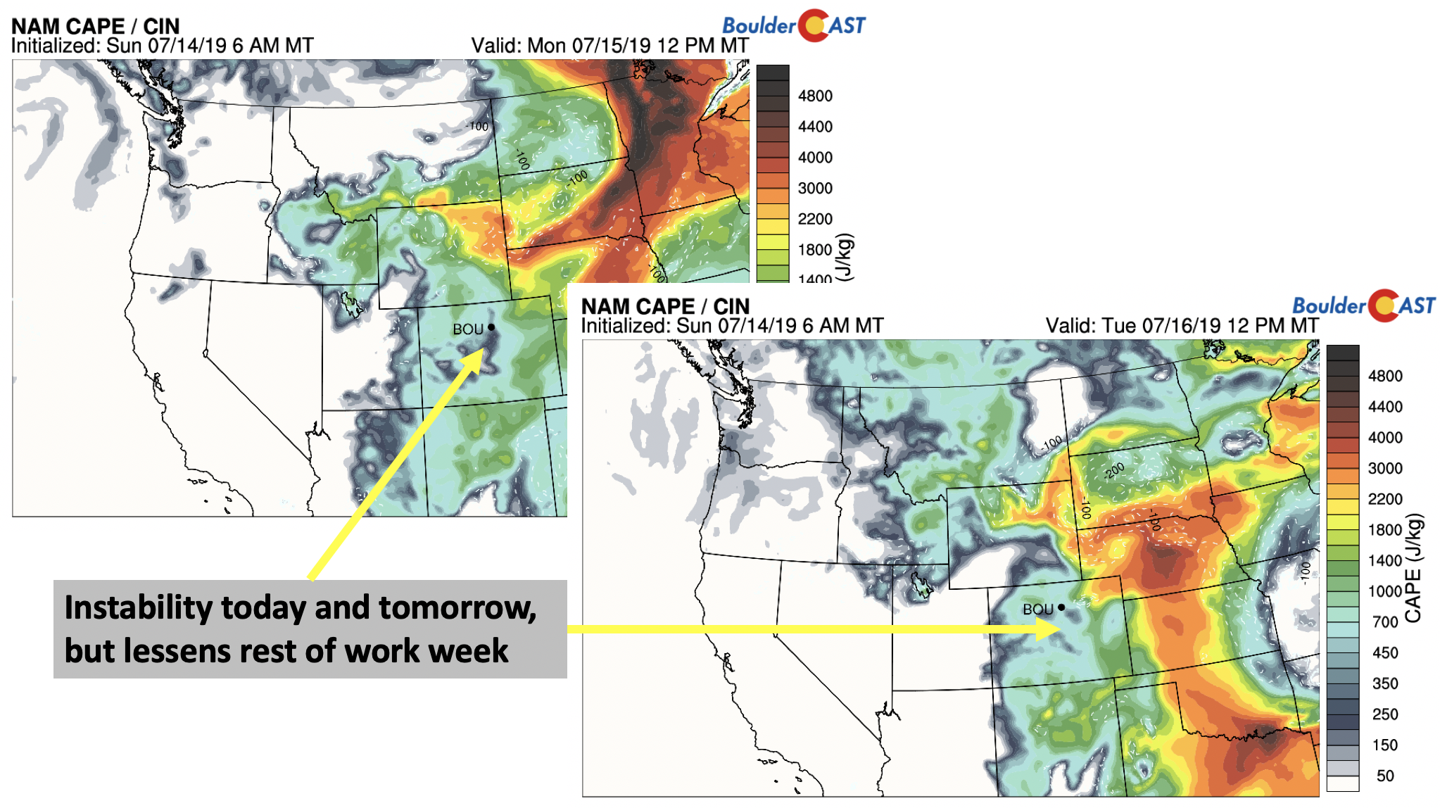
The first two days of the work-week will see highs in the middle 90’s. Today and tomorrow also, the instability (below) will be largely supportive of scattered storm activity to remain in the forecast. Today, with only a slight decrease in moisture, the chance of storms is 30%. On Tuesday, a similar percentage sounds reasonable, potentially 20% due to drier air starting to work in from the southwest in response to the ridge and trough pattern discussed earlier. By Wednesday, the chance of storms is at best only 10% as heat and dry air build in further.
Heat, Heat, Heat!
As we go from Wednesday through Friday, the pattern favors very warm and dry conditions including lots of sunshine and virtually no threat of storm activity.
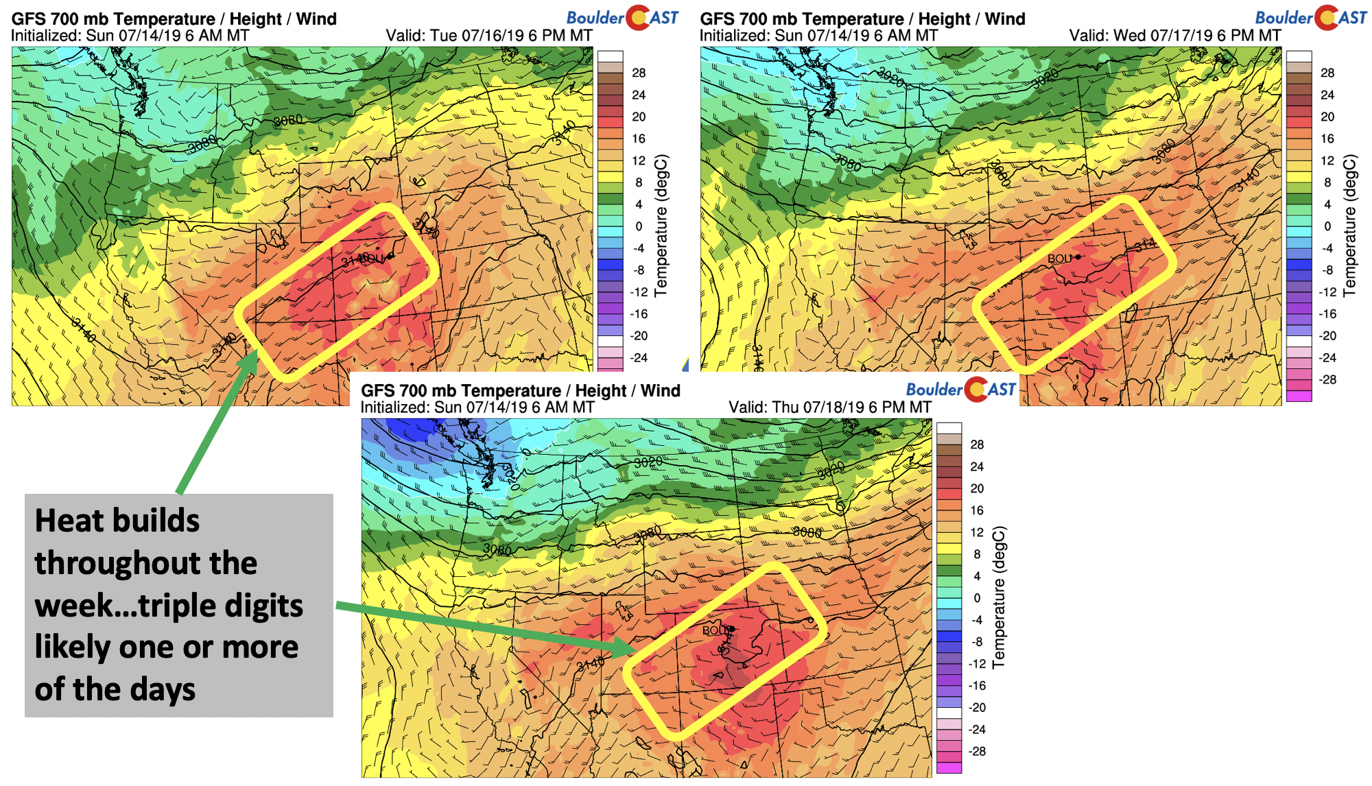
The temperature pattern is shown below for ~10,000 feet up, the 700 mb level for Tuesday (bottom left), Wednesday (bottom right), and Thursday (bottom center). Temperatures in the low to mid-levels of the atmosphere increase each successive day, from about 18°C on Tuesday, to 21°C by Thursday. This airmass will be supportive of surface temperatures in the upper 90’s from midweek through Friday, with likely some portions of the Metro area reaching triple digits on a day or two. You’ll notice, the wind pattern in the maps below too. The flow is southwesterly, bringing in the hot and dry air from the Desert Southwest.
Tied to the temperature of the airmass is the moisture pattern (below) for Wednesday (bottom left), Thursday (bottom right), and Friday (bottom center). As discussed earlier, drier air starts to work in late Tuesday, but fully moves into the area by Wednesday and Thursday, as noted by the brown colors encroaching on the state of Colorado. This will reduce instability. Along with the warm air aloft for capping, we’re not expecting any storm development over the High Country or Plains.
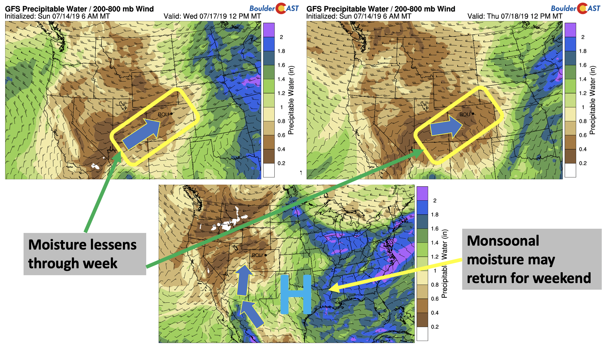
By Friday, though (above center), there are signs that monsoonal moisture may re-emerge across the state for the upcoming weekend. The ridge is partly predicted to drift a little to our southeast, allowing a southerly flow, as opposed to southwesterly, bringing deeper moisture content into Arizona and Colorado. Models have not done a great job predicting the exact location of this high recently, so it is definitely uncertain at this point. Friday will likely still remain very hot and dry, but the weekend may see storms return to the forecast for the Mountains and Plains with temperatures trending a little cooler.
Forecast Specifics:
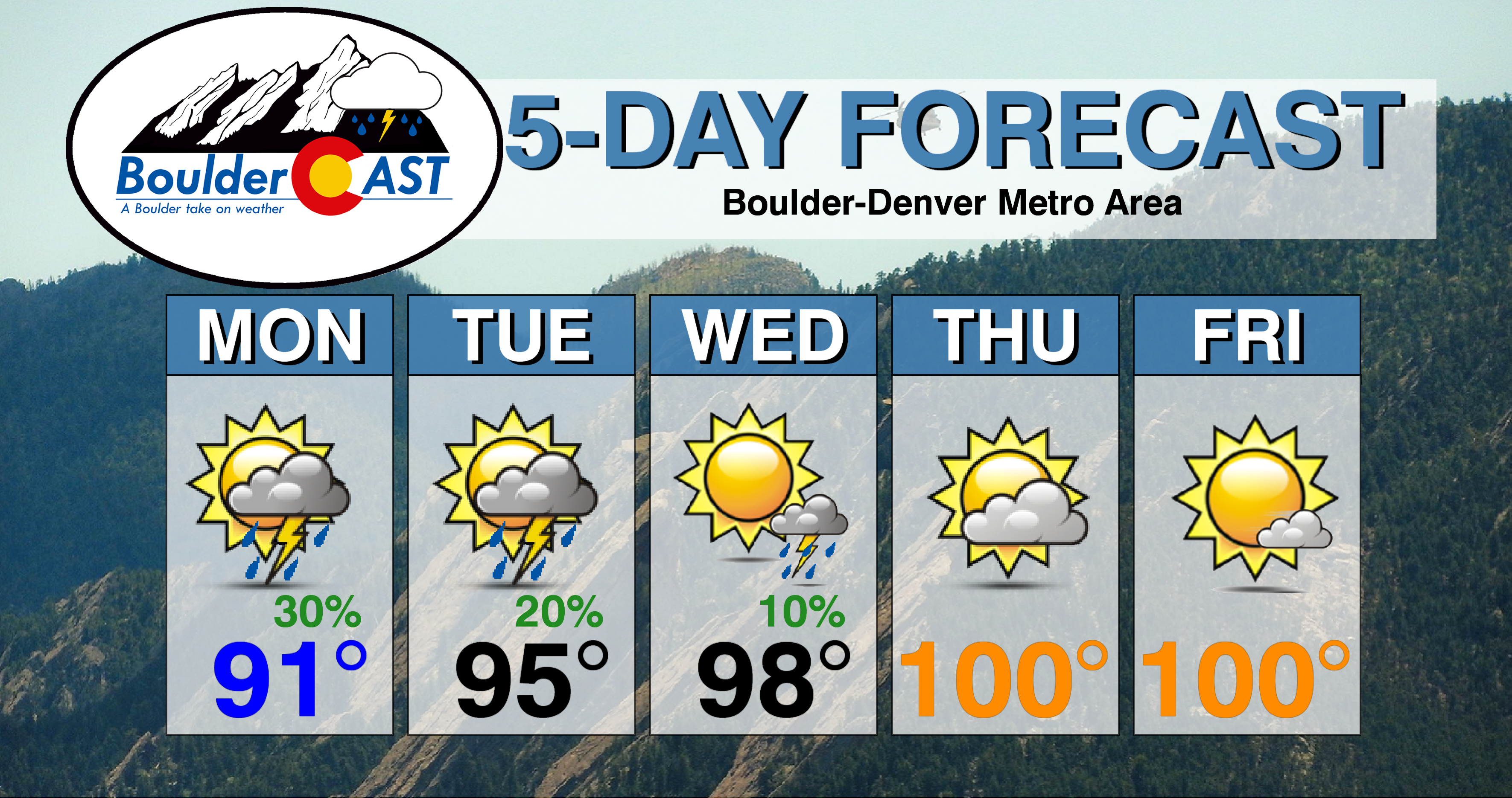
Monday: Sunny skies giving way to afternoon clouds with scattered storms in the afternoon and evening. Storms capable of brief heavy rain and lightning. Expect highs in the low to middle 90’s across the Plains and in the lower 80’s in the Foothills.
Tuesday: Morning sun, then hot with a mix of clouds and sunshine with isolated storms in the afternoon and evening. Highs in the middle 90’s across the Plains and in the lower 80’s in the Foothills.
Wednesday: Sunny and hot with only a slight chance of a storm, mainly south of Denver. Highs in the mid to upper 90’s across the Plains and in the low to middle 80’s in the Foothills.
Thursday: Very hot and dry with partly sunny skies. Highs in the upper 90’s to near 100 on the Plains and middle 80’s in the Foothills.
Friday: Mostly sunny and ver hot with highs near 100 degrees on the Plains and middle 80’s in the Foothills.
High Country: Monday and Tuesday will offer the best chance of storms across the Mountains as moisture is elevated coupled with weak waves of energy. The storm threat lessens Wednesday through Friday as drier air works into Colorado. Scattered storms will likely build back into the area over the upcoming weekend with the return of deeper sub-tropical moisture. Visit our SummitCAST page for updated forecasts for more than 120 Colorado mountain destinations.

The view from 14er Mount Yale on July 13, 2019. SummitCAST didn’t disappoint…the weather was absolutely perfect!
DISCLAIMER: This weekly outlook forecast was created Monday morning and covers the entire upcoming week. Accuracy will decrease as the week progresses as this post is NOT updated. To receive daily updated forecasts from our team, subscribe to BoulderCAST Premium.

.
Spread the word, share our forecast!


You must be logged in to post a comment.