All in all, we start out the first week of April on the mild side. With the exception of Wednesday, we’ll see an increasing trend towards spring-like temperatures. A few systems will be tracking through during the week which will also lead to our first chances for April showers. We detail this and more in our week ahead!
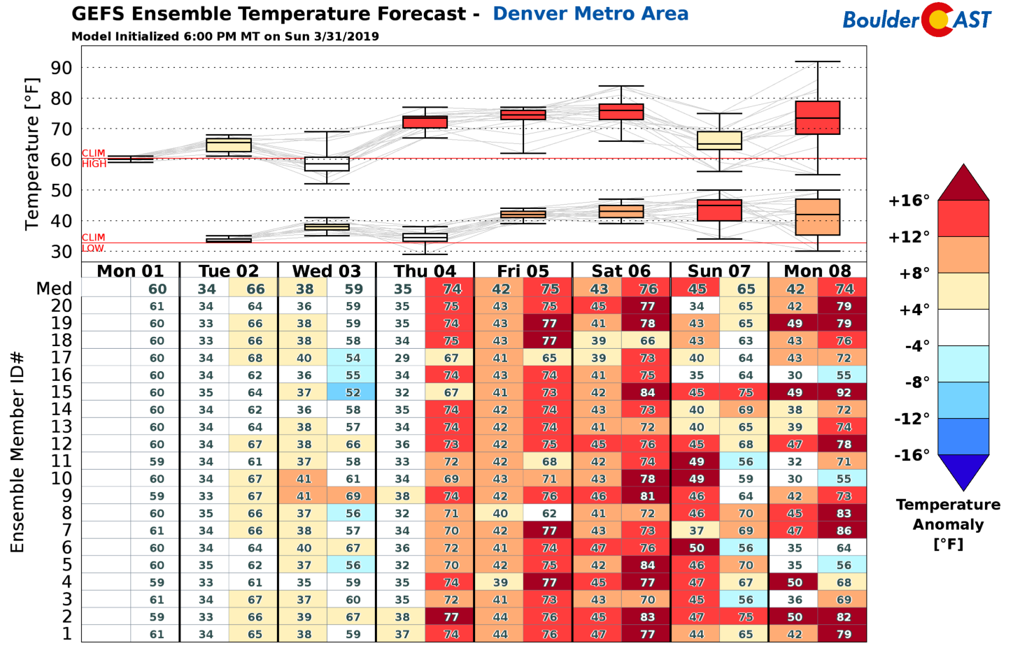
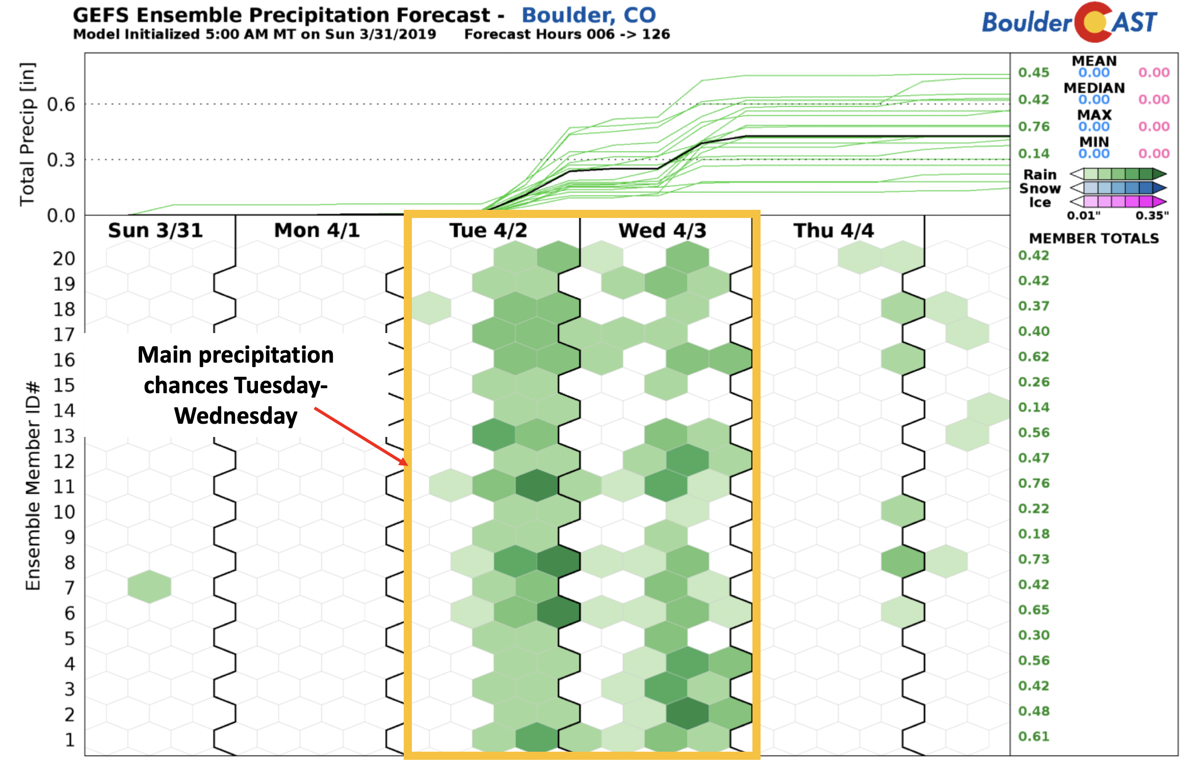
Below shows the weekly outlook in terms of both temperature and precipitation from the GEFS ensemble model. As for temperatures, you’ll notice that the majority of the week has lots of red and orange colors, a sign of above normal weather in store for us. The one exception is Wednesday, where a mid-level system passes through.
As for precipitation, the primary days for possible unsettled weather are Tuesday and Wednesday. We’ll detail this all in our week ahead below but wanted to give you head’s up for your weekly planning.
Week starts off quiet
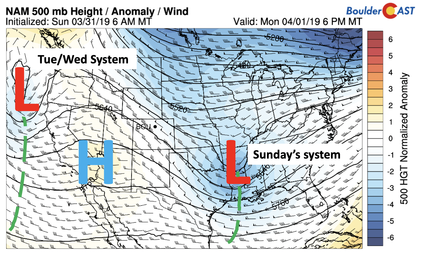
Our week starts off on a quiet note. The mid-level height anomaly pattern is indicated below for this afternoon/evening. Sunday’s system, which brought snow to the Colorado mountains in the southwest part of the state is now off into Arkansas. High pressure is building today from Arizona and California. A system offshore in the Pacific is our player for Tuesday and Wednesday. With a west-northwest flow today, sunny skies will prevail overall (some high clouds may drift in) with temperatures warmer into the upper 50’s.
Slightly unsettled midweek
Come Tuesday, temperatures will be a few degrees warmer than Monday in the lower 60’s. However, increasing clouds will be building through the day and remain through Wednesday. Precipitation chances will also increase, primarily by Wednesday. Both global and regional models show another southern track system (below) pulling from west to east over northern New Mexico and near the Colorado border late Tuesday through Wednesday. The NAM (right) is stronger and deeper and further north than the global GFS model (left), so some differences remain.
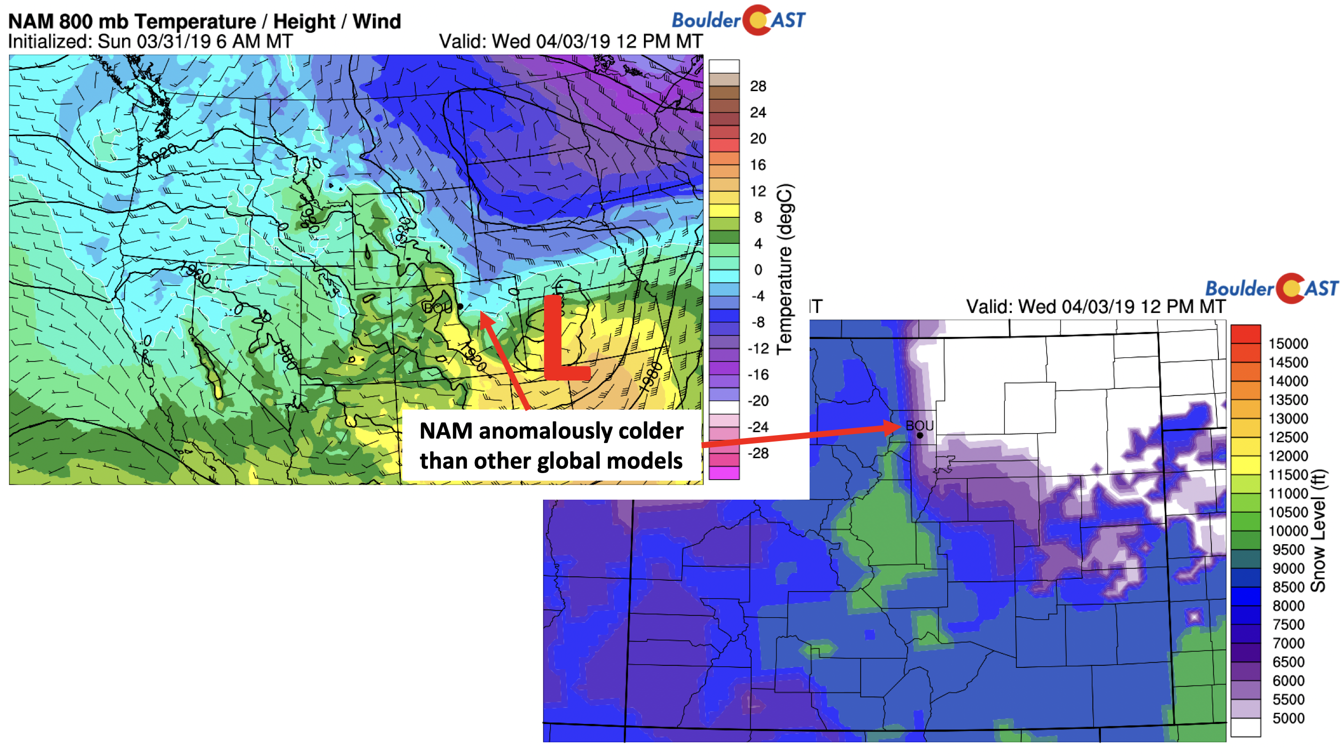
These differences largely effect the temperature profile in the low and mid-levels and possible precipitation type. The NAM near-surface temperatures (below) show the zero degree freezing line right near the Denver Metro midday Wednesday, placing snow levels close to 5500 feet. However, this model appears to be an outlier as the GFS shows snow levels at or above 8000 feet with a warmer airmass and less deep wrap-around of cold air. We will hedge on the warmer trend, but the Foothills will likely see a mix of rain and snow.
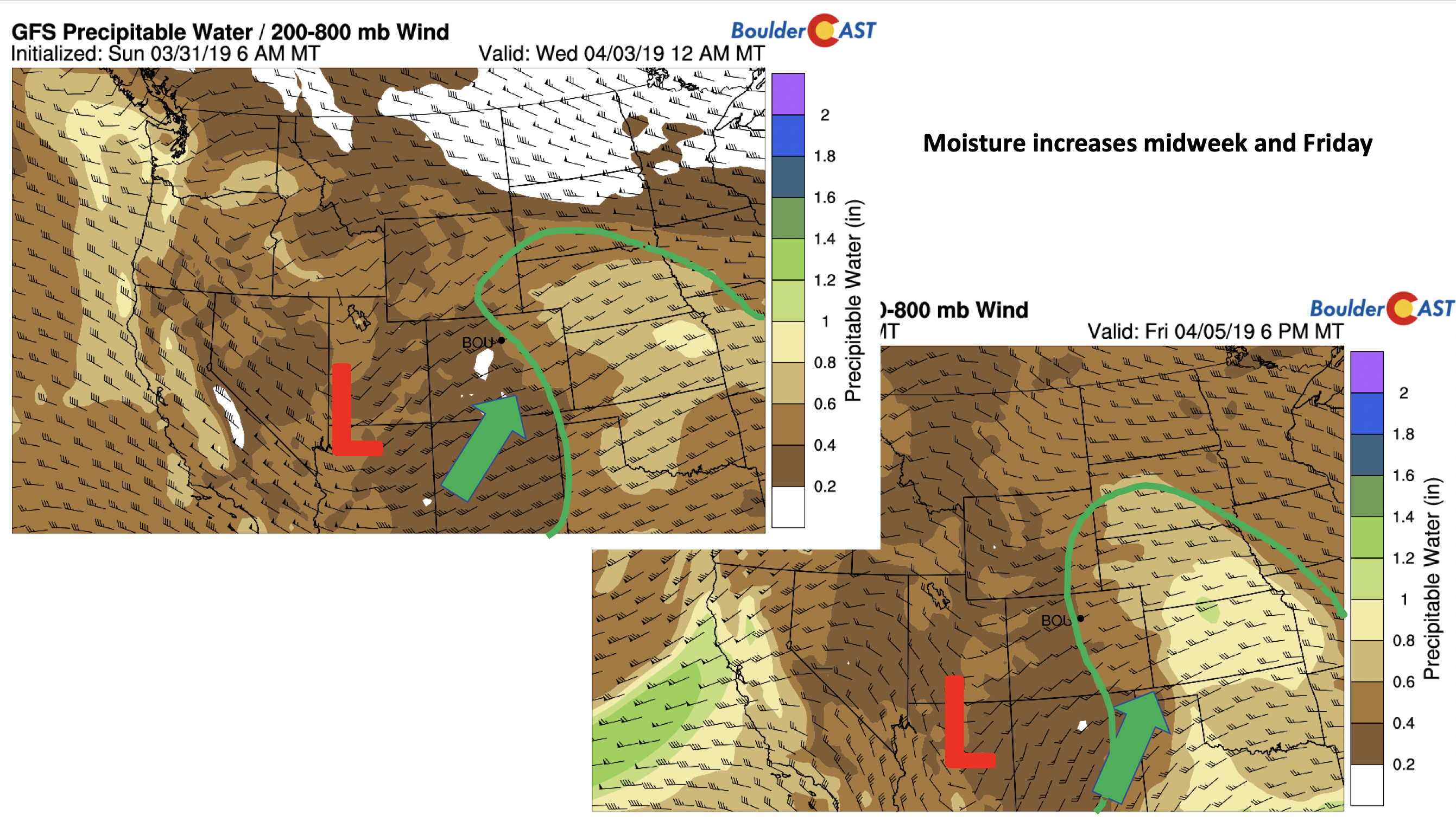
The Tuesday/Wednesday system and another weak one Friday both will be bringing in moisture from the Pacific. The precipitable water values on Wednesday and Friday (below) increase to between 0.4 to 0.6 inches, definitely above normal. You’ll also notice below the nice fetch of moisture coming from the south.
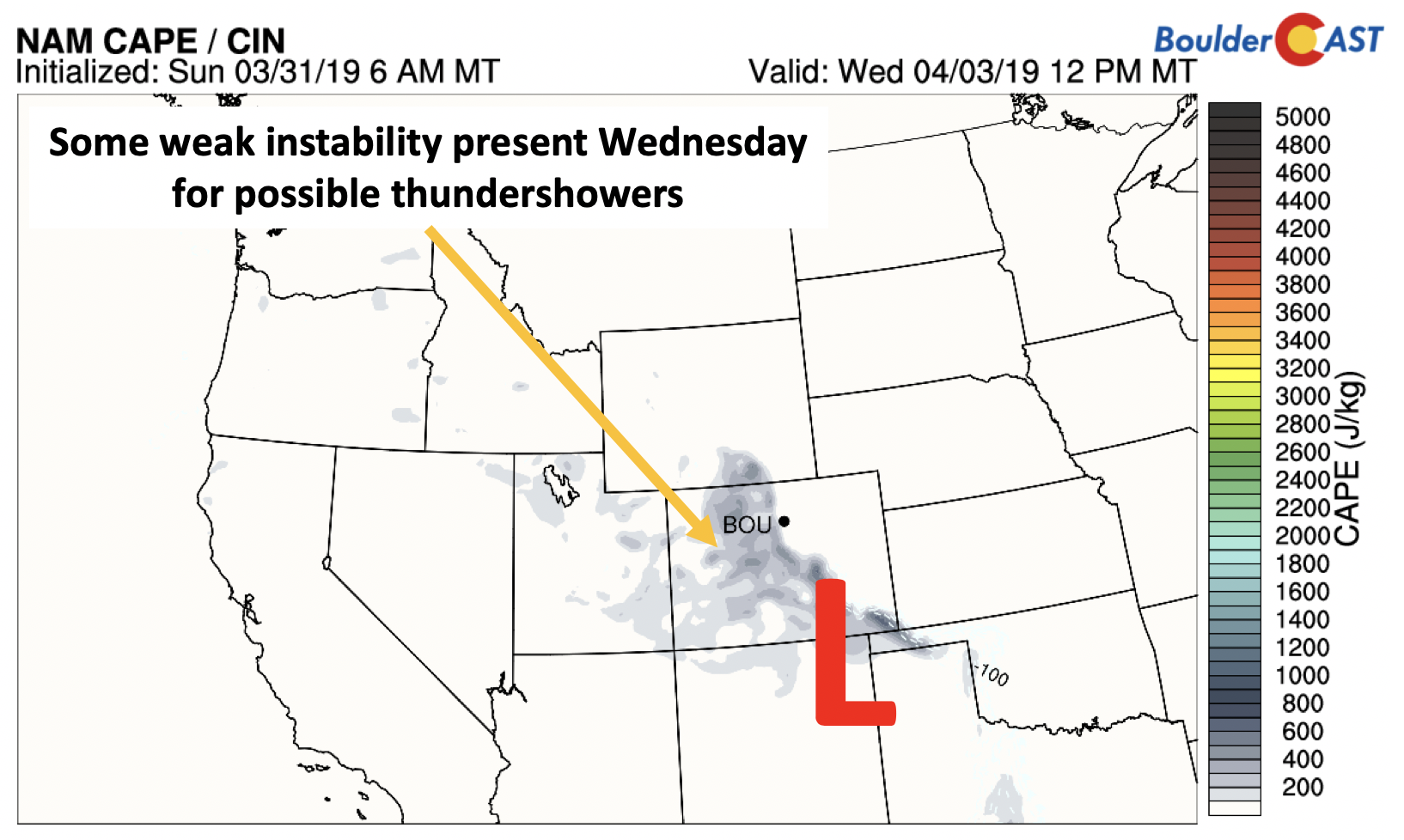
In addition, some weak instability will be present during this event, making there a possibility of some isolated storms/thundershowers for the mountains and Plains (below).
So you’re probably thinking: “What does all of this mean for the forecast?”
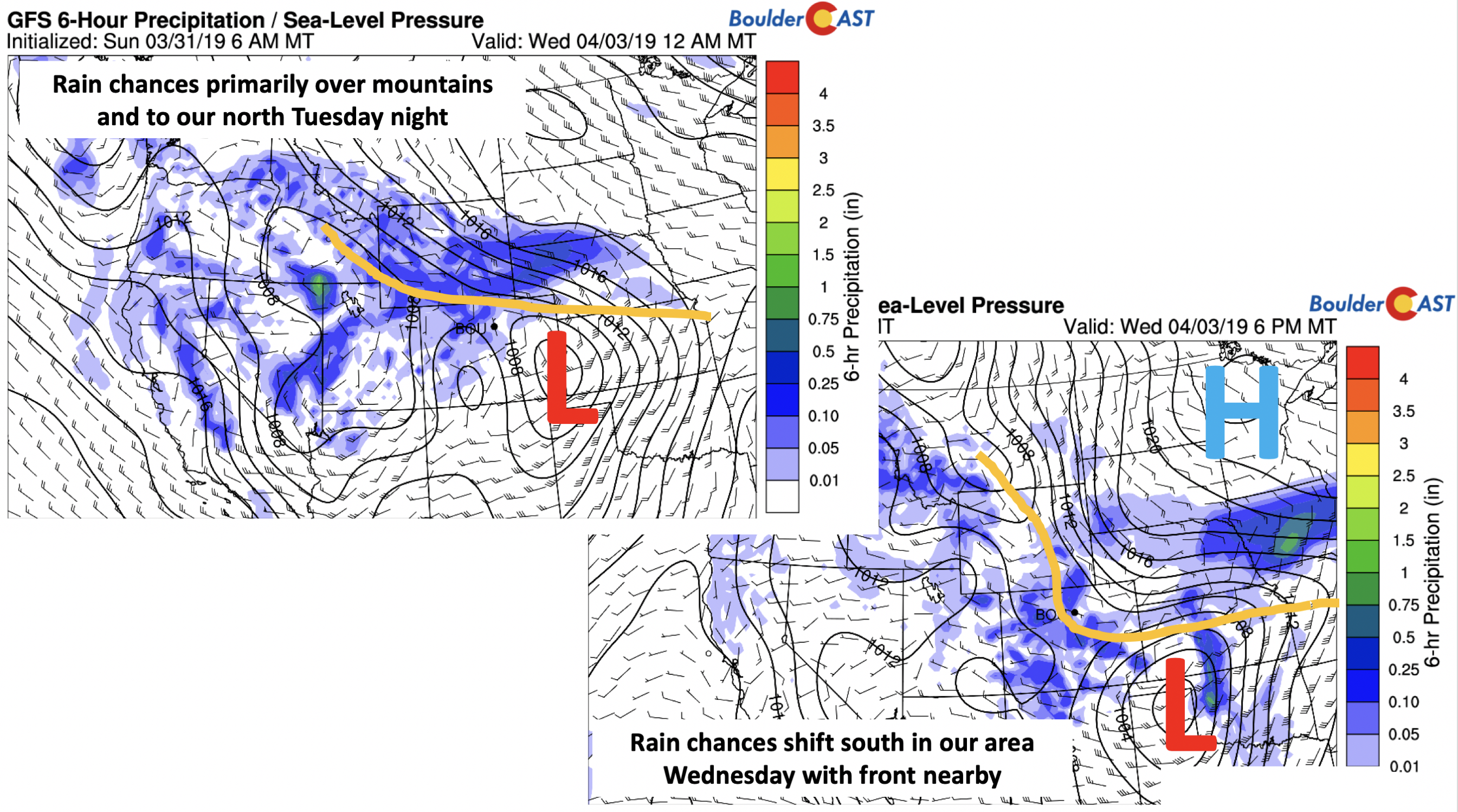
Well, we think both Tuesday night and Wednesday afternoon/evening are the two primary chances of unsettled weather. Tuesday starts off mild as we said before, with increasing clouds. It appears the chance of rain (too warm for snow on the Plains) Tuesday will primarily be confined to the north of us across Wyoming in proximity to the frontal boundary and upper-level jet streak. Snow showers will be present in the High Country though. We can’t rule out some isolated rain showers Tuesday evening and night. On Wednesday (bottom right), with the approach of the system, the frontal boundary moves south, lowering highs into the 50’s and increasing upslope for a better rain chance. We thus put a higher probability on Wednesday at this point, but certainly not a deluge of rain by any stretch. Watch out for the chance of scattered rain or thundershowers in the afternoon and evening.
Week ends quiet with a slight chance of storms
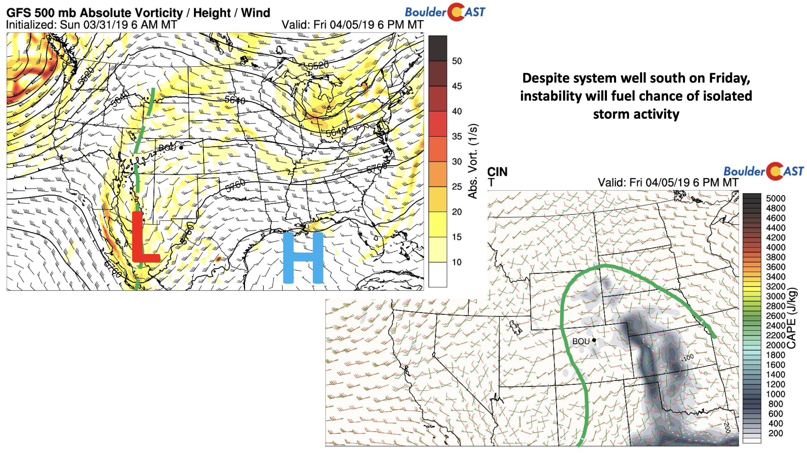
Thursday returns our warm-up most likely as ridging takes over briefly. Highs should return back into the 60’s. On Friday (below), another southern track system moves west to east. But this time, its located well south in Mexico. However, even though all models place it well south, some instability (bottom right) is showing up in the longer range from the milder temperatures and increased moisture. This along with a few ripples of energy from the system could touch off a few isolated afternoon/evening storms. We’re only expecting about a 10% chance of storms for our region at this point.
As we go into the weekend, a VERY STRONG storm system is progged to take aim on the entire state of Colorado. Although it is uncertain, the potential exists for over a foot of snow for the Denver/Boulder areas and even more for the mountains. We will continue to watch this storm through the week and provide updates as necessary. April Fools! If we got you, don’t worry, we still have plenty left of April to see more snow….
P.S. If you missed our recap of the snow we had Friday night, catch up HERE.
Forecast Specifics:
Monday: Generally mostly sunny with a few passing high clouds. Highs on the Plains in the upper 50’s and in the upper 40’s in the Foothills.
Tuesday: Increasing clouds with a 10-20% chance of evening showers. Scattered rain and some snow showers are possible in the Foothills. Highs near 60 on the Plains and mid 40’s in the Foothills.
Wednesday: A 30% chance of afternoon/evening showers and thunderstorms with highs in the lower 50’s on the Plains. Highs in the upper 30’s in the Foothills with light snow showers possible.
Thursday: Partly sunny and warmer with highs returning to the lower 60’s for the Plains and upper 40’s in the Foothills.
Friday: A mix of clouds and sun with a 10% chance of afternoon/evening thundershowers. Highs on the Plains in the upper 60’s with middle 50’s in the Foothills.
High Country: Today is quiet in the mountains, but turns unsettled tomorrow and Wednesday with likely rain/snow showers. Some rumbles of thunder are also possible. A quiet day returns Thursday, with the week ending with isolated/scattered rain/snow showers on Friday. Check PowderCAST for updated forecasts for all the Colorado ski resorts.
DISCLAIMER: This weekly outlook forecast was created Monday morning and covers the entire upcoming week. Accuracy will decrease as the week progresses as this post is NOT updated. To receive daily updated forecasts from our team, subscribe to BoulderCAST Premium.
.
Share our forecast!





You must be logged in to post a comment.