A series of subtle disturbances through midweek with an approaching cold front will favor increased chances of scattered showers and storms Monday through Wednesday. Highs will largely reside near normal through this period. A ridge of high pressure will start to settle into Colorado by the end of the week, resulting in drier conditions and intensifying heat.
This week’s highlights include:
- Largely zonal flow at mid-levels through midweek with several disturbances in the pattern
- Aforementioned disturbances and a front will favor isolated/scattered thunderstorms through midweek — some being severe east of Denver
- Storm chances lessen Thursday and Friday
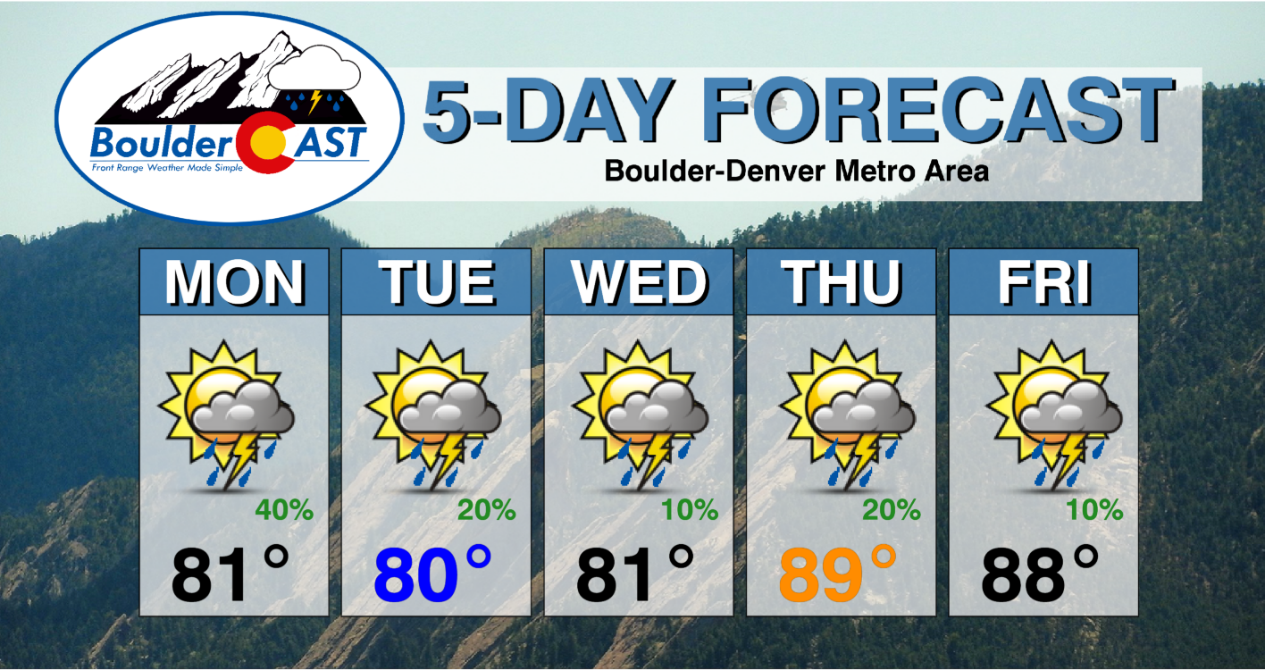
- Highs in the lower 80s into Wednesday, trending warmer towards 90 degrees by late-week
- Quite hot for the weekend but pattern shift possible late Sunday
DISCLAIMER: This weekly outlook forecast is created Monday morning and covers the entire upcoming week. Accuracy will decrease as the week progresses as this post is NOT updated. To receive daily updated forecasts from our team, among many other perks, subscribe to BoulderCAST Premium.

Scattered showers/storms, some being severe, into midweek
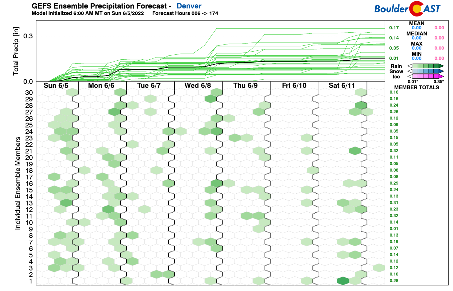
If we take a look at the GEFS ensemble plume precipitation forecast for the week, what jumps out is how sporadic the precipitation chances are, spread out through the entire week. In some sense, this week will be driven by low-amplitude disturbances in the zonal flow. Each disturbance will risk the potential for late-day showers and storm with instability, shear, and moisture in place. However, we think the best chances are the first half of the week. We’ll do our best to illustrate this as we go through this outlook.
The pattern across the nation Monday depicts a series of shortwaves, one off the coast of the Carolinas (behind departing Tropical Storm Alex), one over the Great Lakes into the Ohio Valley, and a third from Montana into Colorado. For our weather Monday, while zonal flow is in place, the disturbance tracking through will aid in the development of scattered showers and storms. This pattern will be much the same story on Tuesday as well.

On top of the mid-level zonal flow, a strong jet streak will be overhead, stretching from Nevada into Nebraska this evening. While our region is not in the most favored spot of the divergent portion of the jet streak, the presence will add to strong deep-layer shear for severe thunderstorm potential.

With morning and early afternoon sunshine, highs will top out in the lower 80s. Increasing clouds from instability, approaching 1000 J/kg on the Plains and 500-1000 J/kg over the High Country, will aid the development of storms over the higher terrain, moving towards the Plains in the afternoon and evening. The strong flow of 40+ mph at mid-levels will favor severe storms in spots that have the deepest convection.
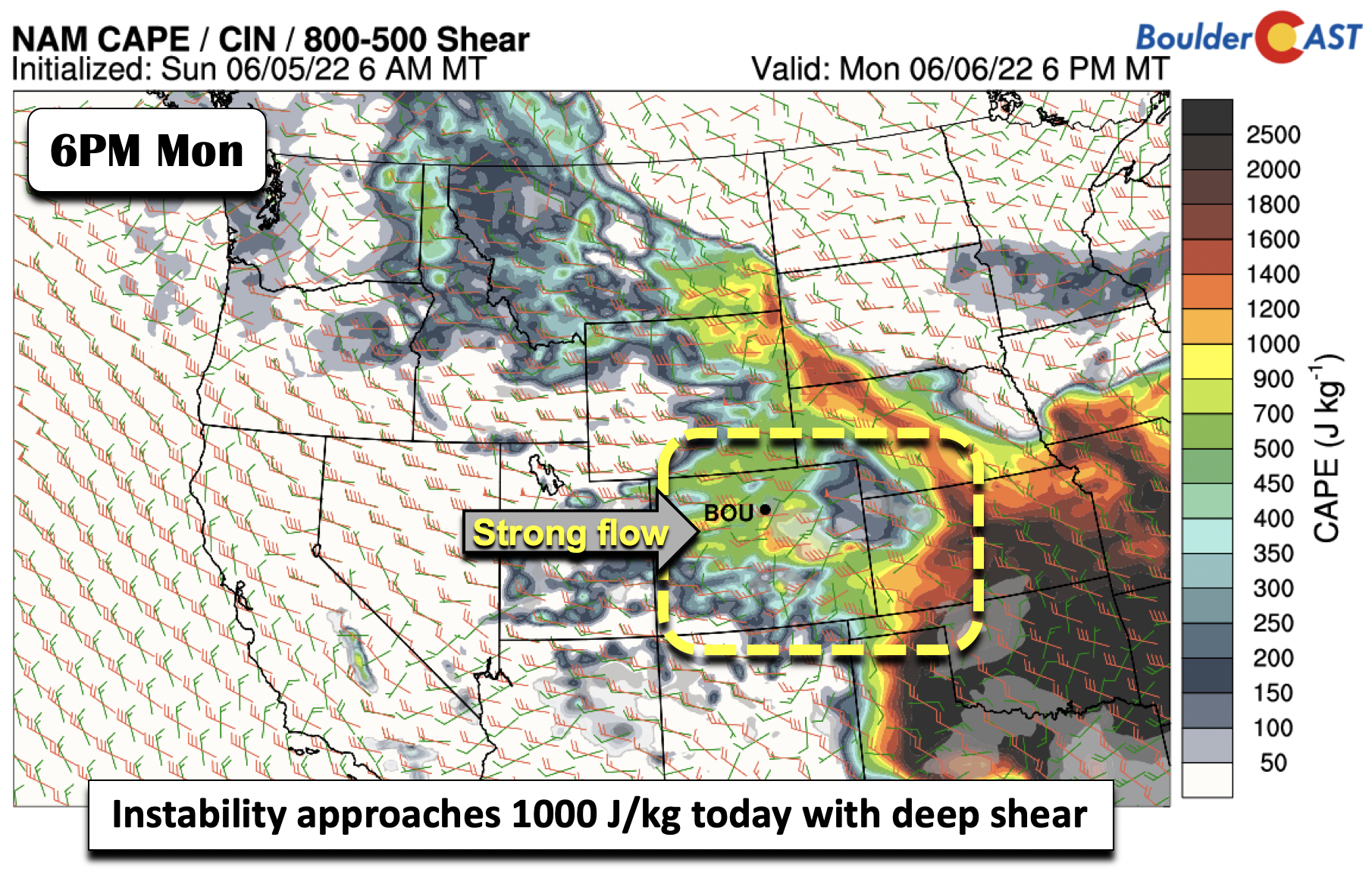
The primary severe threat today will be damaging winds and large hail. The strong westerly shear aloft will favor supercells given nearly straight hodographs. These straight hodographs usually also favor right/left moving supercells, where left moving ones are more apt to produce large hail.
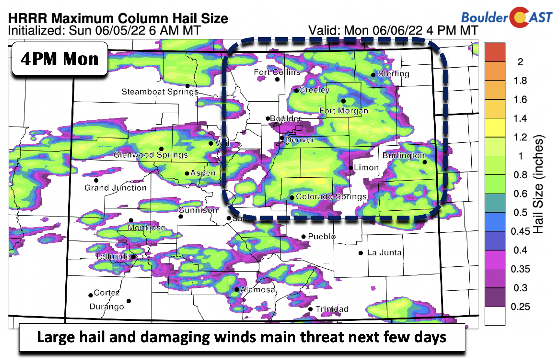
The best severe potential will be out east along the Kansas and Nebraska Borders where instability will be highest. However, gusty winds and frequent lightning will be possible over the Denver/Boulder regions given a pattern favorable of dry microbursts. Storm chances are about 40% today, with activity waning late tonight and overnight.

Severe weather outlook for Monday 6/6/22 from the SPC
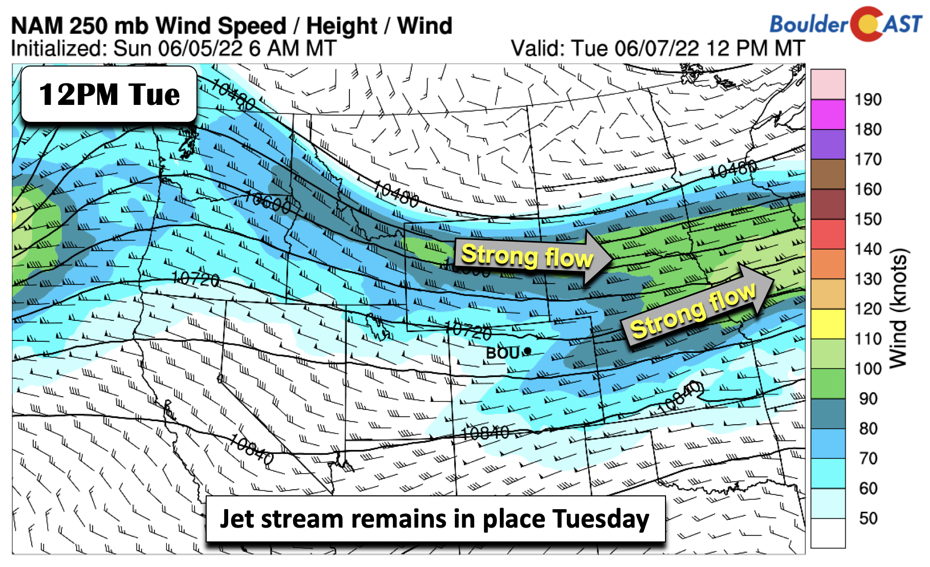
Tomorrow, the pattern changes slightly, but the overall specifics are similar. The upper-level jet stream will shift more toward the Mid-Mississippi Valley, but a jet streak will still extend into Wyoming and Colorado, placing eastern Colorado in a divergent area for enhanced lift.
At mid-levels, a main shortwave area of low pressure will reside over the Dakotas, with a shortwave axis extending southwest into central Colorado. The zonal flow will continue with highs in the lower 80s.
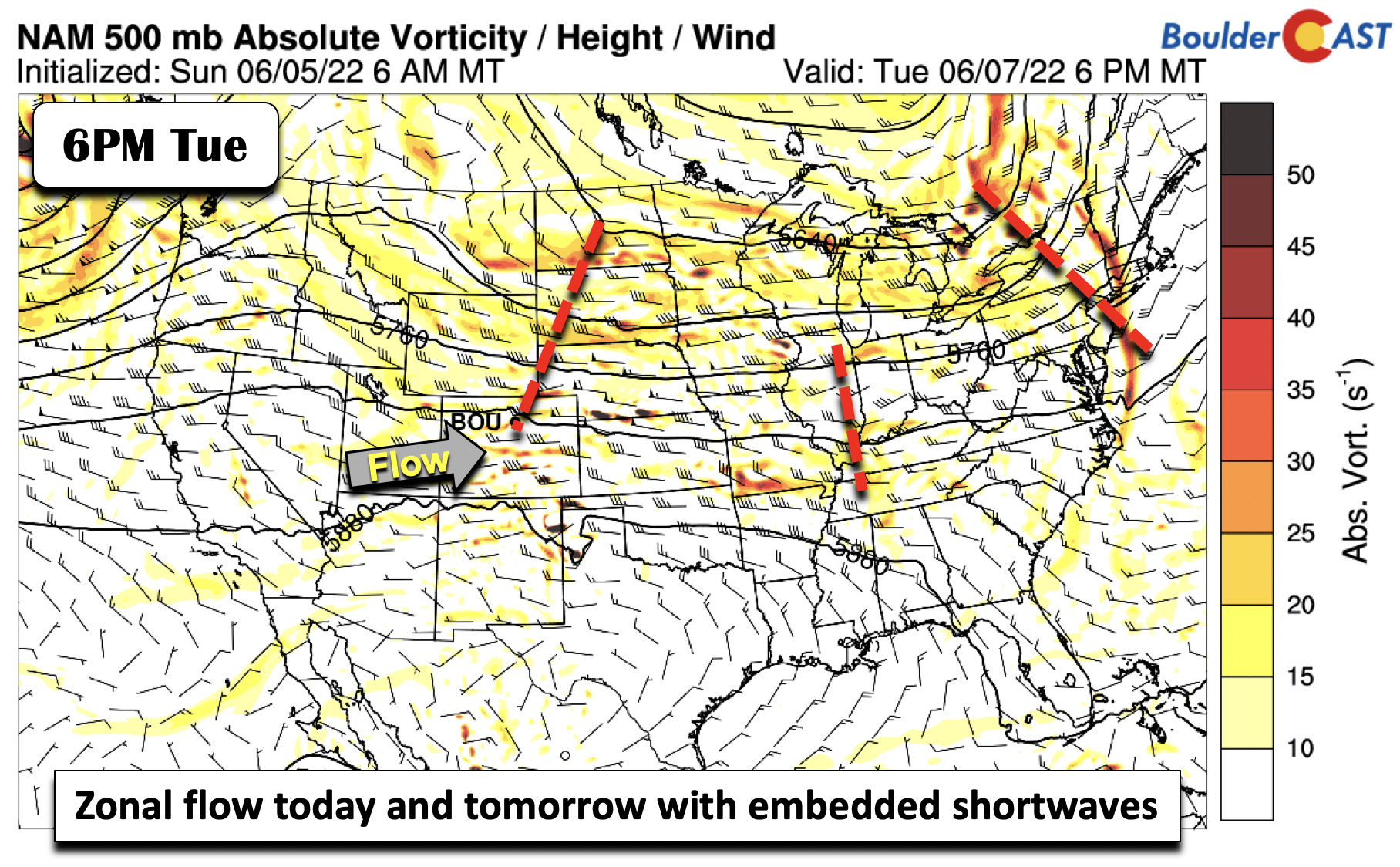
Associated with the trough to our northeast on Tuesday will be a southward moving cold front out of Montana/Wyoming. Ahead of the front, the unstable atmosphere will remain in place, with CAPE values rising to between 1000-2000 J/kg, greatest east of I-25. 
Deep-layer shear is about the same as Monday with westerly flow upwards of 40-50 MPH. This will again favor large hail and damaging winds as the primary threats on Tuesday. Storm chances Tuesday will be in the 20% range, highest east of I-25 and the Palmer Divide.

Severe weather outlook for Tuesday 6/7/22 from the SPC
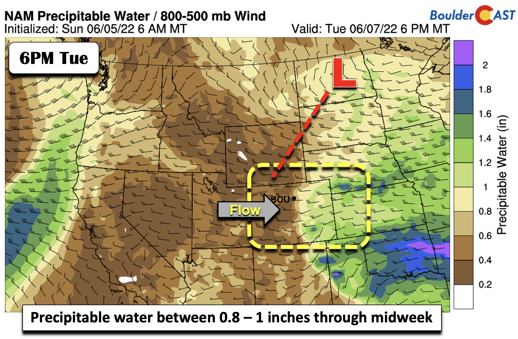
Precipitable water values will nearly approach one inch Tuesday, well above average for this early part of June. This will likely lead to scattered showers/storms that will grow upscale over east/southeast Colorado Tuesday night.
By Wednesday, most guidance shows that the trough to our northeast slides away further into the upper Mississippi Valley. Meanwhile, a ridge of high pressure starts to show up in Arizona. The ridge will not push east into our area until late in the week, however.
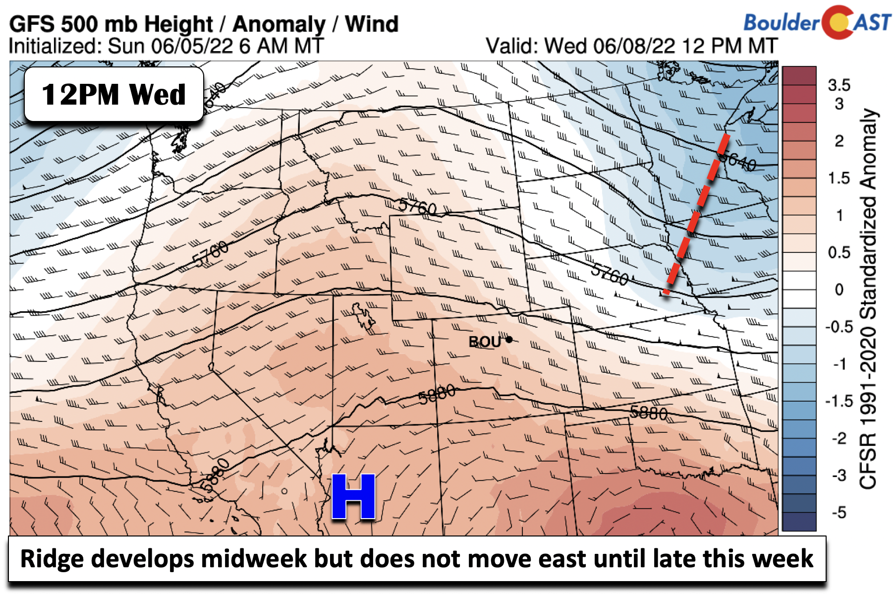
The trough passage to our east Wednesday will allow the cold front to slide through Wednesday morning and settle along the Foothills through the day. High pressure in its wake will set up over Kansas. This pattern will propagate our highs staying near normal in the upper 70s to low 80s, as the hottest air stays in Arizona and New Mexico with the strong ridging there.

Shear and instability will be a factor again on Wednesday. And with the front nearby with upslope surface flow, cannot rule out showers/storms once again in the afternoon/evening. It would appear the best chance of storms Wednesday would be along/south of I-70, closer in proximity to the instability axis. Storm chances will be about 10-20%.

Storm chances lessening by week’s end with above average temperatures
Model guidance is in general agreement that the front on Wednesday will lift back north Thursday, allowing the hot weather to our southwest to build into the state. Thursday will likely be our warmest day with upper 80s to near 90 degrees. Isolated storms will be possible, but only about 10-20% as forcing appears to be better focused over the Nebraska/South Dakota region.

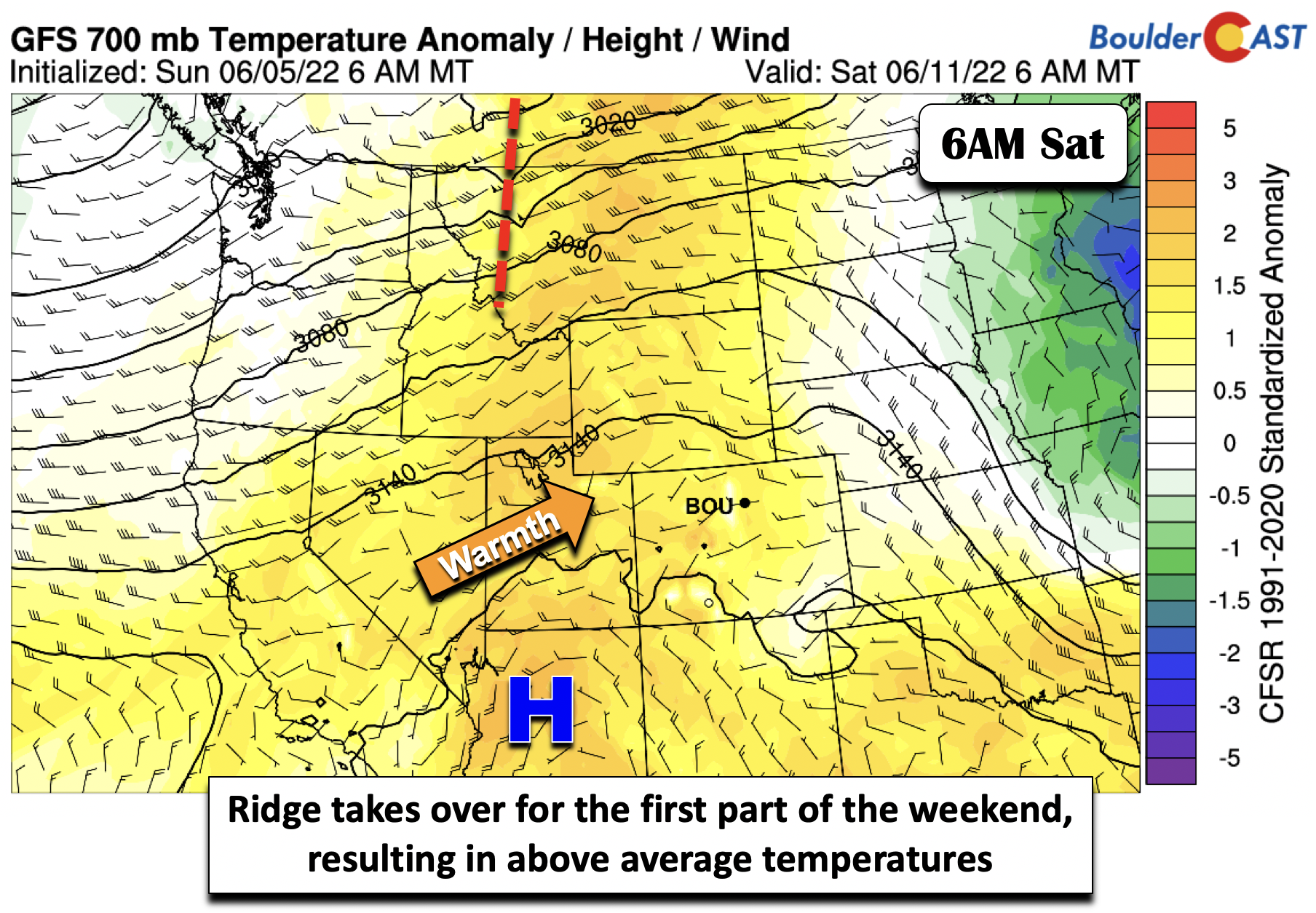
By Friday, there is good consensus that the front will then sag back south, moving through the Front Range early in the morning, with highs staying above average but cooler in the middle 80s. The nearby frontal boundary will continue a slight chance of afternoon/evening storms, roughly 10-20%. However, this should be the driest day as the ridge to our southwest starts to edge into the area, leading to a more stable atmosphere.

The ridge is expected to fully move over the state on Saturday, with the well above average temperatures moving in. Highs should be well into the 90s on Saturday. We can’t rule out a chance of some storms with a few weak impulses, but the better shot may be late Sunday with a potential pattern shift and approaching trough from the west-northwest.
Have a good week and get ready for the heat!
Stay up to date with Colorado weather and get notified of our latest forecasts and storm updates:
Forecast Specifics:
Monday: A few morning clouds, then some sunshine, then increasing clouds with scattered showers and storms for the late afternoon and evening. Highs in the lower 80s on the Plains and lower 70s in the Foothills. Storms could be severe with damaging winds and large hail well east of Denver.
Tuesday: Partly sunny with afternoon/evening isolated thunderstorms, some turning severe just east of the Denver Metro. Highs near 80 degrees on the Plains and upper 60s in the Foothills.
Wednesday: Partly cloudy with late-day isolated storms, some possibly being severe well southeast of our area. Highs in the upper 70s to lower 80s on the Plains and upper 60s in the Foothills.
Thursday: Much warmer with a slight chance of afternoon/evening storms. Highs in the upper 80s to near 90 for the Plains and upper 70s in the Foothills.
Friday: Warm and sunny with a slight chance of isolated afternoon/evening storms. Highs in the middle 80s to upper for the Plains and lower 70s in the Foothills.
High Country: There will be the chance of afternoon/early evening showers/storms over the higher terrain each day this week. However, the best chance of storm activity will be the first half of the week, Monday into Wednesday. Less storm chances will exist Thursday and Friday.

Help support our team of Front Range weather bloggers by joining BoulderCAST Premium. We talk Boulder and Denver weather every single day. Sign up now to get access to our daily forecast discussions each morning, complete six-day skiing and hiking forecasts powered by machine learning, first-class access to all our Colorado-centric high-resolution weather graphics, bonus storm updates and much more! Or not, we just appreciate your readership!
Spread the word, share the BoulderCAST forecast!


You must be logged in to post a comment.