After a rather humid, sticky week and weekend, the weather will shift Monday with winds and drier air persisting through the first half of the week. Afternoon thunderstorm chances are quite low, but increase towards the weekend with a major pattern shift in store for the weekend which could bring some moisture and a drop in temperatures.
This week’s highlights include:
- Nighttime lows return to more comfortable temps as humidity decreases, giving us better chances to cool our homes at night early this week
- Highs in the upper 80’s this week with Tuesday as the coolest day until a break from the heat next weekend
- Monday and Tuesday will come with gusty winds and drier air
- Chances for Thunderstorms increase later in the week with potential for some real monsoon moisture potentially moving in Saturday and Sunday
DISCLAIMER: This weekly outlook forecast is created Monday morning and covers the entire upcoming week. Accuracy will decrease as the week progresses as this post is NOT updated. To receive daily updated forecasts from our team, among many other perks, subscribe to BoulderCAST Premium.

A dry start gives way to potential weekend moisture
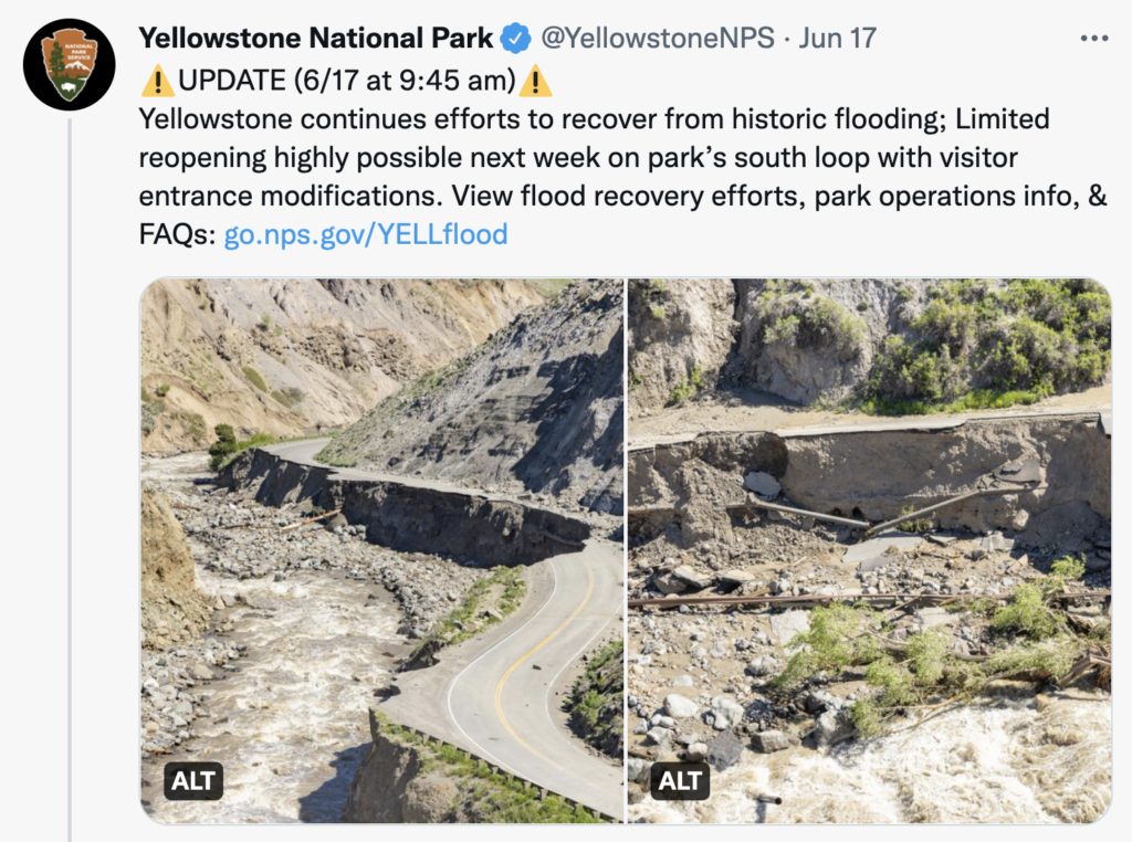
Our neighbors to the north in Yellowstone National Park experienced an historic 500 year flood last week, temporarily closing the south side of the park, but the north side will remain closed through the season. As we remember from our 2013 flood, it takes a long time to rebuild those roads and bridges eroded by intense creek/river flooding! In an attempt to reduce crowds, they’ll allow even license plates in on even days, odd on odd days after they partially reopen the south side this Wednesday.
An interesting comment from an article on the event says, “While there have been La Ninas like this one throughout the past, we’ve never seen in human history persistent La Nina events with global temperatures this warm before. That is a unique combination.” At the risk of oversimplifying, remember the awful dry spell we experienced in May in April? Well many of the systems we’d hoped to bring us snow during that time ended up bringing heavy precipitation to our north and this type of northern-shifted storm track pattern is typical of a La Nina, the anomalous cooling of the eastern equatorial Pacific. This wacky, persistent La Nina is predicted to continue. The reference to warmer global temperatures alludes to the thermodynamic concept that warm air simply has room for more moisture than cooler air, so a one degree increase in global average temperatures can increase moisture in the atmosphere by 7%, on average. This can lead to heavier snow and rain events. This, combined with a pretty quick June warm-up melting snowpack, all contributed to the setup for an extreme flooding event, changing plans for parks tourists and causing extensive damage to the park.
Back to the Front Range, the past week brough intense heat, smoke from Arizona, high humidity, a great lightning show, flash flood warnings in the Cameron Peak burn scar, and some spotty precipitation. Saturday night we didn’t drop below 70 at Boulder airport, making it one of several nights where opening the windows at night just didn’t pay off in much cooling. This week should give us more regular chances to cool our homes down after dark with lower humidity and clearer skies.
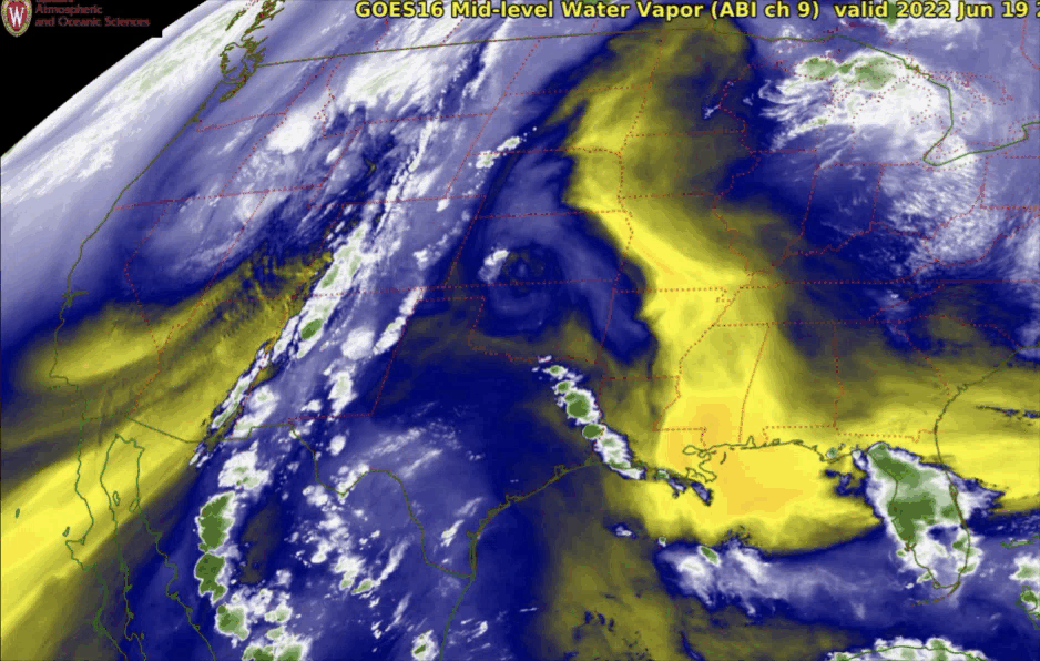
Sunday a few rounds of moisture came through, forced by the trough to our west and the ridge to our east pulling some of that subtropical moisture into the region, as seen in this mid-level water vapor satellite loop Sunday afternoon.
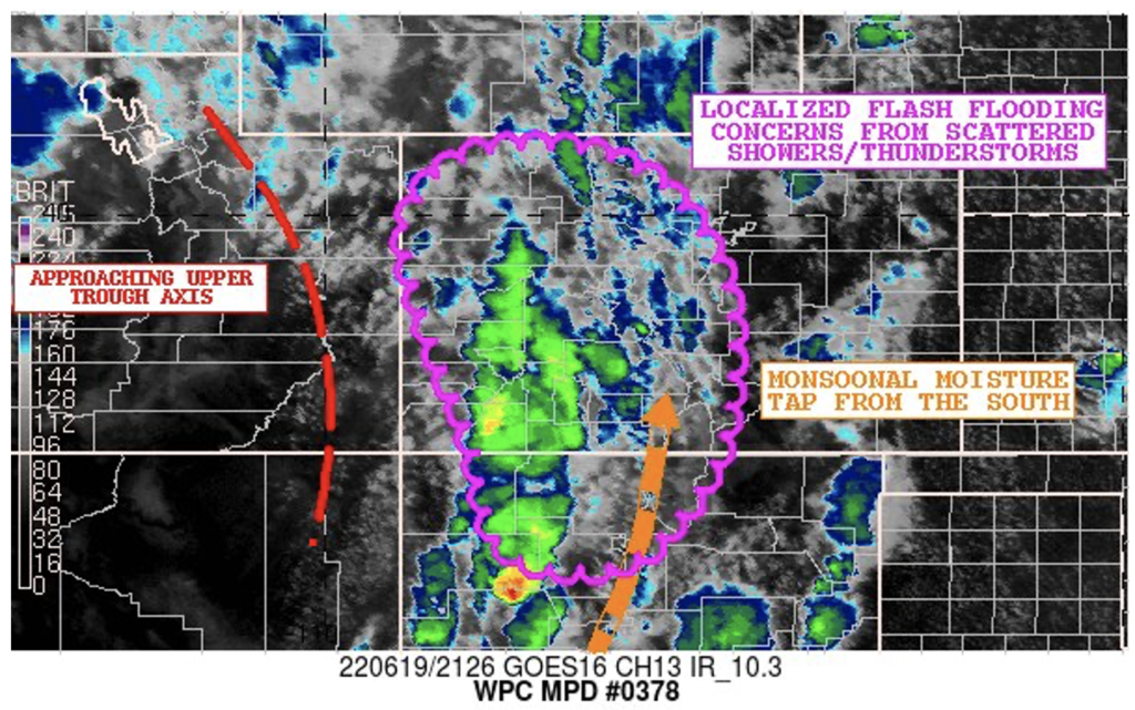
The NWS Weather Prediction Center annotated an image for us indicating these features and their concern about flash flooding, especially over burn scars like Cameron Peak.
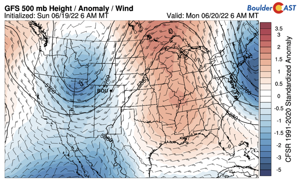
Monday this trough to our west lifts to our north contributing to some windy, but dry conditions. Winds will be out of the west. This brings with it a dry summer cold front to push through Monday night. Although it will be windy and dry Monday and Tuesday, wildfire fuel remains low after a few rounds of previous storms, keeping wildfire risks low, but seemingly never zero these days.
Monsoon moisture is forecast to stay mostly to our south during the week, but chances of increased moisture and instability meandering into the Front Range region ramp up from Thursday through Sunday with our best chances for more rain and thunderstorms Saturday and Sunday as our pattern shifts.
Stay up to date with Colorado weather and get notified of our latest forecasts and storm updates:
Forecast Specifics:
Monday: Sunny with a high around 86, dry, windy. A cold front comes through Monday night, making way for a low in the low 50’s.
Tuesday: High in the low 80’s, dry, less windy than Monday, and another cool night in the mid 50’s.
Wednesday: High around 86, very small chance of afternoon thunderstorms, overnight low a bit warmer in the lower 60s.
Thursday: High of 88, chances for thunderstorms start to creep up.
Friday: High of 88, a disturbance may come through Friday, increasing chances of thunderstorms.
Saturday and Sunday: Much higher chances for some precipitation and thunderstorms with a break in the heat.
Help support our team of Front Range weather bloggers by joining BoulderCAST Premium. We talk Boulder and Denver weather every single day. Sign up now to get access to our daily forecast discussions each morning, complete six-day skiing and hiking forecasts powered by machine learning, first-class access to all our Colorado-centric high-resolution weather graphics, bonus storm updates and much more! Or not, we just appreciate your readership!
Spread the word, share the BoulderCAST forecast!


You must be logged in to post a comment.