
A rather quiet week is in store for the state. There is really only one system passing through after one exits today. The rest of the time we will be under high pressure. That should allow for very pleasant weather overall, even in the Mountains.
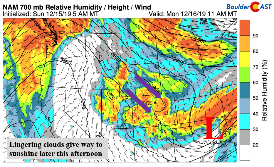
Lingering clouds taper off to sunshine
Yesterday’s trough system (below) has moved off into the state of Oklahoma. It is bringing rain/snow/freezing rain to the Midwest and will eventually move into the Ohio Valley. For us, the system is long gone and northerly flow is all that remains. High pressure will be building from our west but not fully until tomorrow. Lingering moisture and humidity about 5000 feet up will lead to a cloudy start today, followed by gradual clearing as the afternoon wears on. Temperatures today should be rather close to yesterday with highs in the lower 30’s thanks to a similar cold airmass over the state.
A warming trend through Friday (brief lull Thursday)
From about Tuesday onward, with the exception of Thursday, a warming trend will be the norm across Colorado and the Western United States. Below shows the mid-level height anomaly pattern (top panels) for tomorrow and Wednesday, as well as the near-surface temperatures (bottom panels) for the same time frame. As you can see, high pressure more or less anchors itself over the region these next few days. Notice also the area encircled in orange in the temperature panels. Watch how our temperatures become orange and yellow by midweek…a sign of downslope warming under the ridge of high pressure. Highs should go from the lower 40’s to the middle 50’s on Wednesday under sunny skies.

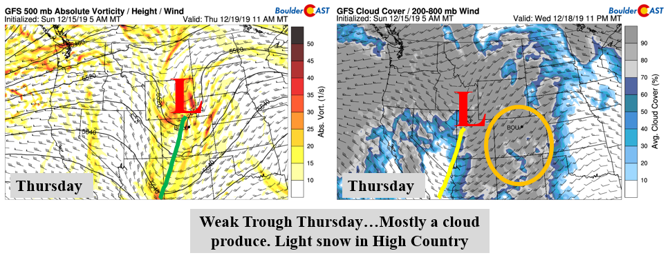
We mentioned one fly in the ointment…Thursday. A weak trough moves onshore from California during the day on Thursday. Its placement is shown in the GFS model below. The trough axis moves through more or less around midday. Most of this system will only bring clouds to the state. Some light snow is likely across the Mountains along and west of the Divide. But further east, downslope is king once again. The airmass cools slightly as well on the Plains…and with cloud cover (below right) on the increase, highs to be a tad cooler than Wednesday in the lower 50’s.
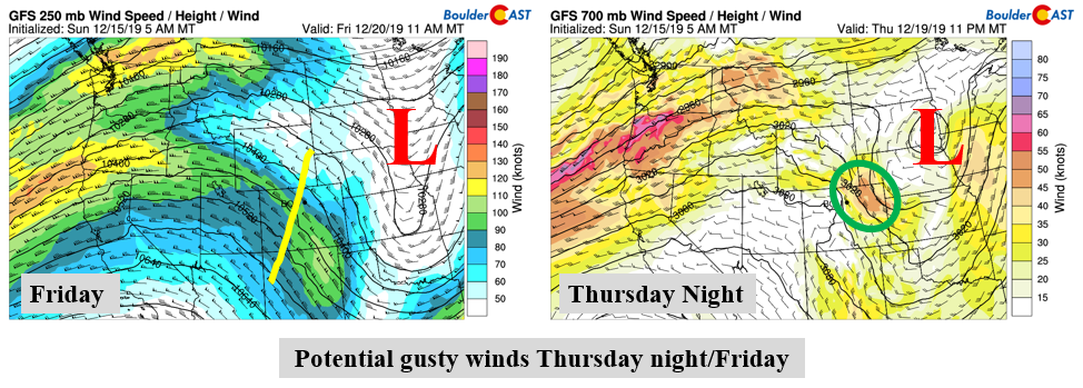
As we shift from Thursday night into Friday, the ridge rebuilds for a warm and sunny end to the week! But that transition may be felt by more than just the warmth and sunshine. We may have to deal with some gusty winds overnight Thursday into early Friday. The jet stream (below left) is positioned northwest to southeast over the Front Range. While not ideal, corresponding winds are found 5,000 feet up (below right), along with a tightening height/pressure gradient. It’s too far out to make any predictions at this point, but just know that this is on our radar.
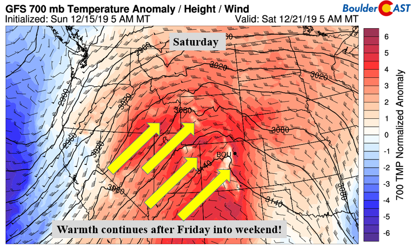
A gorgeous weekend
The warmth on Friday soars into the weekend. The actual ridge appears to strengthen even further, pushing in well above average temperatures for the entire Colorado/Utah/Wyoming/Nevada region. We would not be at all surprised if temperatures were well into the 60’s to maybe near 70? It looks great to say the least for December!
Forecast Specifics:
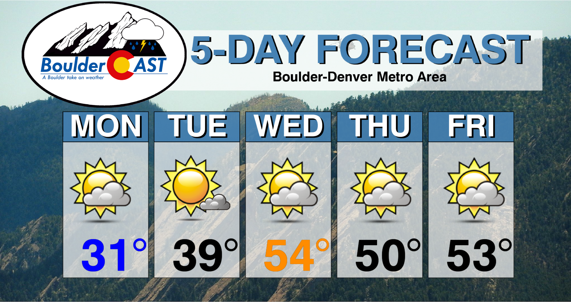
Monday: Decreasing clouds and chilly. Highs in the lower 30’s on the Plains and middle 20’s in the Foothills.
Tuesday: Mostly sunny and warmer. Highs in the upper 30’s to lower 40’s on the Plains and lower 30’s in the Foothills.
Wednesday: Increasing high clouds and pleasant with middle 50’s for the Plains and lower 40’s in the Foothills.
Thursday: Partly cloudy and slightly cooler than Thursday with upper 40’s to lower 50’s on the Plains and upper 30’s in the Foothills.
Friday: Partly to mostly sunny and pleasant with low to middle 50’s on the Plains and near 40 for the Foothills.
High Country: It’s going be a rather dry week for the mountains and ski resorts. Our next chance of measurable snow, albeit little, is Wednesday night/Thursday. At most, it looks like only a few inches at best. Gusty winds are likely Thursday into midday Friday. Check our PowderCAST page for always-updated weather forecasts for all of Colorado ski resorts.
DISCLAIMER: This weekly outlook forecast is created Monday morning and covers the entire upcoming week. Accuracy will decrease as the week progresses as this post is NOT updated. To receive daily updated forecasts from our team, subscribe to BoulderCAST Premium.

.
Spread the word, share our forecast!


You must be logged in to post a comment.