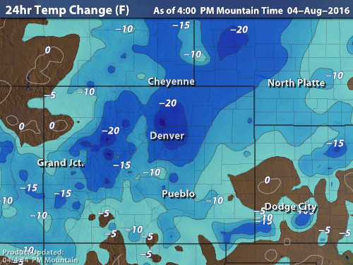
Cooler weather and beneficial rains are spreading across the Front Range as monsoon moisture collides with a cold front on our doorstep. Continue reading for rainfall amounts, timing, and when to expect that brutal August heat to return.
Tag: arvada (Page 8 of 12)
The last seven days have been quite dry across Boulder and the Denver Metro. We have also seen swings in temperature from the 90’s to the 80’s with a few frontal systems. This first week of August will start off warm in the 90’s, with a transition to cooler weather by week’s end. Wait until you see how chilly we are forecasting for Friday! Thunderstorms will be possible each day, although our best shot appears to hold out until the end of the work-week. Read on for this week’s full forecast.
Over the course of the last week, we’ve seen the beneficial summer rains spread across much of the Denver Metro area. The week ahead will see the plume of monsoon moisture shift westward, bringing a period of temporary drying to our region. Read on for all the details, including the extent of the heat and when we think the monsoon rains will ramp back up.
After a very dry stretch through much of July, this week will feature a strong shift in the weather pattern that will allow for monsoonal moisture to spread in from the southwest, leading to chances for thunderstorms each day. Outside of the storms, temperatures will also warm each day with highs climbing back into the 90’s. Read on for our full forecast and which days we expect the best likelihood of monsoon rainfall.
This afternoon’s thundershowers were a welcomed reminder of what July in Colorado could and should be like, weather which we have been hoping for over the last few weeks. Thankfully, Mother Nature has a few promising changes in-store for the near-future, beginning early next week with the resurgence of monsoon moisture to the region.
After a weekend filled with sunshine, heat and wildfires, the week ahead will feature a slight cool-down across northern Colorado as zonal flow takes center-stage. With this, rain chances will be minimal and confined to the end of the week. Continue reading for a recap of the recent dry weather and our complete forecast for the upcoming week.
Both Denver and Boulder are chasing record highs today. 99 is the number to beat in Denver, 100 in Boulder. We are forecasting 99 degrees in both cities today.
Fire danger will be high as well this afternoon, especially in the Foothills where Red Flag Warnings are active. A combination of hot temperatures, low humidity, and gusty southwest winds will breed volatile conditions for the rapid spread of fire. Luckily, there is no chance of lightning today, so any ignitions will require a human.
Therefore, please take extra precaution. We already had careless folks destroy several hundred acres of Boulder County forest yesterday…
With Independence Day now upon us, summer is in full-swing across the Front Range. We discuss the weather-week ahead (spoiler: it’s going to be hot!), and give our thoughts on when those monsoon rains might finally show up.
© 2025 Front Range Weather, LLC





You must be logged in to post a comment.