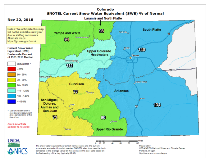
Heavy mountain snow is on the way for the weekend. We discuss the ski forecast and look at why any precipitation across the lower elevations will be limited.
The active pattern change we covered five days ago is now in progress. A weak storm system moved across Colorado yesterday, spreading heaps of wave clouds across the Denver Metro area, and light snow accumulations in the Mountains for the Thanksgiving holiday. Most of the ski resorts reported anywhere from 2 to 6″ inches of snow from that storm.
A second, stronger storm will move in Colorado later tonight and Saturday. In the infrared satellite animation below, this secondary storm can be seen as the spin coming ashore near Seattle, with a Pacific cold front trailing south into northern California.
The current radar shows that before reaching Colorado, this storm is greatly helping the wildfire efforts.
The 500 mb map below shows the storm’s track over the next 24 hours into Colorado.
This Pacific system will bring moist northwest flow to the state, leading to heavy snow in the Mountains. Models indicate this plume of moisture arriving around midnight Friday night, with moderate to heavy snow continuing in the Mountains through Saturday evening. There is good agreement for anywhere from 6 to 15″ of powder by Sunday morning.
If you’re planning to ski, Saturday will have heavy snow falling throughout much of the day and it will be very blustery with gusts of 55+ mph possible. Shown below is our latest PowderCAST forecast. All but the most southern resorts will see a healthy dumping of powder on Saturday.
Sunday will be colder, but it will be mostly sunny with much tamer winds. It’s your choice on which day’s weather and snow conditions are more preferable, or even better….ski both days!
Across the lower elevations, this weekend will be much quieter. That juicy northwest flow won’t do much of anything for us; it will be downslope into the Metro area. Therefore, despite the decent fetch of moisture and favorable upper-level dynamics, we’re not expecting much more than a few isolated rain and snow showers to reach Boulder and Denver. The meteogram below depicts no upslope in Boulder at all. In fact, it has strong west and northwest winds all day Saturday near and well above ground-level.
However, we can’t fully rule out rain/snow showers Saturday afternoon and evening. Thus we will include a chance of about 10 to 15%, mainly east of Interstate 25 where downslope won’t be as intense. Any snow across the Plains will be brief and should not amount to much. Some spill-over snow into the higher Foothills will be possible through the day Saturday with a couple of inches of accumulation in favored locations like Estes Park, Allenspark, and Ward. Even Eldora should catch enough spill-over moisture to pick up some good snow.
Our snowfall forecast map for the weekend is shown below. Again, we stress that most of the wintry impacts this weekend will be above 9,000 feet and anywhere west of the Continental Divide. Travel could become down-right treacherous on the mountain passes during the afternoon and evening Saturday, with even some road closures possible.
As far as temperatures, we should be able to quickly warm into the middle 50’s Saturday before the Pacific cold front surges through around mid-day. After this, expect falling temperatures into the 30’s the rest of the day with blustery northwest winds making it feel very chilly. We’re thinking that winds may gust above 50 mph during the afternoon and evening hours, slightly stronger than those on Friday. On Sunday, temperatures will top out near 40 degrees with sunshine returning.
Share this forecast:
.


You must be logged in to post a comment.