Category: Winter Weather (Page 86 of 139)
These posts contain some discussion of the white stuff, whether it be mountain snow pack or a Front Range snowstorm.
Our low-confidence snowfall forecast ended up turning out okay in most areas on Wednesday. This is despite a huge convective snow squall throwing a wrench into things late in the afternoon. Read on as we discuss what happened and review the totals from the snowfall event, which by the way was our fifth in just the last ten days.
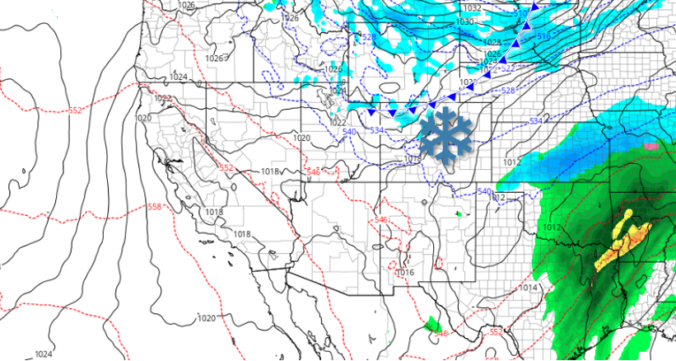
Models finally came into a snowy agreement last evening and unfortunately this means we have another round of snow to deal with Wednesday afternoon and evening, one which may turn out quite similar to what transpired on Monday. Read on for our full forecast, including when the snow will start and how much to expect in your area.
With the conclusion of last night’s quick-hitting snow event, our fourth in just the last eight days, Boulder has now officially eclipsed the typical amount of snow that falls in an entire season, and we’re not even half way through the month of February! We take a look at how this fits into Boulder’s history, what it might tell us about the potential for snow the rest of the winter, and give a quick and dirty forecast for our next chance of snow coming on Wednesday.

We continue the wintry stretch of weather to start the week with yet another round of accumulating snow. A slow warming trend then takes hold through the rest of the week. Could there also be another late week snowstorm? Read on to find out more!
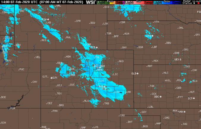
Pockets of jet-forced snow began to fall Thursday evening and continued intermittently through Friday afternoon across the Metro area. Bands of moderate to heavy snowfall were most prevalent near and south of Interstate 70 in the Denver Metro area and in the Foothills of Jefferson County where 8-16″ of snow was reported.
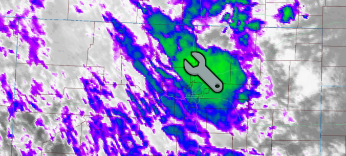
We take a quick peek at snowfall totals as of Friday morning, check the latest from the models, and let you know how much snow is still to come.
Following hot on the heels of the snowstorm earlier this week, another round of winter weather is expected Thursday evening into Friday evening across the Front Range. This one however will be a different beast, defined almost exclusively by a long window of scattered jet-forced heavy snow bands. Extreme uncertainty in the exact location and timing of the banding means potential snowfall amounts are not quite known. We discuss the setup and give our thoughts on what is sure to be a difficult forecast to end to the work-week.

Live View of Boulder

Current Conditions

Live Radar

Recent Premium Posts

This Weekend in Colorado Weather: Early-Season Heat Ramps Up — First 90s of the Year on the Horizon
🌬️ West–northwest flow Thursday supports high‑based convection with gusts to 35 MPH; virga …
BoulderCAST Daily – Wed 06/03/26 | Scattered P.M. storms again as moisture peaks for the week
🌬️ Weak westerly flow aloft today with no major synoptic features nearby; only …
BoulderCAST Daily – Tue 06/02/26 | Storms Reload This Afternoon, But With Noticeably Less Bite
❄️ Monday delivered lots of hail to northeast Colorado, with one supercell tracking …
3-Day Forecast

Trending Content

© 2026 Front Range Weather, LLC