Category: Premium Content (Page 258 of 452)

This content is for Premium Members only.

BoulderCAST Daily – Sun 08/30/20 | Warm and breezy with Red Flag conditions

Detailed Forecast Discussion We have one last warm day today before cooler weather moves in late tonight and tomorrow behind a mid-level trough. While yesterday was cooler than expected, the atmospheric flow this afternoon favors a much warmer day thanks to widespread downslope flow. Highs this afternoon should top out near 90 degrees. In the upper-levels (bottom left), a trough …

BoulderCAST Daily – Sat 08/29/20 | Cloudy with lower 80’s and a few scattered showers/storms

Detailed Forecast Discussion What a pleasant day it was yesterday with upper 70's. Today, the airmass over Colorado warms up. However, with extensive clouds moving in from the west-southwest, temperatures should only peak out in the lower 80's, so still a nice day overall. In the upper-levels, we have a weak disturbance tracking through in association with a jet streak …

BoulderCAST Daily – Fri 08/28/20 | Cold front one passed through with lower 80’s and storms

Detailed Forecast Discussion Gorgeous weather in store on this Friday! A cold front slid through from the north early this morning, leaving behind a much cooler airmass. Temperatures this afternoon will reach the lower 80's across the Front Range (below) under northeasterly winds, though it will feel like the upper 70's given our dry climate. We start off sunny but …

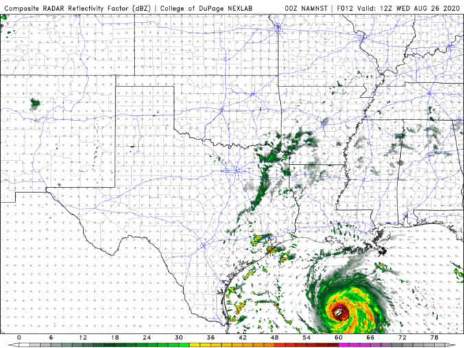
BoulderCAST Daily – Wed 08/26/20 | The ridge weakens, Laura makes landfall tonight

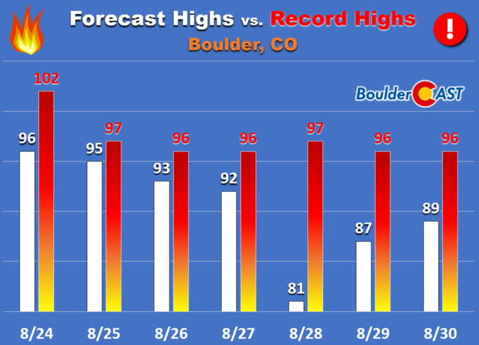
TDetailed Forecast Discussion emperatures once again soared into the middle to upper 90's across the Front Range Tuesday afternoon. There were even some triple digits further east in the South Platte River Valley. For the third consecutive day in a row, Denver International Airport reported a high of 98°F. We recorded a peak temperature of just 95°F at BoulderCAST Station …

BoulderCAST Daily – Tue 08/25/20 | Heat continues with isolated storms

TDetailed Forecast Discussion he persistent and stagnant high pressure center is located across far southwestern Colorado today with a long, tilted ridge axis spanning from central Canada into Baja California. This will result in little change in the weather pattern from yesterday, with another very hot day anticipated with highs in the middle to upper 90's across the Front Range. …

BoulderCAST Daily – Sun 08/23/20 | Some clouds with middle 90’s

Detailed Forecast Discussion The remnants of tropical system Genevieve (below left) is bringing moisture into the western U.S. today. That moisture at the mid and high levels will be pushing eastward into Colorado through the day. As of this morning, there were already some clouds present along the Front Range and High Country. Expect those mid and high clouds to …

BoulderCAST Daily – Sat 08/22/20 | Another day of 90’s…clouds possible tomorrow

Detailed Forecast Discussion As you may have guessed, little change in the overall weather pattern on this Saturday. High pressure continues to sit right over our southwest (below). The airmass warms 1-2 degrees today, with the 700 mb (5,000 feet aloft) temperature near 21 degrees Celsius! That should put highs near the middle 90's over Denver and Boulder. It will …

« Older posts Newer posts »