

Category: Premium Content (Page 245 of 452)

This content is for Premium Members only.
BoulderCAST Daily – Tue 12/15/20 | Morning flurries, but afternoon sun

TDetailed Forecast Discussion: he snow-making system which brought light snow to the area overnight continues to push off to our south and east. It is currently located in northeastern New Mexico. This system will haul eastward to bring historic heavy snow to portions of the I-95 Corridor (Boston to Washington DC) in the coming days. In the wake, northerly flow …

BoulderCAST Daily – Sun 12/13/20 | Sunshine for a day before the next light snow event

Detailed Forecast Discussion: Last evening's snow event system has moved off already into Oklahoma and northeast Texas (below). In its wake, a weak ridge of high pressure has ensued across Utah and Colorado. That will bring calm weather this afternoon. But the atmosphere remains active, with yet another weak area of low pressure currently near northern California and western Oregon. …

BoulderCAST Daily – Sat 12/12/20 | Accumulating snow tonight

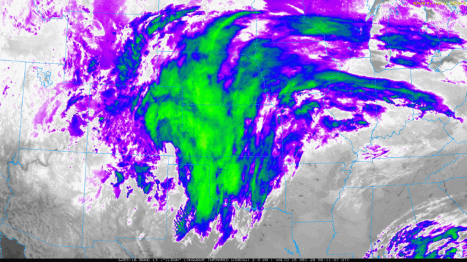
Detailed Forecast Discussion: As we have been talking about the last few days, there is a decent trough of low pressure that will be tracking through the region tonight, bringing snow to the Front Range. This time, the storm is a tad stronger than that which occurred 24 hours ago. The figure below shows this morning's Infrared Satellite image. The …

BoulderCAST Daily – Fri 12/11/20 | Light snow through tonight with highs upper 20’s

Detailed Forecast Discussion: Weak upslope flow today, as well as a moderately strong upper-trough will lead to scattered light to at times moderate snow showers into the evening hours. In the below image, the trough is currently located over central Colorado. This trough will slowly migrate eastward this evening. Overall, the forcing for lift is quite weak, with upslope flow …

BoulderCAST Daily – Thu 12/10/20 | Cool & cloudy with light snow developing tonight

TDetailed Forecast Discussion: oday will be cooler and cloudy as moisture begins to stream into the area aloft ahead of the storm system moving our way from the Desert Southwest. The GOES-East infrared satellite animation from this morning below shows the plethora of cloud cover associated with the approaching systems currently engulfing much of the western United States. The center …

BoulderCAST Daily – Wed 12/09/20 | The final warm & dry day, change comes tomorrow

ODetailed Forecast Discussion: ne more very warm day is expected today as the ridge of high pressure finally kicks eastward across Colorado and weakens in the process. Very dry air resides in the lower atmosphere across the Front Range with dew points in the single digits both above and below zero through the day. This magnitude of dry air at …

BoulderCAST Daily – Tue 12/08/20 | 60’s with uninterrupted sunshine

TDetailed Forecast Discussion: he rex block pattern which we first discussed with you last Thursday is STILL present across the western United States, a full five or six days later. We haven't noticed even a cloud in Boulder since sometime on Wednesday under this setup. Remember that a rex block is a persistent, protective pattern that occurs when a strong …

« Older posts Newer posts »
