Category: Premium Content (Page 221 of 452)

This content is for Premium Members only.

BoulderCAST Daily – Fri 07/02/21 | Another round of scattered showers/storms later today

ADetailed Forecast Discussion: nother round of some scattered showers and storms are expected later this afternoon and evening. Moisture has increased (will discuss in a bit), along with mid-level and low-level forcing for ascent. Over the nation today, high pressure is situated over the Upper Midwest, along with a weak trough axis west of the ridge from Montana into central …

BoulderCAST Daily – Thu 07/01/21 | The apex of storm chances for the week is today as monsoon season begins!

HDetailed Forecast Discussion: appy first day of July! Yesterday's flash flooding threat was realized across the Front Range, but storm coverage was less than expected with many areas remaining dry or reporting just a few sprinkles. A couple very slow moving thunderstorms did develop east of Fort Collins and Greeley producing localized flooding with 2 to 5" of rainfall dumping …

BoulderCAST Daily – Wed 06/30/21 | Scattered storms through the end of the week with elevated flood risk in the burn scars

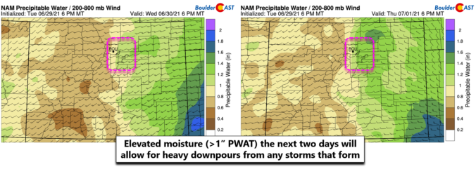
TDetailed Forecast Discussion: he going forecast remains on-track for an uptick in storm activity and intensity over the next few days as a surge of moisture arrives to the Desert Southwest and Colorado. The large-scale pattern is such that the clockwise flow around a high in Texas will team up with the counter-clockwise flow around a low pressure in Utah …

BoulderCAST Daily – Tue 06/29/21 | Clouds & sun with low storm chances, but wetter days ahead

TDetailed Forecast Discussion: he historic high pressure center will shift slowly from the Pacific Northwest eastward into Minnesota by week's end. This sluggish trek is shown in the GFS 500mb height anomaly forecast animation below. Notice that Colorado will be under a weak troughing pattern today but gradually transitions to weak ridging over the next few days. This will lead …

BoulderCAST Daily – Sun 06/27/21 | Little change from yesterday with another round of scattered showers later today

ADetailed Forecast Discussion: ll was quiet over the Front Range earlier this morning (below), as evidenced by the webcam over Boulder. Expect sunny skies to start our day, with temperatures rising closer to the lower 70's for the afternoon. The sunshine will give way to increased cloud cover for the afternoon and evening hours. The trough axis remains draped from …

BoulderCAST Daily – Sat 06/26/21 | Well below normal with rain showers expected again today

CDetailed Forecast Discussion: old front has pushed through last night and this morning it is located along northern New Mexico and eastern Kansas (below). The front is quite evident with the green and blue shading denoting below normal temperatures behind the front all over eastern Colorado. As a result, today's highs will be well below our average (typically in the …

BoulderCAST Daily – Fri 06/25/21 | Widespread showers/storms today

TDetailed Forecast Discussion: rough of low pressure today is situated over central North Dakota, with a trough axis oriented west to east over Colorado. This trough axis will be slowly pushing east this afternoon and evening, aiding lift for widespread showers and storms across the state. Along with the trough axis, a cold front will be pushing southward this evening …

« Older posts Newer posts »