Category: Premium Content (Page 194 of 451)

This content is for Premium Members only.

BoulderCAST Daily – Sat 02/12/22 | Starting cold with a blanket of snow, but 40’s this afternoon with sun

Booming snow totals were observed across much of the Denver Metro area last night, especially in Boulder and the nearby Foothills as moderate to heavy snow persisted almost continuously from the afternoon into the evening. The last official observation was ~9" in Boulder late last evening. This matches well with what we are seeing outside now and what is stacked …

BoulderCAST Daily – Fri 02/11/22 | Snow bands producing brief heavy snow develop by early evening

Model agreement, though still some differences, have come into much better alignment regarding the snow potential today into tonight. What is certain is that at mid-levels, a shortwave trough dives down out of Montana and Wyoming, taking a southward track through eastern Colorado as the day progresses. As this system does so, it will put the Front Range in a …

Weekend Weather Snapshot: February 10, 2022

After a few spotty light snow showers overnight, today will be pleasant and fairly warm by mid-February standards. GOES-East infrared satellite imagery this morning shows we are once again between rapidly-moving storm systems and that will be the case through today and most of tonight. The weak trough axis which brought the overnight snowflakes in spots has swiftly pushed south …

BoulderCAST Daily – Wed 02/09/22 | More clouds around with an isolated rain/snow shower tonight

Another weak clipper system will impact eastern Colorado today dropping in with the northwest flow.  The trough axis will pass through the Denver area around midnight tonight, with mainly just a notable increase in clouds expected for the Front Range. As we have been discussing all week, this system has very little moisture to work with, is moving rapidly, and …

BoulderCAST Daily – Tue 02/08/22 | Sunny, seasonal, and breezy

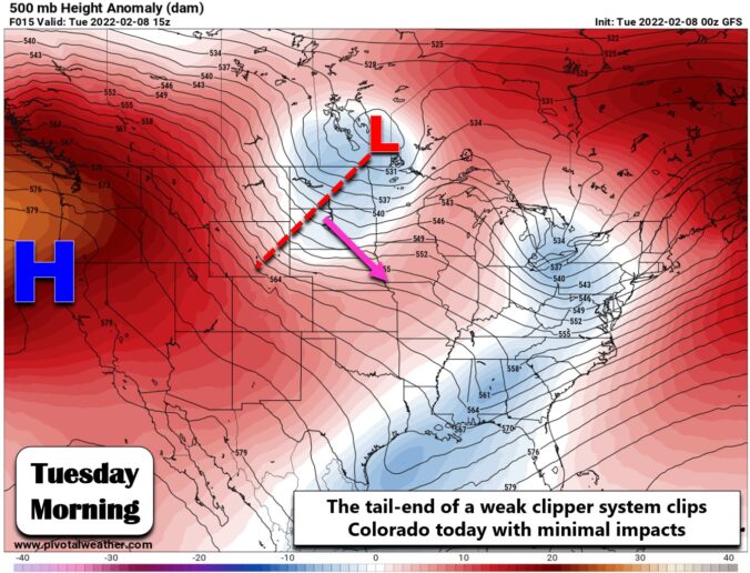
The tail-end of a weak trough axis is clipping through our area today. The parent storm is all the way up north of Minnesota this morning with the meager wave trailing back westward towards Wyoming. This feature shows up nicely on this morning's GOES-East infrared satellite animation --- and it isn't much to write home about. In our neck of …

BoulderCAST Daily – Sun 02/06/22 | Isolated snow showers in the morning becoming sunny and chillier

Amid-level trough is sinking south through the state today from central Wyoming. The track of the trough is somewhat unconventional, taking a more north to south track than toward the east-southeast. Nevertheless, it will favor a brief period of rising motion until roughly 11 AM this morning, increasing clouds and some widely isolated snow showers across the Front Range. The …

BoulderCAST Daily – Sat 02/05/22 | A tad breezy with highs in the middle 40s

It is National Weatherperson's day! Be sure to thank a fellow meteorologist you know, if you get the chance. A mid-level area of low pressure is situated off to our northeast in northwest North Dakota today. It will be tracking largely east-southeast and remain mostly to our north today, with the bulk of the lift remaining over the upper Midwest. …

« Older posts Newer posts »