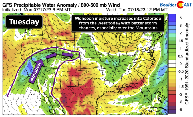
Ahuge mid-level ridge of high pressure remains parked off to our south across New Mexico today and this will remain the case most of the week ahead keeping us rather hot and fairly dry. This ridge will eventually drift a bit further south tomorrow allowing for some monsoonal moisture to enter Colorado from the west, ultimately fueling an upward trend …
The ridge has continued to shift eastward today and will stay in place tomorrow as well for the first part of the week. Low-level temperatures this afternoon will support middle 90s in most of the Denver Metro area. Expect mostly sunny skies giving way to some afternoon clouds. Tomorrow the ridge placement changes little and the airmass further warms. With …
The weekend will largely center on the return of warm to hot temperatures as a ridge moves east and envelopes much of Colorado. Today, that ridge will be over Utah/Arizona. By Sunday, it will be located over the Four Corners. The eastward progression will allow for highs in the upper 80s today and lower 90s on Sunday. Both days this …
Drier air from the north and west will advect into the area this afternoon with much lower precipitable water values relative to Thursday. Values will be near 0.6 to 0.8 inches compared to over 1 inch yesterday. As a result, it should be a much drier day across the Front Range. A day of plentiful sunshine should be the main …
Copius moisture is pooling over Colorado right now and we've already seen some thunderstorms early this morning move through our area from west to east. The current radar animation shows this early-morning batch of storms heading away from the Denver area as of 6:30AM. Plentiful monsoon moisture continues to surge into the region from the west, visible in this morning's …
Monsoon moisture will continue to funnel into the area today from the west-northwest with storm chances on the rise as a result. GOES-East water vapor imagery shows a solid pipeline of moisture stretching from Lake Tahoe, through Salt Lake City and into the Front Range. This moisture tap will continue for about 48 hours or so longer, maximizing during the …
Monday's official high temperature was 97°F in Boulder, one degree shy of the existing record high temperature for July 17th. This reading came just before a few high-based storm clouds rolled into the area and cut temperatures back down several degrees with cool outflow winds. The temperature graph below is from our unofficial BoulderCAST Station on Monday. Somewhat recirculated monsoonal …