It’s going to be a scorcher across the Front Range this week—with temperatures climbing fast and flirting with triple digits by midweek. But just as the heat peaks, a pattern shift arrives that will bring cooler weather and a chance of storms again by Friday. Read on for all our full outlook of the weather week ahead.
Category: Forecast (Page 9 of 164)

A shifting weather pattern is on the way as we head into the holiday weekend along the Front Range. Thursday will bring the heat and mostly dry skies, but things could get a bit more unsettled as we head into the Fourth of July and the weekend. If you’ve got outdoor plans in the coming days, here’s what to keep an eye on.

Monsoon season kicks off right on time this week, bringing a steady stream of moisture from Mexico into the Southwest and central Rockies. While daily storm chances are on tap for the Front Range, coverage looks hit-or-miss, with Wednesday shaping up to be the warmest and driest day. Expect highs ranging from the 70s to mid-90s as the pattern evolves. We also need to keep an eye on the forecast heading into Fourth of July weekend as scattered storms will be in the mix.
Colorado’s scorcher of a weekend is finally giving way to cooler, stormier skies—and not a moment too soon. After record-breaking highs in Boulder and Denver, a refreshing cold front kicks off the week with below-normal temps and a solid chance for showers and storms, especially Tuesday when things could turn severe. But don’t get too cozy—the heat will make a comeback late in the week into the weekend. Here’s what you need to know about Colorado’s weather during this final week of June.

Front Range Colorado is bracing for a scorching stretch ahead as a powerful heat dome settles in, sending daily highs into the 90s and even near 100°F come Friday. Fire danger is also set to rise with bone-dry downslope winds ramping up in the days ahead. But there’s relief on the horizon: a cold front will finally break the heatwave by Monday, bringing much cooler temps, a shot at rain, and the kind of weather we’ll certainly be ready for!
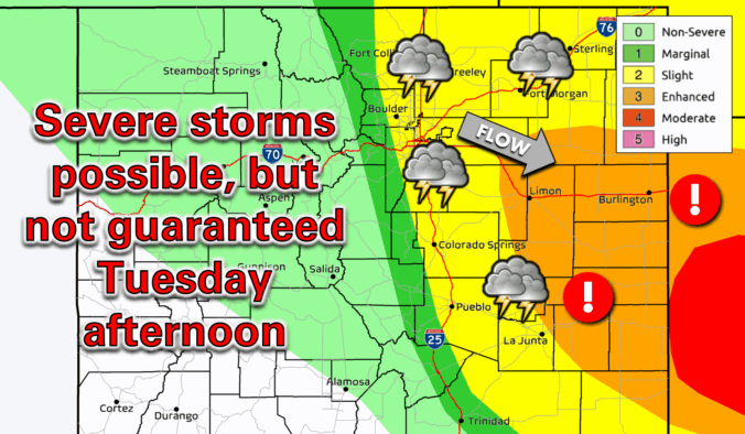
The anticipated reprieve from the heat has arrived! Low clouds blanket the Front Range Tuesday morning, and exactly how quickly they burn off today will be the key to unlocking explosive severe thunderstorm development this afternoon over our area. We discuss the latest forecast details surrounding the severe risk today, including our team’s lingering concerns, the timing of the risk, and which areas stand the best chance to see big hail Tuesday afternoon.
Record-breaking temperatures will be the story this week in the Front Range, though there’s plenty more to discuss. While a brief cooldown is on the way Tuesday, it comes with a catch—a chance for severe storms, depending on how quickly low clouds clear up. Then, just as we get a break, another scorching heatwave arrives on Thursday through the upcoming weekend, with several days of triple-digit temperatures that will shatter records. Let’s dive into the details.
Get ready for a classic early summer setup—plenty of warmth, a hint of storm potential, a bit of wildfire smoke, and maybe even the year’s first 90-degree day(s) for the Front Range. While the week starts off dry and sunny, a few scattered storms will make an appearance midweek, adding a little variety to the forecast. By the weekend, the heat cranks up as a strong ridge sends hot air northward into Colorado.

Live View of Boulder

Current Conditions

Live Radar

Recent Premium Posts

BoulderCAST Daily – Tue 02/10/26 | Much cooler for our Tuesday with rain/snow arriving into the Mountains by Wednesday morning
🌡️ After Monday’s 70° warmth, a late‑night cold front has brought an end …
BoulderCAST Daily – Sun 02/08/26 | Mild for Super Bowl Sunday
☀️ Mild through Monday: Highs in the mid 60s to low 70s through …
BoulderCAST Daily – Sat 02/07/26 | A few wave clouds today but still quite mild
☀️ Mild through the weekend: Highs in the mid 60s to low 70s …
3-Day Forecast

Trending Content

© 2026 Front Range Weather, LLC