Category: Forecast (Page 6 of 164)
The Front Range kicks off October with a stretch of warm, dry weather—perfect for leaf peeping and outdoor plans. After a brief chance of storms on Monday, highs climb into the 80s by midweek under mostly sunny skies. But this unseasonable warmth and sunshine won’t last forever: a late-week system could bring cooler temps and a renewed shot at rain or even Mountain snow. Read on for all the details.
This week’s weather kicks off with a dramatic autumn shift—widespread rain, clouds, and a serious temperature drop that will bring snow to the High Country. A strong cold front and upper-level system will make Tuesday feel more like late October, with highs stuck in the lower 50s. But don’t worry, sunshine and warmth are on the horizon again. By midweek, we’ll rebound into the 60s and maybe even flirt with 80 by Friday. Curious about how much soaking rain we’ll get—or where that snow might land? Read on for all the details.
After a sunny and warm start to the week, the Front Range will trade blue skies for gray as a sluggish low-pressure system settles into northeast Colorado for several days. Rain chances build Tuesday and linger through Thursday, with well below normal temps and a few rounds of storms in the mix. But don’t expect a soaking: rainfall totals may vary widely, with the heaviest action likely landing northeast of Boulder and Denver towards Nebraska. The storm exits sometime Thursday leaving behind drier and warmer weather for the weekend.

Last week’s cold front didn’t just drop temperatures—it dragged in a wall of chemical-scented smoke that turned the Front Range skies hazy and acrid. The days ahead are shaping up to be much more pleasant with warmer temps, limited storm chances, and a break from the smoke (at least for now) under southwest flow. Read on for a full breakdown of this week’s weather, including when to expect the best shot at rain and whether any smoke may return in the extended.
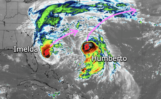
Thursday’s shaping up to be a busy weather day across the Front Range. We’re looking at hot temperatures, gusty winds, and a cold front arriving by evening that’ll bring a noticeable drop in temps — along with a wave of wildfire smoke. We’ll walk through what to expect today, how the weekend is shaping up, and whether any moisture from Hurricane Lorena might sneak into the region.
September kicks off with a mellow vibe across the Front Range — warm days and mostly dry skies are expected. But don’t let the quiet start fool you. Between drifting wildfire smoke, sneaky cold fronts, and a potential tropical system by the weekend, there’s more nuance in our forecast this week than meets the eye. Read on as we break down what to expect day by day, plus what might shake things up by the weekend.

Live View of Boulder

Current Conditions

Live Radar

Recent Premium Posts

BoulderCAST Daily – Tue 02/10/26 | Much cooler for our Tuesday with rain/snow arriving into the Mountains by Wednesday morning
🌡️ After Monday’s 70° warmth, a late‑night cold front has brought an end …
BoulderCAST Daily – Sun 02/08/26 | Mild for Super Bowl Sunday
☀️ Mild through Monday: Highs in the mid 60s to low 70s through …
BoulderCAST Daily – Sat 02/07/26 | A few wave clouds today but still quite mild
☀️ Mild through the weekend: Highs in the mid 60s to low 70s …
3-Day Forecast

Trending Content

© 2026 Front Range Weather, LLC