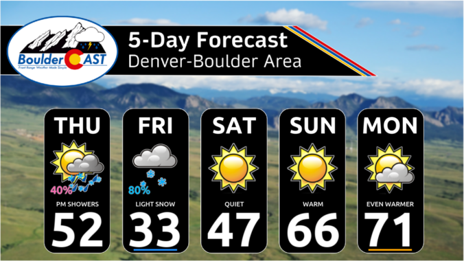
Two different low pressure systems will impact Colorado to end the work week, but unfortunately they will both largely miss the Front Range — one too far north and the other too far south. The Boulder-Denver area will still catch some light precipitation and colder temperatures, but potential snow accumulations are expected to be light and remain mostly west of Interstate 25 and in the Foothills. Things clear out nicely just in time for the weekend, with sunny skies and 70-degree temperatures not far off. Here’s the latest.
Category: Forecast (Page 14 of 163)
The month of March starts off like a lion in the Front Range with a few shots of snowfall headed our way. The first event will bring rain changing to snow Monday night accompanied by gusty winds and chilly temperatures. Travel will become very difficult across much of eastern and central Colorado Monday night into Tuesday with blizzard conditions in some areas, but Boulder and Denver will be mostly spared from this event. We’re also tracking another late-week system which could bring light snow to the area again. As for temperatures, they will oscillate up and down through the week with the passage of each system. Read on for the latest forecast details, including our snowfall forecast map for the impressive winter storm knocking on our door early this week.
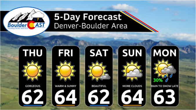
The last two weeks have been considerably colder than normal across the Front Range (thanks Flatiron Freddy!), but that changes this week as the atmospheric pendulum swings the other direction ushering in a welcomed pattern shift across all of Colorado. The week ahead will be largely dry in our area with temperatures well above normal every day except Wednesday. The beautiful conditions will continue through the upcoming weekend, but the first week of March will see a return of cooler and unsettled weather with rain and snow chances in tow.

Last night’s quick-hitting snowstorm hit with a bang in the southwest Denver Metro area and southern Foothills, with locally heavy snowfall up to 20″ falling in parts of Jefferson County. Elsewhere, snow amounts fell well in-line with our forecast, including some Front Range cities not receiving a single snowflake! We review how the storm unfolded, the snow totals from across the region and look ahead to the remarkably warm and sunny weather about to take center stage.
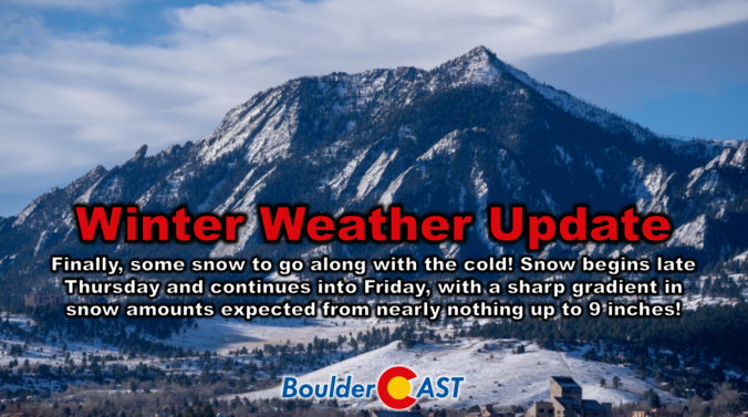
It’s been a brutally cold week in the Boulder-Denver area with temperatures remaining entirely below freezing since Saturday morning. Up until now, we haven’t had much snow to show for this Arctic plunge, but that changes later on Thursday as we finally get some moisture and a real storm system passing through to generate widespread snowfall across the Front Range. We discuss the latest forecast details, including how models have been trending the storm further south in recent runs which will make for a tricky forecast, one with a very sharp gradient in expected snowfall totals. Let’s take a look.

Live View of Boulder

Current Conditions

Live Radar

Recent Premium Posts

BoulderCAST Daily – Wed 01/21/26 | One last mild day before temperatures really begin to tumble
🌤️ Last mild day: Sunshine boosts temps to the upper 40s/near 50° today. …
BoulderCAST Daily – Tue 01/20/26 | The warmest day of the week comes with elevated fire danger, bitter cold and light snow still brewing for late-week
☀️ Warmest day of the week — Sunshine pushes highs into the low …
BoulderCAST Daily – Sun 01/18/26 | Quiet on Sunday but a low-end snow chance tonight
🌤️ A more quiet Sunday: Quiet for most of today as we reach …
3-Day Forecast

Trending Content

© 2026 Front Range Weather, LLC