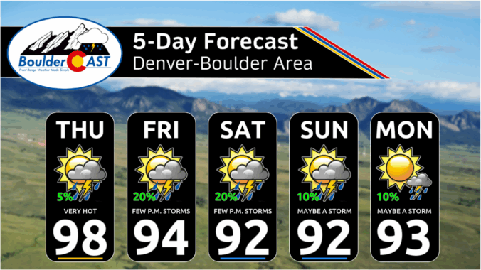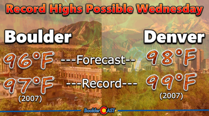
The Front Range is heading into a stretch of intense summer heat this week, with a dominant high-pressure system set to lock Colorado into several days of sizzling temperatures and dry skies. Expect highs in the mid to upper 90s every day through Friday. While Boulder isn’t guaranteed to break any record high temperatures, past patterns suggest we could run hotter than models are currently predicting—something worth watching as it would bump up the heat risks in the Metro area. Relief is on the horizon, though: a cold front late Friday should bring a sharp cooldown just in time for the weekend with at least low-end chances for storms returning.
Colorado’s monsoon season has been off to a sluggish start, and the latest surge storm potential this week isn’t even from the monsoon itself—it’s thanks to potent cold fronts dropping in from the northeast. In today’s update, we dig into why flash flooding is on the rise this week, which areas are most at risk, and what the next few days could mean for our thirsty landscapes. Spoiler: while heavy rain is possible, it’s only a short window and many of us won’t see it. Plus, the new blanket of wildfire smoke is likely to stick around through the weekend.
After a hot and mostly dry Monday, the Front Range is in store for a wetter stretch midweek, with an uptick in monsoonal moisture and storm activity. A favorable upper-air pattern and midweek cold front will drive daily thunderstorm chances and potential flash flooding, especially Tuesday through Thursday. Conditions will trend hotter and drier into the weekend and next week, exacerbating the ongoing drought and fire risk in the High Country.
© 2026 Front Range Weather, LLC