⦁❶⦁ It will be warmer today…really!
⦁❷⦁ Highs near 70 degrees with wave clouds, sun and smoke
⦁❸⦁ Watching the potential for low clouds and freezing drizzle Thursday night
⦁❹⦁ Snow for the upcoming weekend
Remember, our daily forecasts are Premium content. Periodically, we open this forecast up to all of our readers. Today is one of those days so please do enjoy!
Help support our team of Front Range weather bloggers by joining BoulderCAST Premium. We talk Boulder and Denver weather every single day. Sign up now to get access to our daily forecast discussions each morning, complete six-day skiing and hiking forecasts powered by machine learning, first-class access to all our Colorado-centric high-resolution weather graphics, bonus storm updates and much more! Or not, we just appreciate your readership!
Detailed Forecast Discussion:
We apologize for the poor temperature forecast yesterday! The chilly airmass hugging the surface around Boulder was never eroded by the strong westerly winds aloft as we and all the models anticipated. Thicker than expected wave cloud activity prevented mixing and these stronger winds from making it down to the lower elevations. This left our high temperature forecast (73°F) nearly 20 degrees too warm in some areas! The map below shows high temperatures on Monday across the Front Range. While things did pan out okay in the southern Metro area where sunshine broke out earlier, around Boulder it was a very autumn-like day with highs only in the middle 50’s. In fact, the high temperature we reported at BoulderCAST Station was 56°F and that occurred just after 9:00AM with cooler temperatures the rest of the day!
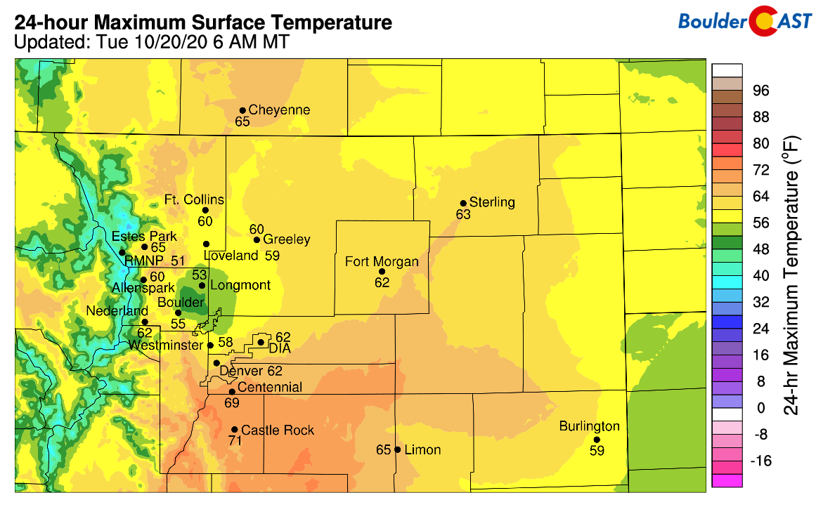
High temperatures from Monday
The good news is that as of 7:00AM, temperatures are already warmer this morning than they were all of yesterday. The bad news is that once again the weather models are leading us astray. Gusty downslope flow took over in some portions of the Metro area around 4:00AM this morning. Winds are gusting at times to near 40 MPH right now. These warm downslope winds were not projected to make it down onto the Plains this morning, but here we are again. The observations from our station early this morning are shown below.
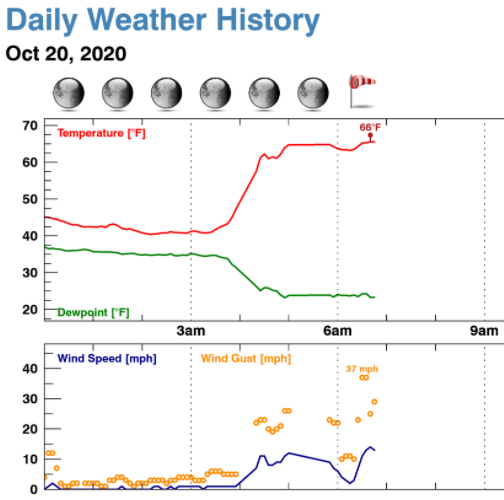
BoulderCAST Station observations from this morning
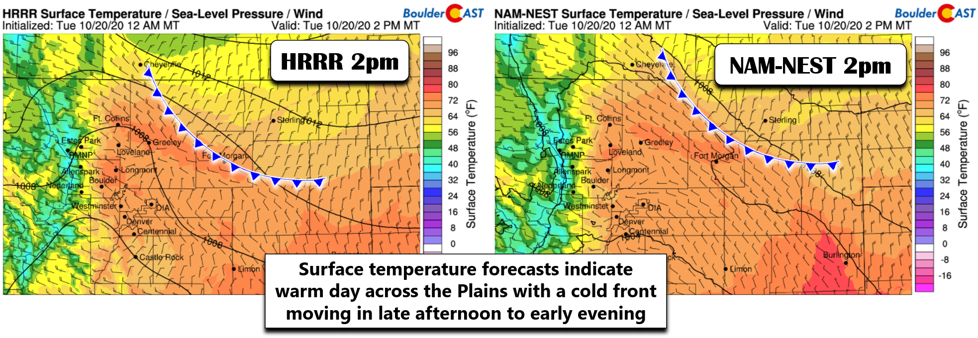
So where does this leave us for today? Well, as long as your area is able to overcome the shallow cool airmass, everyone should get close to 70 degrees with expansive wave clouds but some sunshine at times. Once again, all model support does show this happening, but they did yesterday as well. We’re fairly confident that it will indeed occur today, especially considering the gusty winds reaching parts of the Boulder/Denver area already. Shown below are surface temperature forecasts for the afternoon from two high-resolution weather models. Firstly, note the warm temperatures across the Front Range…upper 60’s to near 70 degrees. Secondly, there is a weak cold front that will be backing into northeast Colorado during this time. It should arrive to the Boulder/Denver area from mid-afternoon into early evening. As you can see below, it is projected to be just northeast of our area at 2:00PM. Behind this front, marginally cooler upslope flow will take hold, but without enough moisture to produce any precipitation. It will lead to chilly overnight temperatures again, but westerly winds will erode the cool airmass quickly again tomorrow leading to highs returning into the 70’s for Wednesday.
Thursday will be a day of transition across our area as a shortwave drops out of western Canada and sweeps across Wyoming. You can see the wave moving in at 500mb in the animation below from the high-resolution NAM model.
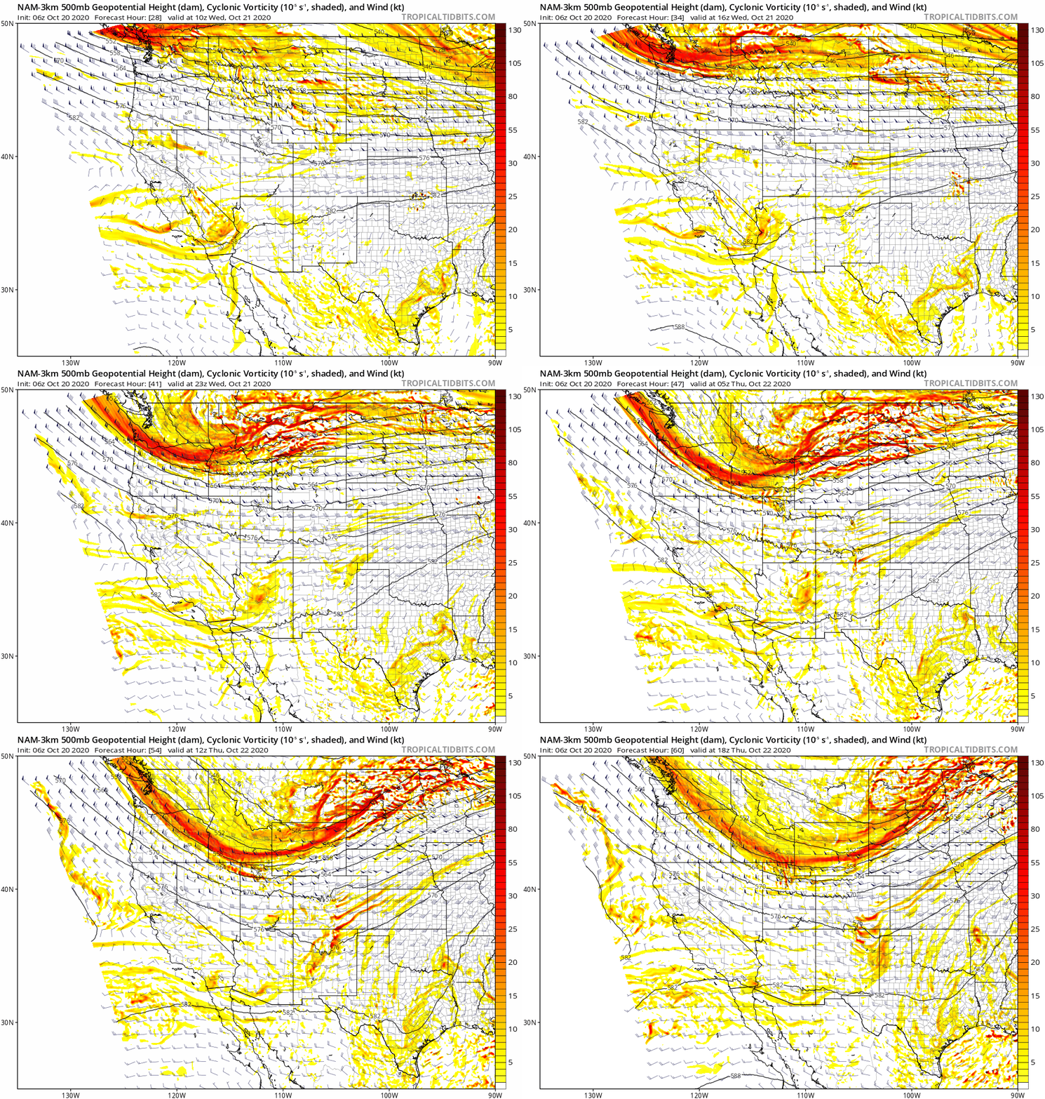
NAM-NEST 500mb vorticity forecast animation from Tuesday night into Thursday afternoon showing the approaching shortwave
The energy from this wave will stay well to our north for the most part with snow accumulations a certainty in Wyoming and Montana, but not in Colorado.
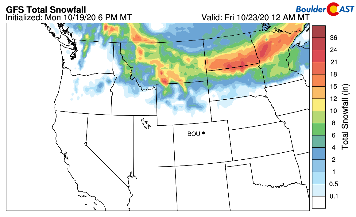
GFS model-derived total snowfall accumulation through Thursday night
The cold front from this system will be stronger and arrive Thursday around mid-day to the Front Range with falling temperatures thereafter. It’s a shallow and cold airmass, with most of us likely dropping below freezing eventually. Additionally, as we discussed in our weekly outlook yesterday, there appears to be a fairly decent chance that low clouds, fog, and potentially freezing drizzle will develop behind this front Thursday night into Friday morning. This could create a light glazing of ice. We’ll should know more about this facet of the forecast tomorrow. Friday probably won’t make it out of the 30’s on the Plains. Brr!
One final note: we are still watching the next storm system set to move into Colorado this weekend. This is the one with subtropical jet access (i.e. moisture will be surging). Models are somewhat consistent at this point and it does appear that some snow will fall in our area. However, we are cautious five days out. The latest Snowfall Probabilities are shown below. Stay tuned on this one!
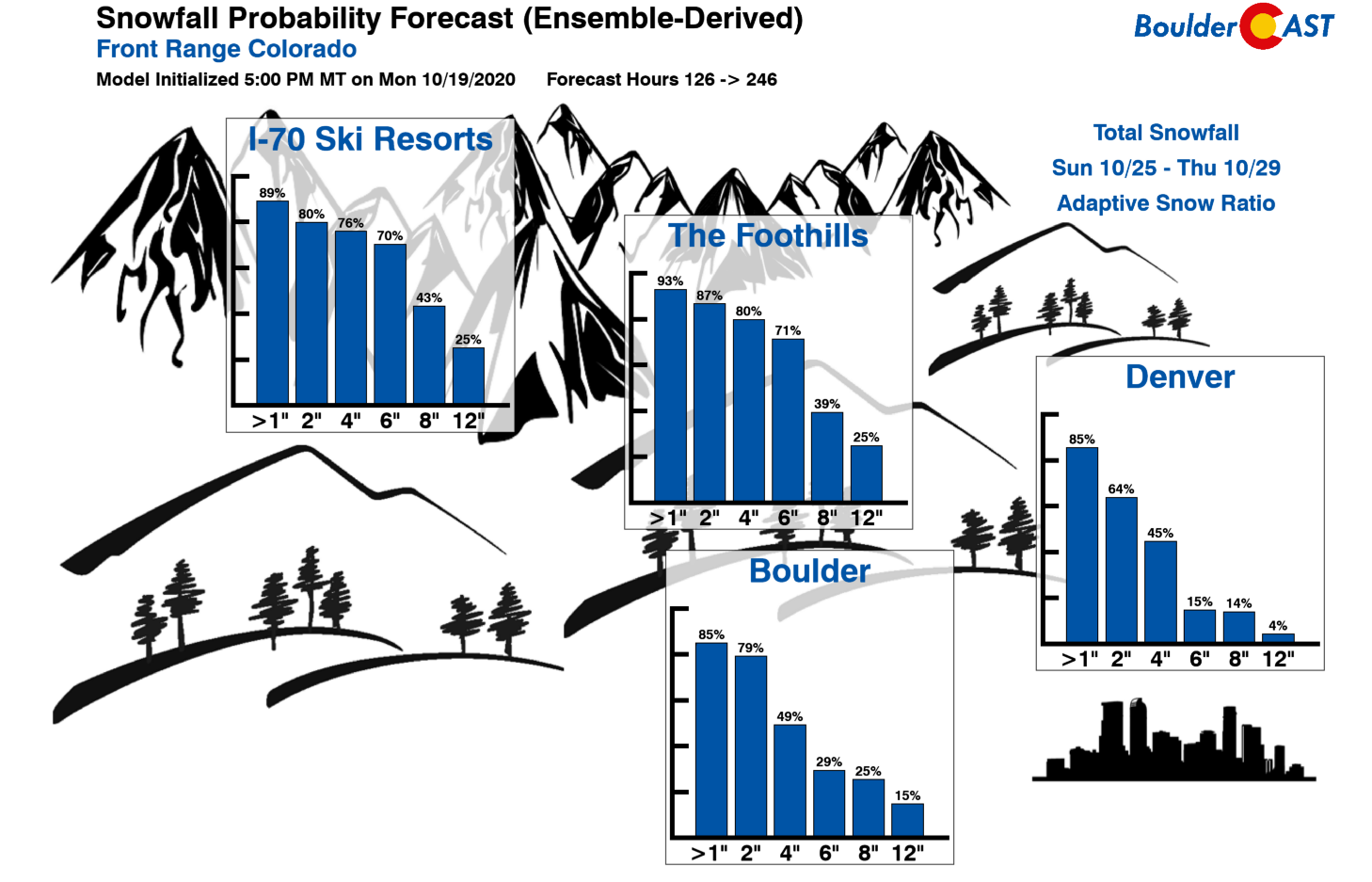
Whew! It’s a surprisingly active week in weather. Between the ongoing fires, downslope winds, multiple cold fronts, freezing drizzle, and the potential snow event for the upcoming weekend, we will be staying busy! Have a good day…
Remember, our daily forecasts are Premium content. Periodically, we open this forecast up to all of our readers. Today is one of those days so please do enjoy!
Help support our team of Front Range weather bloggers by joining BoulderCAST Premium. We talk Boulder and Denver weather every single day. Sign up now to get access to our daily forecast discussions each morning, complete six-day skiing and hiking forecasts powered by machine learning, first-class access to all our Colorado-centric high-resolution weather graphics, bonus storm updates and much more! Or not, we just appreciate your readership!


You must be logged in to post a comment.