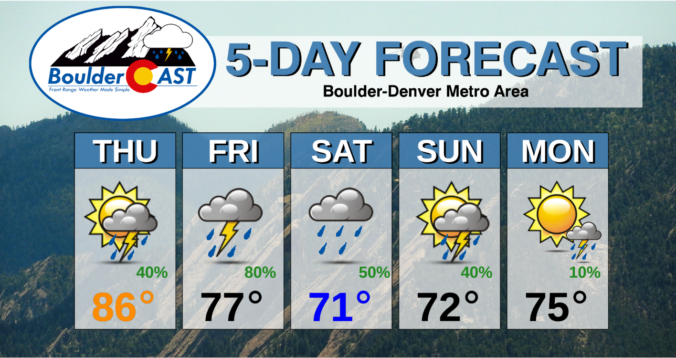
⦁❶⦁ Rain returns to the forecast today with temperatures in the 80’s
⦁❷⦁ An even better chance of thunderstorms on Friday with heavy downpours and some hail possible
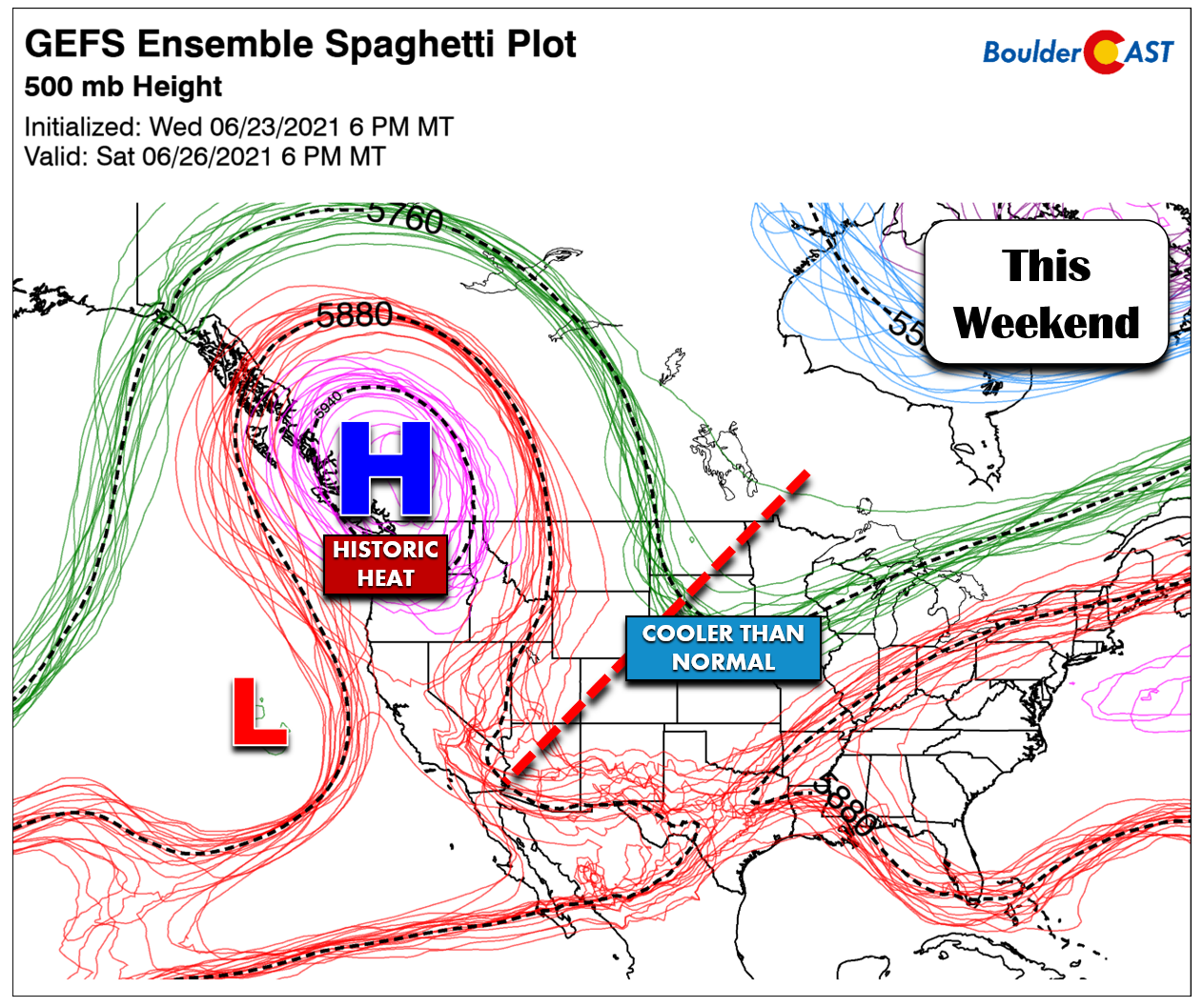
⦁❸⦁ An extremely dangerous heatwave is taking shape in the Pacific Northwest this weekend, but eastern Colorado will remain chilly
⦁❹⦁ Rain chances and below normal temperatures will persist into early next week
Do you want the latest BoulderCAST Daily forecast discussion delivered to your inbox every single morning? If so, join BoulderCAST Premium where we talk Boulder and Denver weather every single day.
Detailed Forecast Discussion:
Good news: the cooler and wetter pattern begins today, which is just in time considering yesterday’s high temperatures were in the mid to upper 90’s across the Front Range. Denver officially soared to 97°F, while Boulder reported 96°F. While toasty, these were a far cry from the daily record values for June 23rd. Both Denver and Boulder needed to beat 104°F to set new records yesterday, which is one of the highest daily records for the entire summer in both cities.
GOES-East water vapor imagery this morning shows a plume of moisture surging across Colorado aloft from the southwest. This is the plume we focused on yesterday. This moisture is producing a lot of cloud cover across the Metro area this morning and even a few raindrops overnight in the higher terrain and east of Denver. Downslope flow and a dry surface layer has largely kept the immediate Boulder-Denver area entirely rain-free so far. This will change later today, however!
All of the ingredients are coming together for a stormy afternoon across the area! We’ve already discussed the moisture influx. There are also two shortwave troughs approaching Colorado from the northwest that will become one in the next few days. For today, however, we’ll cash in on lift from the first trough and an associated jet streak to help fire afternoon storms. We also note some upslope flow at the surface, a weak front of sorts, that will add further fuel to the fire.
The moderately strong southwest flow aloft is allowing for good shear across eastern Colorado today as well, lending to the potential for severe weather across eastern Colorado. The only issue is instability (CAPE) which is lacking across the Front Range. Storms across the Denver/Boulder area will be run-of-the-mill but offer the potential for bursts of moderate rain. As the thunderstorms progress eastward into a more favorable environment, some could become severe. The Storm Prediction Center has locations east of the Front Range at risk for hail and damaging winds later today.

Severe weather outlook from the Storm Prediction Center for today. The risk for hail and strong winds is east of the Denver area
Storms will be common today after noon until the late evening hours. Shown below are two high-resolution model radar forecasts for 4PM today. Overall there is good agreement for scattered storms across the area. We have the chance of storms at about 40% today. Spotty rain showers and isolated storms could linger into the overnight hours as well, mainly north of Boulder to the Wyoming border.

Simulated radar forecast for 4PM today from the HRRR model (left) and the NAM-NEST model (right). Scattered storms will be around our area.
High temperatures drop back into the 80’s today. Do keep an eye to the sky for developing thunderstorms!
The setup tomorrow will be very similar, but will be aided by a stronger cold front and associated upslope. As we have discussed all week long, we’re expecting widespread showers and storms to commence during the afternoon and evening hours on Friday with temperatures only in the 70’s. What a great way to end the week; this is definitely the pattern we need! The severe threat will shift slightly westward to include the Denver Metro as well, with 1″ hail the primary threat. Given the forcing and moisture in play, heavy rainfall rates will accompany the storms on Friday leading to potential flooding concerns for the burn scars in the Mountains and Foothills.

Severe weather outlook from the Storm Prediction Center for Friday. Isolated severe storms may be possible in the Denver area
If you haven’t heard, an historic heatwave is about to unfold across the Pacific Northwest as an extremely strong high pressure center gets pinched off north of Seattle (see below). This pattern will support the obliteration of all-time city and state record high temperatures from northern California into Oregon and Washington (and much of southwest Canada as well!). Seriously…this is very dangerous situation for locations that are not heat-prepared, even as much as Denver is.
There is a silver-lining to this extreme heatwave. Due to the wavy nature of the atmosphere, when there is a scorching heatwave in the Pacific Northwest (or the East Coast), our weather tends to be cooler than normal in eastern Colorado and that will be the case in the coming days. The chilly and rainy pattern will continue through the weekend ahead into early next week. There is some indication that much next week could remain near or below normal as well, but we’ll reserve our thoughts on that for now.

Daily temperature anomalies through the weekend into early next week. While the PNW sizzles, the Front Range will be chilly.
Here’s a look at the next five days in the Boulder-Denver area. Your eyes are not deceiving you! Rain is in the pipeline each and every day with temperatures remaining well below normal. This stretch will likely be enough to knock June 2021 out of top ten contention for the hottest and driest Junes in the historical record. Oh, and with our flow primarily coming from the north and northwest out of Canada in the extended, the smoke situation will improve dramatically after about midday Friday!
Remember, our daily forecasts are Premium content. Periodically, we open this forecast up to all of our readers. Today is one of those days!
Help support our team of Front Range weather bloggers by joining BoulderCAST Premium. We talk Boulder and Denver weather every single day. Sign up now to get access to our daily forecast discussions each morning, complete six-day skiing and hiking forecasts powered by machine learning, first-class access to all our Colorado-centric high-resolution weather graphics, bonus storm updates and much more! Or not, we just appreciate your readership!


You must be logged in to post a comment.