Author: Ben Castellani (Page 39 of 303)
Ben grew up in southwestern Pennsylvania and holds both a bachelor's and a master's degree in Meteorology, the latter being from CU Boulder. His hometown received nearly three feet of snow from the Storm of the Century back in March of 1993, sparking his initial interest in impactful weather. Ben currently works on remote sensing and data analysis software at NV5 Geospatial Software in Boulder.
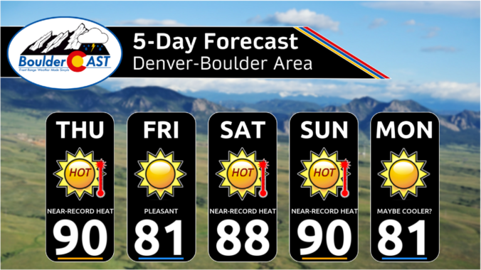
The Front Range experienced its first significant rainfall in five months, with some areas receiving up to an inch of rain over the weekend. The start of the work week will be relatively cool. However, a strong ridge pattern known as an omega block will bring warm and dry conditions from Wednesday onwards, with temperatures rising into the 80s and potentially reaching record highs by Thursday. While there is no hope for any snow in our forecast yet, our 10th Annual First Snow Contest will open to entries later this week. Read on for all the details.
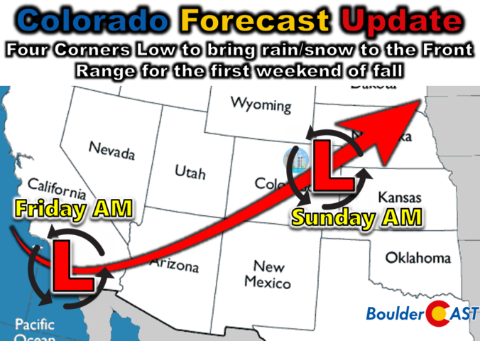
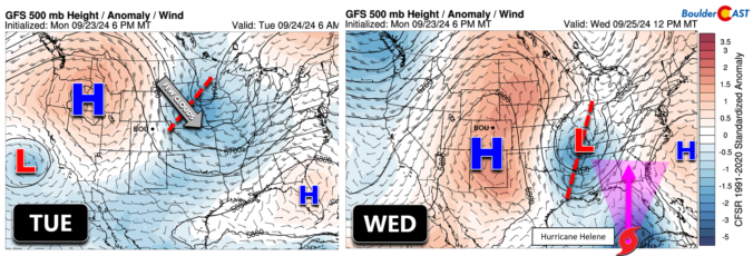
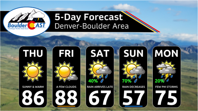
This weekend will surely feel a lot different than recent ones as the first autumn storm system of the year arrives into Colorado — conveniently aligning with the official first day of autumn on Sunday. While a fair amount of uncertainty remains in potential precipitation totals for the Front Range, everyone should see an extended period of light to moderate rainfall from late Saturday afternoon into Sunday morning. Fortunately it is still too warm for frozen precipitation across the lower elevations, but snow will fall in the Mountains accumulating up to several inches. Here’s our latest thoughts on what has turned out to be a tricky storm to forecast!

Live View of Boulder

Current Conditions

Live Radar

Recent Premium Posts

BoulderCAST Daily – Sat 05/30/26 | A stray shower today as most activity resides well east of Denver
🌦️ Spotty showers today, mainly well east of the Denver Metro area, where …
BoulderCAST Daily – Fri 05/29/26 | A Marginal Risk of Severe Isolated Storms
🌦️ Spotty showers this afternoon, mainly noon and 4 PM, with highs in …
This Weekend in Colorado Weather: Unsettled but Manageable as Low-End Storm Chances Hang Over the Front Range
🌎 Omega block holds through early next week, but slowly shifts toward the …
3-Day Forecast

Trending Content

© 2026 Front Range Weather, LLC