Author: Ben Castellani (Page 289 of 302)

Ben grew up in southwestern Pennsylvania and holds both a bachelor's and a master's degree in Meteorology, the latter being from CU Boulder. His hometown received nearly three feet of snow from the Storm of the Century back in March of 1993, sparking his initial interest in impactful weather. Ben currently works on remote sensing and data analysis software at NV5 Geospatial Software in Boulder.

El Niño update and the outlook for the second half of winter

sstaanim

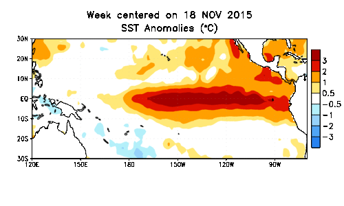
On paper, the 2015-16 super El Niño became everything that it was forecast to be, with water temperatures across the equatorial Pacific Ocean warming to near-record levels. However, the location and extent of the warming, and the global impacts, have been anything but typical. We discuss how well our last El Niño forecast verified and the outlook for the remainder of our winter season. What can Boulder expect in the way of precipitation, snowfall, and temperatures heading forward? Read on to find out.

Continue reading

The week ahead: February 8-12, 2016

Congratulations to the World Champion Denver Broncos! Weather was definitely not a factor during the game, which is how the NFL’s championship should be played! Let the better team win without any of Mother Nature’s shenanigans.

On that note, that beautiful California weather will spread east to include Colorado this week. We really couldn’t have hand-picked two consecutive, polar-opposite weeks of weather if we tried. Just seven days ago, we were in winter weather forecast mode, with more than a foot of snow knocking on the door. This week, our discussion focuses on a significant warming pattern as a ridge builds across the West.  Read on to find out if and when we will have a chance for record heat.

Continue reading

Mid-winter Colorado snowfall briefing

Are you beginning to anticipate those hot, sunny, and at times, stormy summer afternoons? You’re definitely not alone. Winter in Colorado can be long, with snow possible (and dare I say, common) nine months out of the year, even on the Plains. Following our biggest single-storm snow event in nearly three years, we check in on our snow totals and mountain snowpack thus far for the 2015-16 winter season.

Continue reading

Why was this week’s snowstorm so easy to predict?

Boulder_Flatirons_snow

Two weekends in a row, forecast models get to pat themselves on the back for accurately predicting major snowstorms more than seven days in advance. While this is a great showcase for the advancement of modern numerical weather prediction, it shouldn’t be considered a common occurrence. Model uncertainty, especially that far in advance, is still very large. After all, weather is the poster child for chaos theory!

As this week’s storm slid across the North Pacific Ocean on it’s way to Colorado, we were hesitant to inject any definitive snowfall amounts into our forecasts. Remarkably, looking back, if we had to issue a forecast a week ahead of time, it wouldn’t have looked all that different from our snowfall map the day before. We explain why this storm was a relatively easy forecast, and issue a few words of caution as we head through the second half of our winter season.

Continue reading

Episode #23: Snowstorm Predictions

What factors are impacting our forecast for the upcoming snowstorm? What are the potential implications if we officially adopt the naming of winter storms? Where did Joseph get the mysterious box of cookies he brought to the podcast? Listen to find out!

*NOTE* For those interested in discussion related specifically to the impending snowstorm, that begins at the 1 hour, 10 minute mark of the audio

Continue reading

« Older posts Newer posts »