



The main story for the week ahead will be the roller-coaster ride of temperatures! They will soar to near 80 degrees by midweek, but then tumble to bring the chance of snow to the region by Thursday. Read on for our complete outlook of the upcoming week.
Author: Ben Castellani (Page 271 of 358)
Ben grew up in southwestern Pennsylvania and holds both a bachelor's and a master's degree in Meteorology, the latter being from CU Boulder. His hometown received nearly three feet of snow from the Storm of the Century back in March of 1993, sparking his initial interest in impactful weather. Ben currently works on remote sensing and data analysis software at NV5 Geospatial Software in Boulder.
One reason for the recent stretch of quiet and warm weather in Colorado is that the position of jet stream is FAR to our north in Canada. Weather systems tend to form near the jet stream….along the baroclinic boundary between warm and cold air masses. Without the jet, our pattern has been quiet this week and this will continue through Friday evening.

250 mb wind map for this afternoon showing the position of the jet stream (lime green).
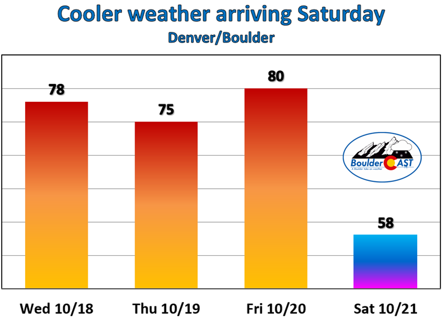
For today, expect mid-level clouds to dominate the sky in the morning as a swath of elevated moisture interacts with the terrain. However, drier air aloft moves in by lunch which will allow for sunshine this afternoon and evening. High temperatures will be in the upper 70’s today!
After 70’s tomorrow and possibly low 80’s on Friday, a dry cold front sweeps through Friday night. Temperatures will tumble about 20 degrees for Saturday, but at least that sun won’t stop shining…
Remember, these daily forecasts are Premium content. Periodically, we open this forecast up to all of our readers. Today is one of those days!
Sign up today to get the best BoulderCAST experience, including these daily forecasts every morning, complete 6-day skiing and hiking forecasts, chat room and forum access, early viewing of select content and much more!
As a special pre-winter promotion, use the promo code SNOW to receive 30% off our annual subscription. This is our last offer of 2017 and it expires October 31st. LEARN MORE

.

We hope you enjoyed the Columbus Day holiday! In this special weekly outlook, we provide a brief recap of yesterday’s snowstorm, announce the winners of our 2017 First Snow Contest, and detail the warm and sunny weather about to make a rebellious stand across Colorado.
Live Radar

Trending Content


Recent Premium Posts

BoulderCAST Daily – Sat 11/14/26 | A Pair of Foggy Mornings With Little Rain
🌫️ A Pair of Foggy Mornings — Moisture banked up along the Foothills …
BoulderCAST Daily – Fri 11/13/26 | Quiet Today But Turning Unsettled Tomorrow
☀️ Quiet Today — Sunshine and low to middle 60s across the Front …
This Weekend in Colorado Weather: The Quiet Pattern Ends as Storm Activity Picks Up Across the West
After weeks of sunshine, mild afternoons, and storm systems repeatedly missing Colorado to …
© 2026 Front Range Weather, LLC
You must be logged in to post a comment.