


Author: Ben Castellani (Page 261 of 358)
Ben grew up in southwestern Pennsylvania and holds both a bachelor's and a master's degree in Meteorology, the latter being from CU Boulder. His hometown received nearly three feet of snow from the Storm of the Century back in March of 1993, sparking his initial interest in impactful weather. Ben currently works on remote sensing and data analysis software at NV5 Geospatial Software in Boulder.
Premium Storm Update (Mon Feb 5 at 1:30 PM) Ensembles are out to lunch for tonight’s snow! We provide a brief storm update along with a discussion on why the ensemble model runs are worthless for this particular wintry event. READ NOW
—
This week will see rain changing to snow Monday evening. We have included our official snowfall forecast map. We’ll then see a significant warming trend through the rest of the week as a lee trough develops, with the potential for more snowfall during the upcoming weekend.
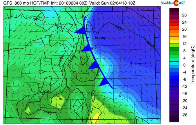
Yet another shallow Arctic front has backed into the Metro area this morning, with light snow and freezing drizzle now falling across the region. We detail the weather for the next 48 hours, including the chance of more wintry weather Monday night.
*Contest entries are now closed*
What is the outlook for snowfall in the next three months? You tell us! We provide a brief overview of the climatology, long-range model forecasts, and La Niña for the next three calendar months. We then ask for YOUR long-range forecast for snowfall in Boulder. Prizes include Amazon gift cards, BoulderCAST T-Shirts, and Premium subscriptions. Enter now!
February begins on a cold and wintry note! Read our complete forecast.
Live Radar

Trending Content


Recent Premium Posts

BoulderCAST Daily – Sat 11/14/26 | A Pair of Foggy Mornings With Little Rain
🌫️ A Pair of Foggy Mornings — Moisture banked up along the Foothills …
BoulderCAST Daily – Fri 11/13/26 | Quiet Today But Turning Unsettled Tomorrow
☀️ Quiet Today — Sunshine and low to middle 60s across the Front …
This Weekend in Colorado Weather: The Quiet Pattern Ends as Storm Activity Picks Up Across the West
After weeks of sunshine, mild afternoons, and storm systems repeatedly missing Colorado to …
© 2026 Front Range Weather, LLC