Author: Ben Castellani (Page 25 of 294)
Ben grew up in southwestern Pennsylvania and holds both a bachelor's and a master's degree in Meteorology, the latter being from CU Boulder. His hometown received nearly three feet of snow from the Storm of the Century back in March of 1993, sparking his initial interest in impactful weather. Ben currently works on remote sensing and data analysis software at NV5 Geospatial Software in Boulder.
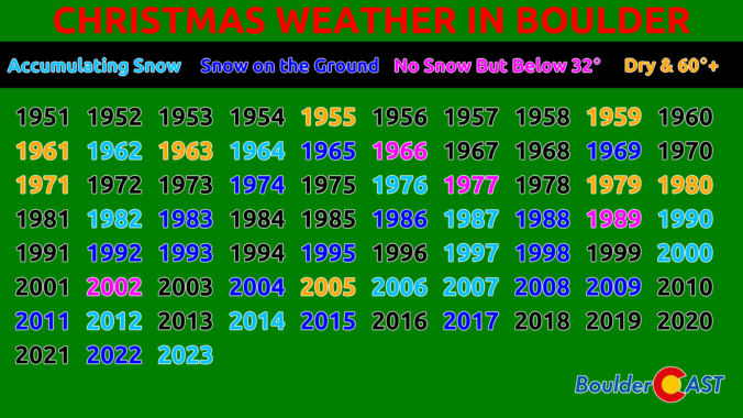
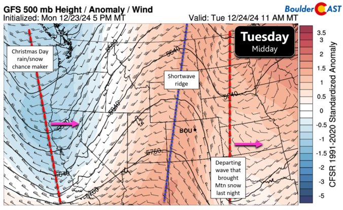
After days and days of warm and dry weather, things in the Front Range are taking an interesting turn right in time for Christmas. A trough of low pressure is moving into the Four Corners area right now with a mix of clouds and sunshine out ahead of it. Later in the day, a cold front will move through from the northeast leading to scattered showers spawning across the western Metro area. Mostly rain is expected for the lower elevations which will be largely too warm, but Foothills communities could pick up a few slushy inches this evening to nab a white Christmas after all! We discuss a bit of Christmas climatology for Boulder, the weather setup at hand today, the latest timing of the rain/snow showers, and just how much accumulation may fall this evening and where.
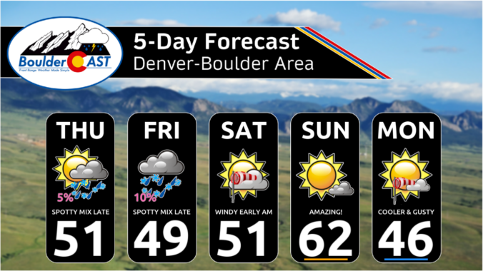
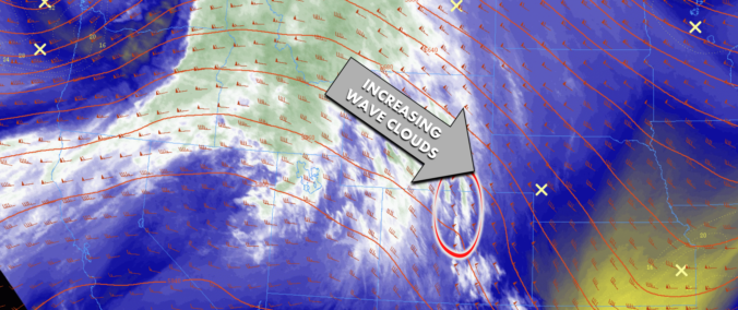
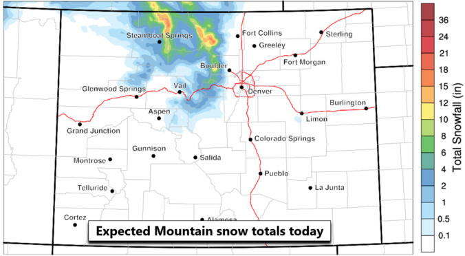
This week’s weather in the Front Range will see a shift from the recent unseasonably warm temperatures to cooler conditions, with periodic light snow expected in the Mountains throughout the week. While a white Christmas is unlikely for the Denver Metro area, there will be a slight chance of rain or snow showers Wednesday evening and night. The late-week period will remain active with several disturbances bringing more light snow to the Mountains, but the lower elevations around Boulder and Denver will stay mostly dry with mild temperatures. We also look ahead to next week when we’ll likely see a longer-term transition to much colder and snowier weather for the New Year.
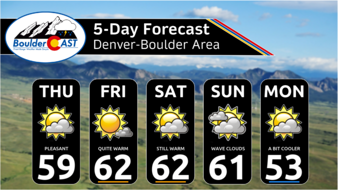
As we rapidly approach the holiday season, the Front Range continues to experience unseasonably warm and dry conditions. This past weekend brought beautiful weather with temperatures warming into the 50s, accompanied by strong downslope winds at times. Looking ahead, the forecast remains mostly quiet with high pressure dominating the central Rockies, including Colorado. While a few bouts of wind are expected this week, precipitation will be nearly non-existent over the next seven to ten days, making a white Christmas highly unlikely for the Denver-Boulder area.

Live View of Boulder

Current Conditions

Live Radar

Recent Premium Posts

BoulderCAST Daily – Sun 01/11/26 | A mild Sunday with readings reaching the 50s
🌤️ Mild & Melty Sunday: Light winds and patchy clouds, with lingering snowpack …
BoulderCAST Daily – Sat 01/10/26| Widespread sunshine and moderating temperatures this weekend as our recent snow melts off
🌤️ Calm Saturday: Winter storm systems have departed the state, leaving behind a …
BoulderCAST Daily – Fri 01/09/26| Snow ends quickly this morning with a quieter weekend in store
❄️ Overnight snow bands: A second push of upslope after midnight sparked narrow …
3-Day Forecast

Trending Content

© 2026 Front Range Weather, LLC