


Author: Ben Castellani (Page 196 of 358)
Ben grew up in southwestern Pennsylvania and holds both a bachelor's and a master's degree in Meteorology, the latter being from CU Boulder. His hometown received nearly three feet of snow from the Storm of the Century back in March of 1993, sparking his initial interest in impactful weather. Ben currently works on remote sensing and data analysis software at NV5 Geospatial Software in Boulder.
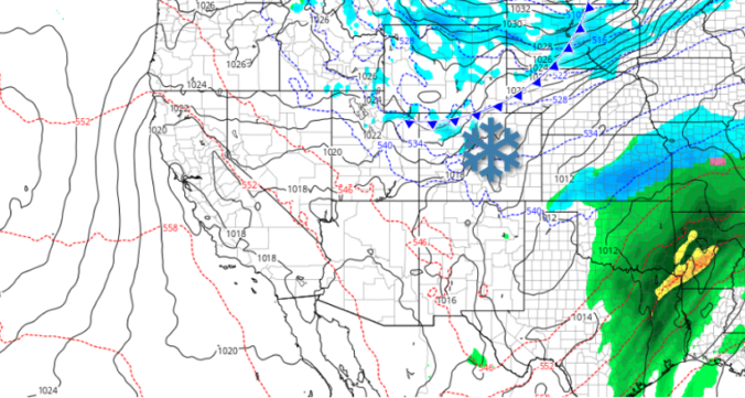
Models finally came into a snowy agreement last evening and unfortunately this means we have another round of snow to deal with Wednesday afternoon and evening, one which may turn out quite similar to what transpired on Monday. Read on for our full forecast, including when the snow will start and how much to expect in your area.
Pockets of jet-forced snow began to fall Thursday evening and continued intermittently through Friday afternoon across the Metro area. Bands of moderate to heavy snowfall were most prevalent near and south of Interstate 70 in the Denver Metro area and in the Foothills of Jefferson County where 8-16″ of snow was reported.
Shown below is the BoulderCAST snowfall forecast map issued Sunday (February 2nd) during the afternoon with actual storm totals overlaid in boxes. Green boxes indicate that our forecast verified to within one inch of the observed snowfall. Red did not.

| Seasonal Snow Totals (Updated Feb 5 2020) |
|---|
| Boulder | Denver |
|---|---|
| 73.0" | 32.7" |
Live Radar

Trending Content


Recent Premium Posts

This Weekend in Colorado Weather: The Quiet Pattern Ends as Storm Activity Picks Up Across the West
After weeks of sunshine, mild afternoons, and storm systems repeatedly missing Colorado to …
BoulderCAST Daily – Wed 11/11/26 | Mild Days Ahead, But There Are Signs of a More Active November Soon
☀️ Warm & Quiet — Sunshine dominates through Thursday with highs rising from …
BoulderCAST Daily – Tue 11/10/26 | Clouds Increase Today, But Colorado’s Dry Pattern Rolls On
🌤️ A Few More Clouds Today – Mountain wave clouds are developing along …
© 2026 Front Range Weather, LLC
You must be logged in to post a comment.