Author: Ben Castellani (Page 1 of 295)
Ben grew up in southwestern Pennsylvania and holds both a bachelor's and a master's degree in Meteorology, the latter being from CU Boulder. His hometown received nearly three feet of snow from the Storm of the Century back in March of 1993, sparking his initial interest in impactful weather. Ben currently works on remote sensing and data analysis software at NV5 Geospatial Software in Boulder.
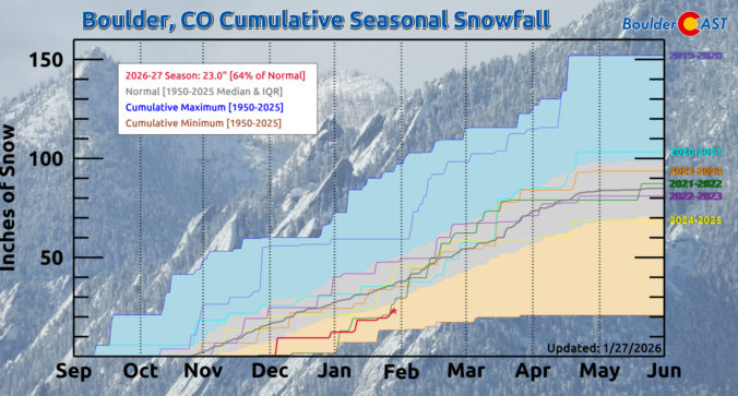
fleeting brush with winter may have swept across the Front Range this past weekend, but the atmosphere isn’t planning to stick with the theme for long. That sharp Arctic plunge—while refreshing for snow lovers—was more of a brief interruption than a true turning point. A closer look at the pattern ahead shows Colorado snapping right back into its now‑familiar routine of warm afternoons, bone‑dry air, and a statewide snowpack sitting at record‑low levels. Winter may have knocked on the door, but it certainly isn’t moving in.
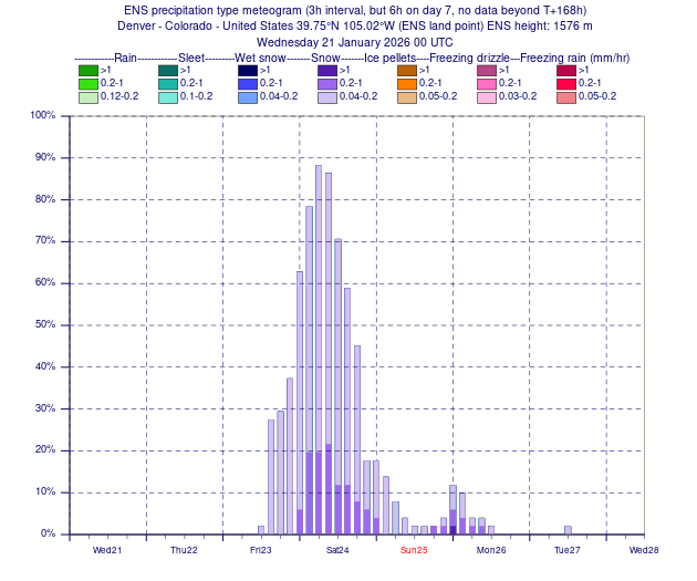
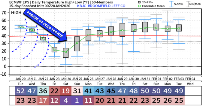
A stubborn weather pattern is settling in this week, and Colorado finds itself right in the middle of the action—or the lack of it. While the coasts deal with weather extremes, the Front Range gets a quieter blend of mild spells, a couple of cold fronts, and just enough uncertainty to keep things interesting. Read on for our full outlook of the next seven days to see if this translates into meaningful moisture or just more dry January days.

Live View of Boulder

Current Conditions

Live Radar

Recent Premium Posts

BoulderCAST Daily – Tue 01/27/26 | Early morning clouds will give way to a sunny Tuesday
🌤️ Clouds Clearing Fast — Early morning mid‑level clouds from northwest flow fade …
BoulderCAST Daily – Sun 01/25/26 | Light snow develops later today into this evening
❄️ Light snow this afternoon and tonight: A fast-moving clipper type system brings …
BoulderCAST Daily – Sat 01/24/26 | Bitter Cold This Weekend With Light Snow Again Sunday
🥶 Arctic blast is here: Arctic Air lingers through the weekend with teens …
3-Day Forecast

Trending Content

© 2026 Front Range Weather, LLC