Author: Andy (Page 73 of 217)
Born and raised in St. Louis, Andrew obtained a Ph.D. in Atmospheric Science from the University of Colorado in 2015. From 2015 to 2020, he worked remotely in Boulder as an atmospheric scientist with NOAA's Atlantic Oceanographic and Meteorological Laboratory in Miami. Andy is now a full-time meteorologist.
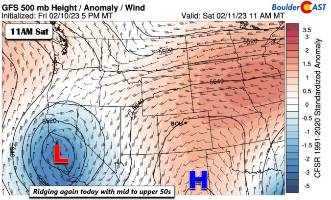
There will be two chances of snow to contend with this week, but neither will be much of a concern for us. A few flurries or snow showers are possible on Monday as a weak wave passes through. Later on, a stronger trough approaches with a cold front late Wednesday into Thursday, where colder temperatures in the 30s and gusty winds will be the primary impacts. Current indications of this mid-week system favor the better chance of snow in the High Country, but there could be a brief burst of snowflakes across the lower elevations as well. Read on for more details.


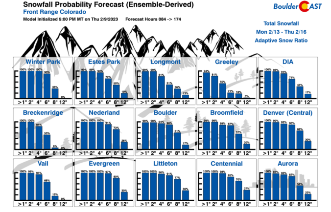
⦁❶⦁ Freezing drizzle turns to snow this afternoon/evening bringing a trace to 2 inches to the Front Range by sunrise Sunday; hefty snow totals for the High Country through the weekend
⦁❷⦁ Highs near or below freezing today falling into the single digits tonight with an Arctic cold front
⦁❸⦁ Another chance of light snow Sunday night into Monday but less certain, amounts expected to be very light

Live View of Boulder

Current Conditions

Live Radar

Recent Premium Posts

BoulderCAST Daily – Sun 05/31/26 | Dry and warm today but rain chances increase this week
🌦️ Overall dry and warm Sunday, though cannot rule out a very widely …
BoulderCAST Daily – Sat 05/30/26 | A stray shower today as most activity resides well east of Denver
🌦️ Spotty showers today, mainly well east of the Denver Metro area, where …
BoulderCAST Daily – Fri 05/29/26 | A Marginal Risk of Severe Isolated Storms
🌦️ Spotty showers this afternoon, mainly noon and 4 PM, with highs in …
3-Day Forecast

Trending Content

© 2026 Front Range Weather, LLC