
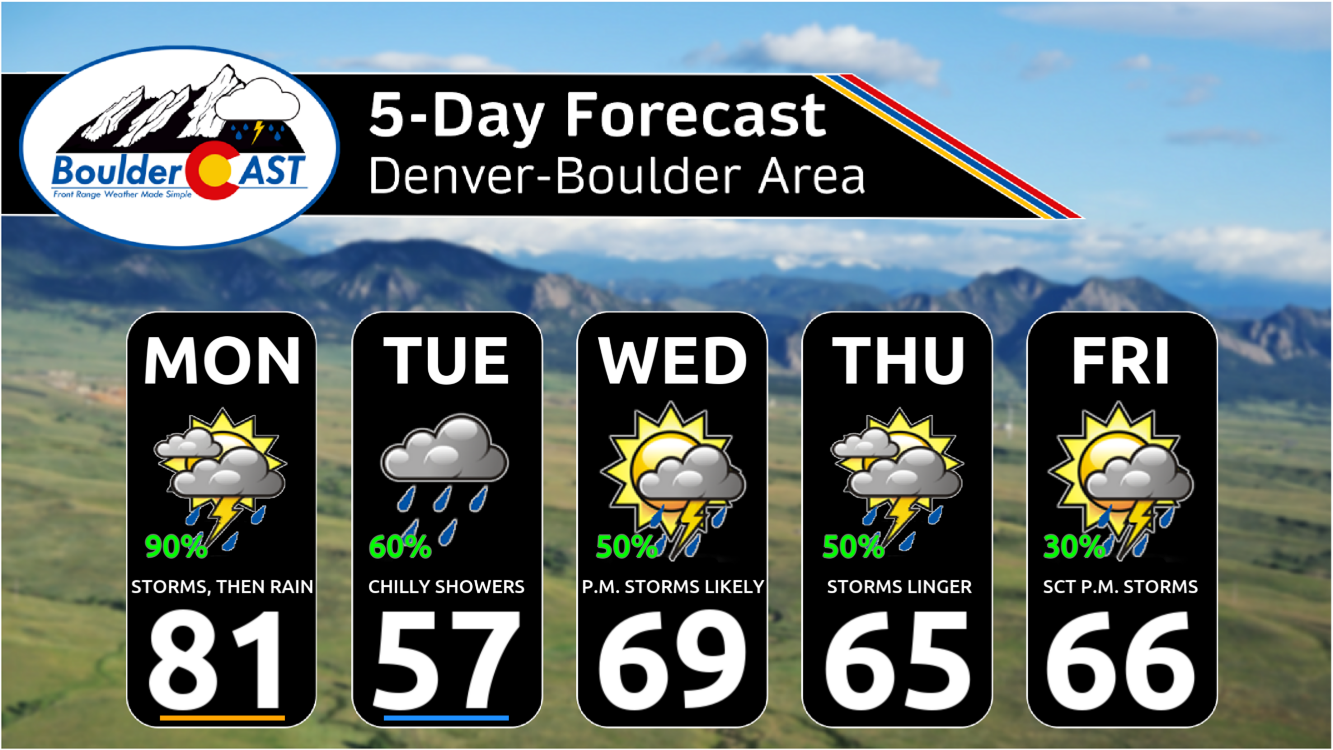
As we step into the first full week of June, get ready for more cool and wet weather in the Front Range! A promising rain event kicks off the week Monday afternoon through midday Tuesday, with a cold front bringing much cooler temperatures and widespread showers and storms. Rain chances will linger through much of the week ahead, though uncertainty remains on exactly how things will unfold from midweek onwards. Expect highs to drop from the 80s Monday into the 50s Tuesday, and continue to run below average the rest of the week. If you were hoping for a dry stretch for early June, you might need to adjust your plans—keep those umbrellas handy!
This week’s highlights include:
- Wet Start to June: Rain will be widespread from Monday afternoon through midday Tuesday, with lingering shower chances throughout the week.
- Cold Front Moves In: A front Monday night will bring steady rain and cooler temperatures, with highs dropping from the 80s Monday to the 50s Tuesday.
- Early Week Rainfall Totals: Most areas will see 0.5” to 1” of rain, with isolated spots reaching 1.5+ inches.
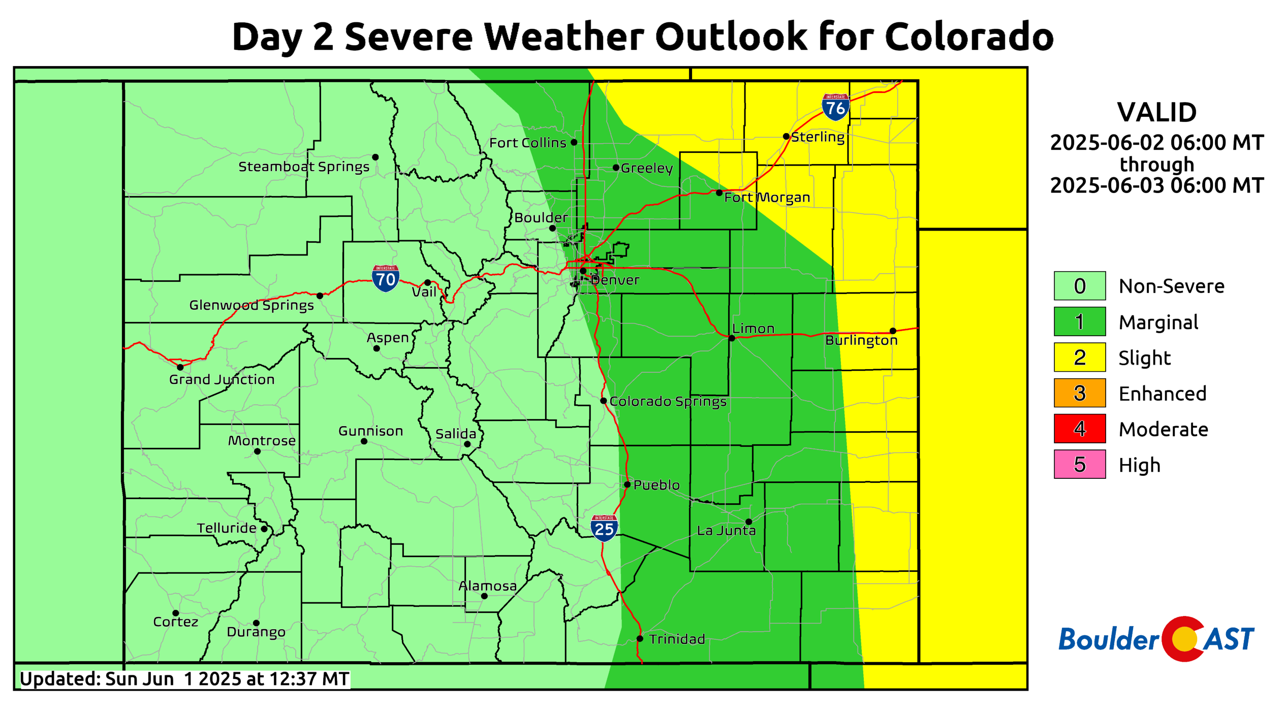
- Severe Risk Monday: There is a risk of severe storms Monday with local damaging winds and hail the primary threats
- Midweek Uncertainty: Shower chances continue Wednesday through Friday, but details on a California-based system’s impact are still unclear; temperatures will stay below average in the mid-60s to low-70s.
DISCLAIMER: This weekly outlook forecast is created Monday morning and covers the entire upcoming week. Accuracy will decrease as the week progresses as this post is NOT updated. To receive daily updated forecasts from our team, among many other perks, subscribe to BoulderCAST Premium.

Go Premium, get all the perks.
Daily Forecast Updates
Get our daily forecast discussion every morning delivered to your inbox.
All Our Model Data
Access to all our Colorado-centric high-resolution weather model graphics. Seriously — every one!
Ski & Hiking Forecasts
6-day forecasts for all the Colorado ski resorts, plus more than 120 hiking trails, including every 14er.
Smoke Forecasts
Wildfire smoke concentration predictions up to 72 hours into the future.
Exclusive Content
Weekend outlooks every Thursday, bonus storm updates, historical data and much more!
No Advertisements
Enjoy ad-free viewing on the entire site.
A Wet Start to June: Rain and Cool Temperatures Ahead
TThe first full week of June is kicking off with wet weather, and rain chances will stick around for much of the week. While some uncertainty remains for midweek and beyond, the main period of steady rain will come Monday afternoon into midday Tuesday.
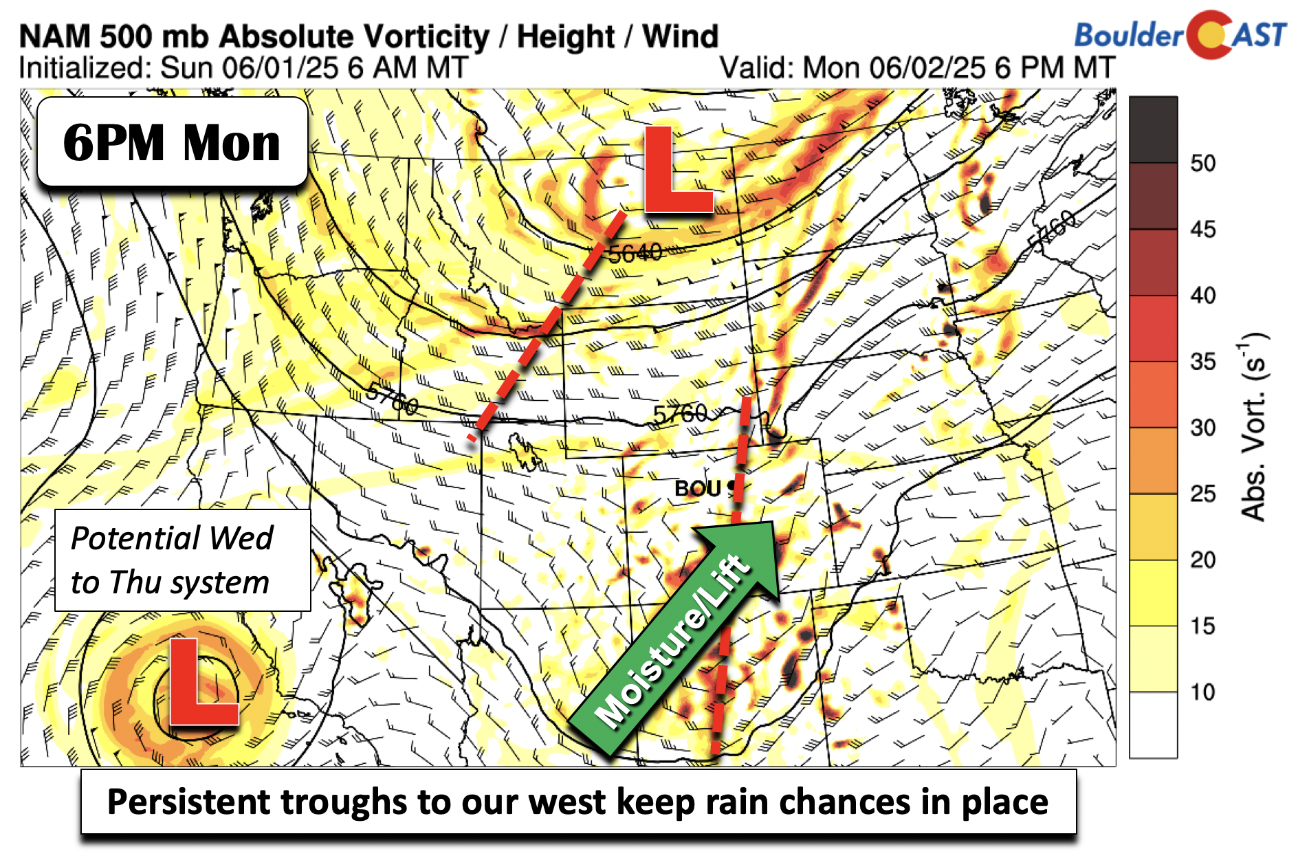
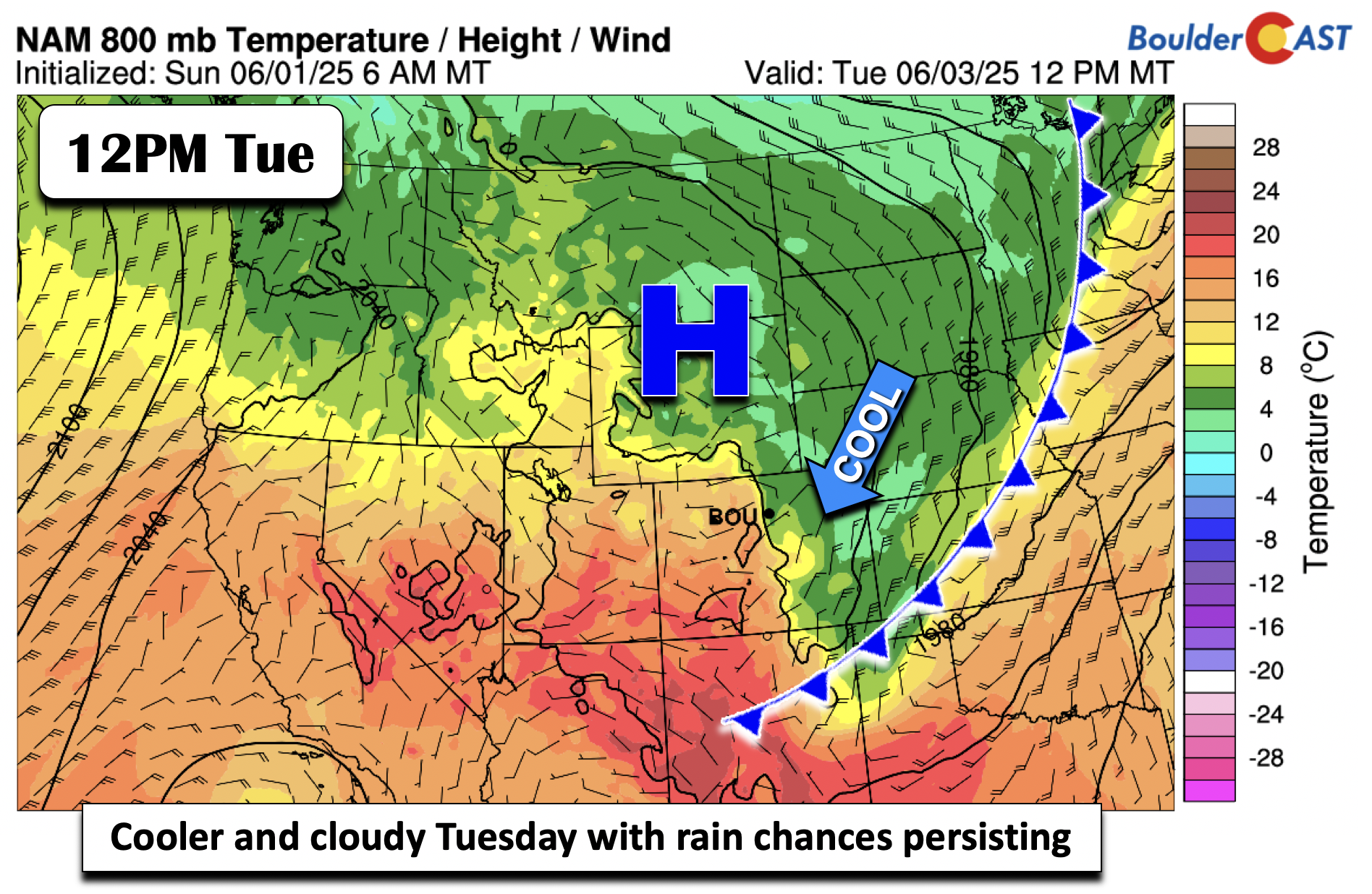
Aloft, a closed-low will become an open wave as it gets pulled northward into Colorado Monday evening, thanks to a trough coming in across Montana. Deeper moisture will get advected into the region landing well above seasonal averages with precipitable water values peaking over 1″ in the Denver area late Monday. We’ll also discuss a front that will aid these rain chances overnight. Before that, we also wanted to mention another system that is presently off the California coast. This will be our next weather system, impacting the area sometime Wednesday or early Thursday.
Our Monday will actually be the only day this week where highs will be above normal in the low to middle 80s. The rest of the week will see cooler than normal conditions.
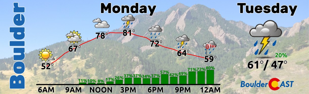
We expect scattered showers and storms to develop Monday afternoon and evening across the area. Initial storm activity will have the chance to reach severe limits, though the greatest severe risk is over far eastern Colorado, Kansas and Nebraska, where a low-end tornado threat will be possible. Over us, locally damaging winds and hail up to half-dollar-sized are the primary threats, mainly for areas along and east of Boulder.
A cold front will sag south Monday night and settle into New Mexico and the Texas Panhandle by Tuesday afternoon. As the front moves southward, increasing frontogenetical forcing along the boundary will combine with the mid-level moisture and energy to fuel continued widespread showers overnight into early Tuesday morning. Temperatures by sunrise on Tuesday will be chilly in the upper 40s, while afternoon readings won’t budge that much with low clouds in-place and rain chances persisting — highs in the mid to upper 50s.
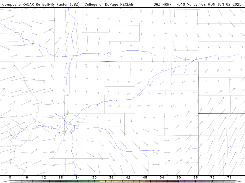
The simulated radar animation below shows how the event may unfold Monday afternoon into early Tuesday, with scattered storms initially across the entire area, eventually transitioning to widespread, largely stratiform rain Monday night as the cold frontal forcing and reinforcing upslope flow take hold.
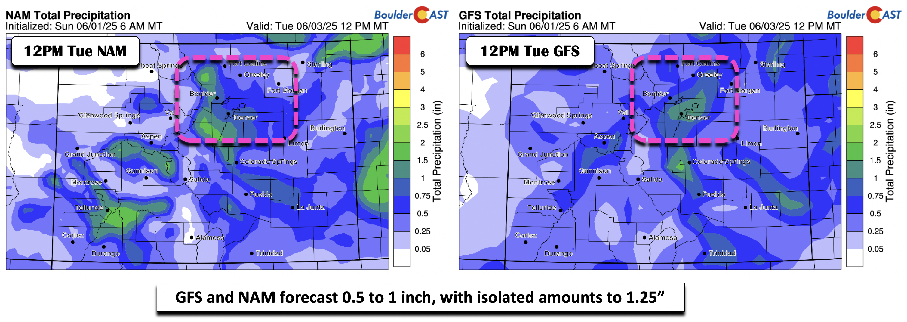
Let’s take a look at forecast rainfall totals among the guidance as there are some similarities and differences. The NAM and GFS below indicate anywhere from 0.5″ to 1″, with isolated totals upwards of 1.25 inches.
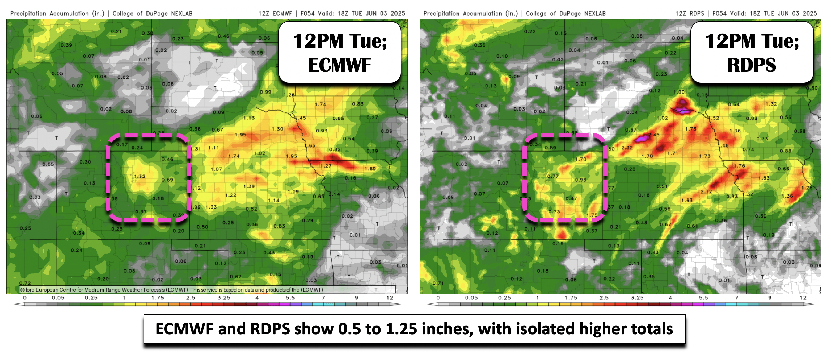
The ECMWF and RDPS (Canadian regional high-res model) show 0.5″ to 1.25″, with isolated higher amounts of 1.5″ in the Denver Metro area.
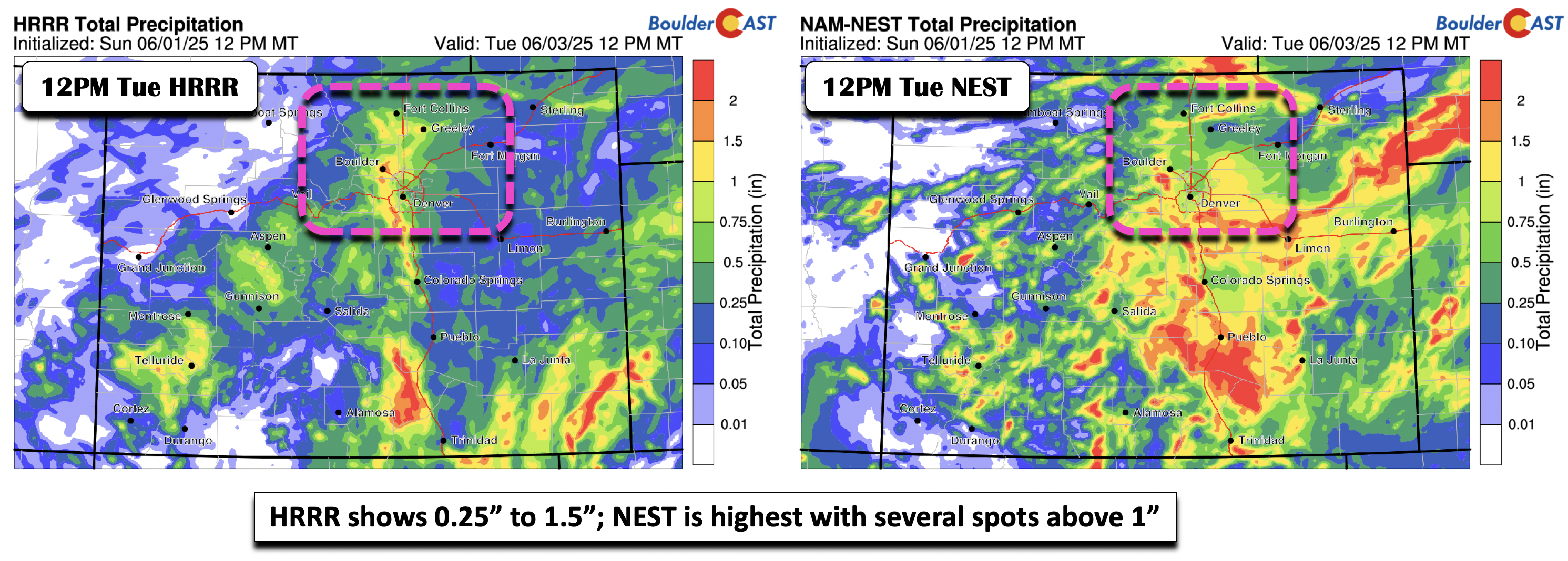
Looking lastly at the U.S. high-res models of the HRRR and NAM-NEST, amounts are not too dissimilar in the HRRR, indicating 0.25″ to 1.5″, highest along the eastern Foothills and Boulder County. The NAM-NEST is probably the highest compared to all of the guidance, with several locales above 1″ and a broad swath of 0.75″. Based on past experiences with this synoptic pattern and the general theme of the guidance, we’re expecting most areas to see 0.5″ to 1″ of rain by Tuesday evening. Certainly isolated totals of 1.5 inches will be possible, but pinpointing where that may occur is less certain (lower Foothills from Boulder southward looks most likely). All in all, it will be rather soggy here beginning Monday afternoon heading into early Tuesday. There could be a lull in action Tuesday during the day before some scattered showers return late Tuesday and Tuesday evening, mainly over the higher terrain.
Midweek and Beyond: More Rain Possible
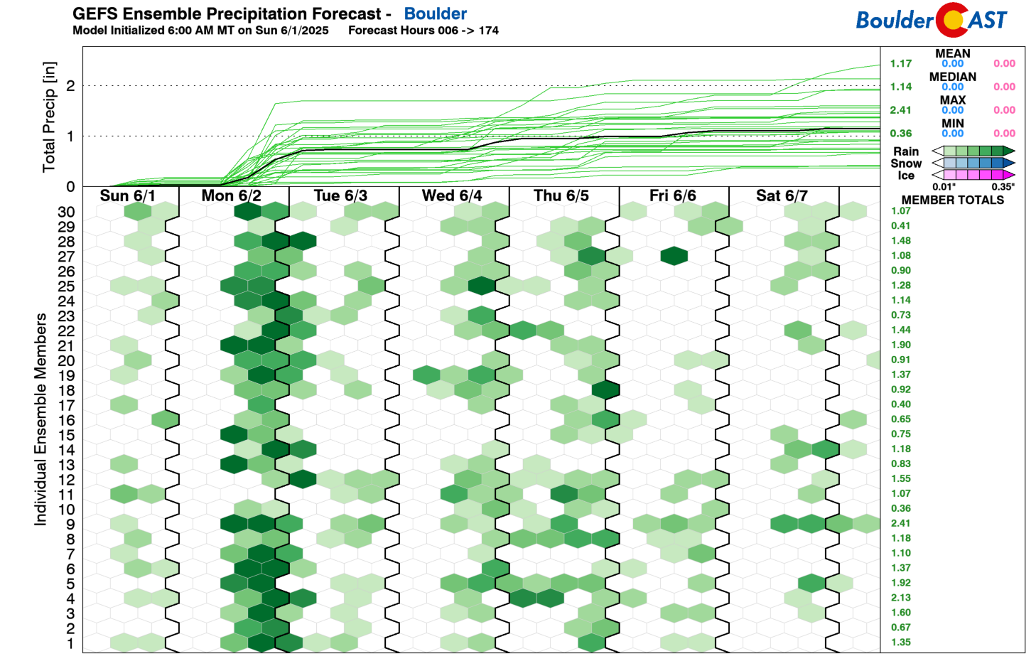
If you were hoping for a drier middle to latter part of the week, you might be disappointed. However, it does appear rain chances Wednesday onward are somewhat less certain as well as mainly diurnally-driven, focused on the late afternoon and evening hours each day. The GEFS ensemble shows the chances persisting through the remainder of the week, specifically Wednesday and Thursday, but as we will see in a bit, there is some questions on the overall pattern at this time.
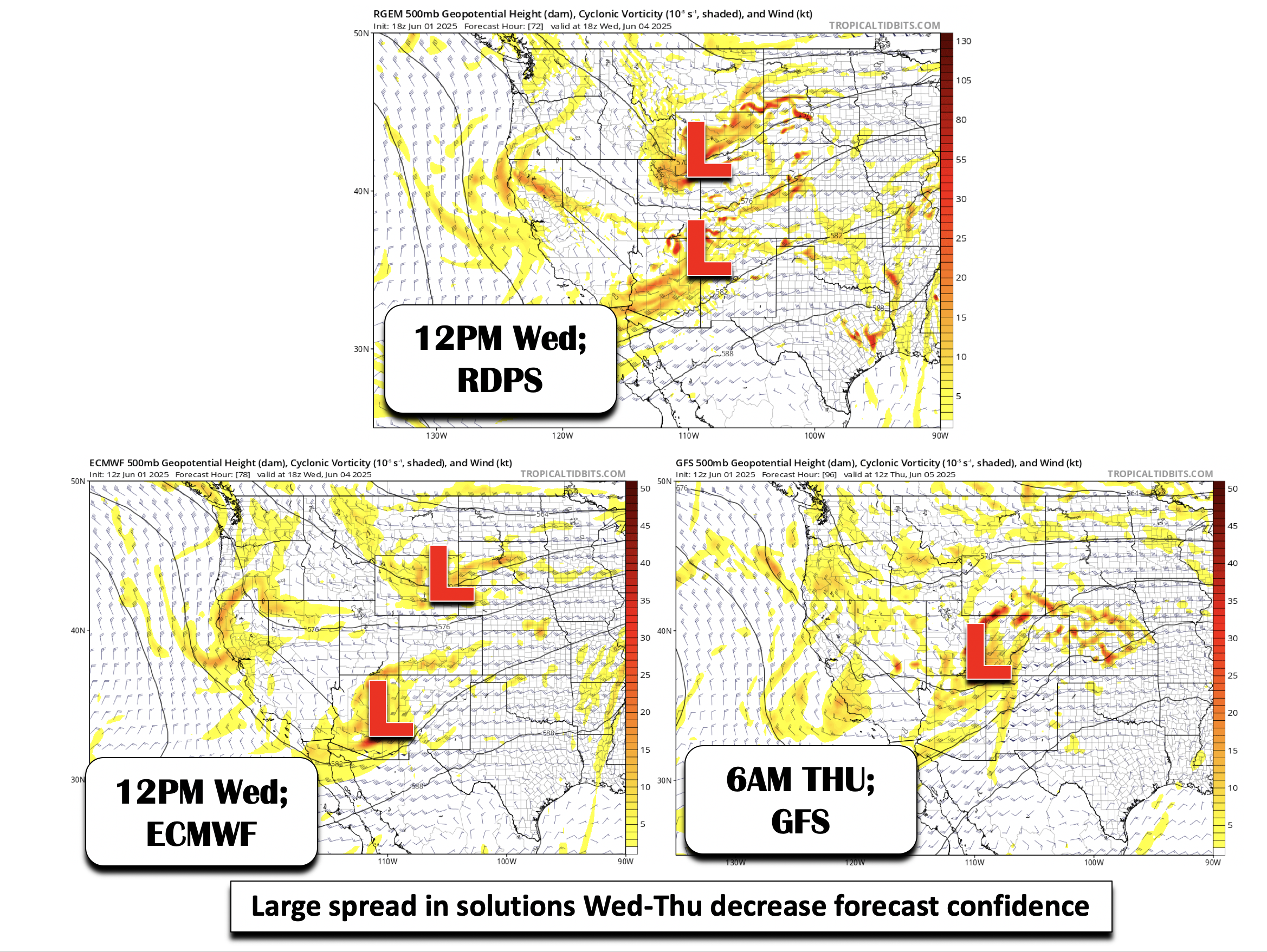
Earlier we mentioned the system off the California coast on Monday which would impact us midweek. The global models are quite different with its evolution and potential interaction with a northern wave. The RDPS shows its merging with a northern wave and promotes very high rain chances Wednesday afternoon/evening. The ECMWF, however, shows that the two systems remain relatively separate, with the northern wave weaker and the southern system skirting mainly to our south. The GFS is probably the most different — it waits until Thursday to bring the southern system into the state with broad troughing over the Great Basin. Suffice to say, the midweek period onwards is less certain, but expect those shower/storm chances to remain given the two disturbances that will be nearby in some fashion.
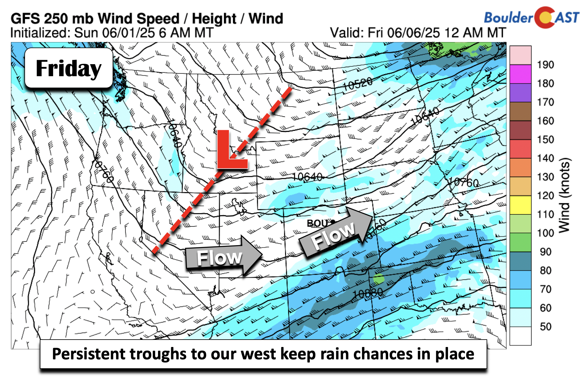
Much of the guidance also shows broad troughing to persist over the Great Basin through Friday, as shown via the GFS below. That should favor energy to bring afternoon/evening scattered showers and storms. There does not appear to be a clear severe weather signal any particular day, but future outlooks could include a severe storm threat given the strong flow aloft and time of year — we’re currently in peak severe weather season for eastern Colorado! As for temperatures, highs will remain below average mid to late-week in the 60s to lower 70s.
Here’s a look at the extended. The best chances for rain come Monday into early Tuesday, though depending on how things evolve later in the week, Wednesday and Thursday likely will also have excellent chances for more raindrops and claps of thunder. Enjoy what should turn out to be another fairly wet week!
Forecast Specifics:
Monday: Partly sunny skies becoming cloudy with scattered showers and storms developing in the afternoon and evening. A few storms may turn severe with damaging winds and hail up to half dollar sized. Widespread showers take hold through the overnight into early Tuesday morning. Highs in the lower 80s on the Plains and lower 70s in the Foothills.
Tuesday: Much cooler with showers and drizzle in the early morning, then a few scattered showers in the afternoon/evening redeveloping over the higher terrain. Highs in the upper 50s on the Plains to near 50 in the Foothills.
Wednesday: Partly sunny with scattered to numerous afternoon and evening showers and storms. Highs in the upper 60s on the Plains and middle 50s in the Foothills.
Thursday: Partly to mostly cloudy with scattered to numerous showers and storms. Highs in the mid to upper 60s on the Plains with upper 50s in the Foothills.
Friday: Partly cloudy with a chance of afternoon and evening showers and storms. Highs in the middle 60s to lower 70s, 50s in the Foothills.
Weekend: Uncertainty is higher, but storm chances look to persist with highs closer to normal in the upper 70s to lower 80s.
DISCLAIMER: This weekly outlook forecast is created Monday morning and covers the entire upcoming week. Accuracy will decrease as the week progresses as this post is NOT updated. To receive daily updated forecasts from our team, among many other perks, subscribe to BoulderCAST Premium.
Go Premium, get all the perks.
Daily Forecast Updates
Get our daily forecast discussion every morning delivered to your inbox.
All Our Model Data
Access to all our Colorado-centric high-resolution weather model graphics. Seriously — every one!
Ski & Hiking Forecasts
6-day forecasts for all the Colorado ski resorts, plus more than 120 hiking trails, including every 14er.
Smoke Forecasts
Wildfire smoke concentration predictions up to 72 hours into the future.
Exclusive Content
Weekend outlooks every Thursday, bonus storm updates, historical data and much more!
No Advertisements
Enjoy ad-free viewing on the entire site.
Enjoy our content? Give it a share!


You must be logged in to post a comment.