This week will feel a lot more like winter than any recent weeks in the Front Range, with several rounds of snow and cold temperatures sticking around throughout the extended. In this week’s outlook, we focus mainly on the widespread dump of fluffy snow knocking on the door for Monday evening into Tuesday, but we also touch on the lingering wintry weather set to unfold the rest of the week, including our coldest temperatures of the season so far and additional rounds of light snow possibly queueing up. Read on for all the details.
This week’s highlights include:
- Widespread Fluffy Snow Monday Night into Tuesday: A quick-moving storm will bring widespread accumulating snow to the Front Range early in the week. Snowfall totals of 2 to 7 inches are expected, highest south and west. Snow will end around midday Tuesday.
- Cold lingers: Temperatures will remain below normal throughout the week with highs only in the 20s and 30s. We’re likely to see our coldest temperatures of the season so far Wednesday morning (below 10°F).
- Snow Chances Aplenty: Several rounds of additional light snow will be possible in the extended — one during the day Thursday and another possibly on Saturday.
DISCLAIMER: This weekly outlook forecast is created Monday morning and covers the entire upcoming week. Accuracy will decrease as the week progresses as this post is NOT updated. To receive daily updated forecasts from our team, among many other perks, subscribe to BoulderCAST Premium.
Daily Forecast Updates
Get our daily forecast discussion every morning delivered to your inbox.
All Our Model Data
Access to all our Colorado-centric high-resolution weather model graphics. Seriously — every one!
Ski & Hiking Forecasts
6-day forecasts for all the Colorado ski resorts, plus more than 120 hiking trails, including every 14er.
Smoke Forecasts
Wildfire smoke concentration predictions up to 72 hours into the future.
Exclusive Content
Weekend outlooks every Thursday, bonus storm updates, historical data and much more!
No Advertisements
Enjoy ad-free viewing on the entire site.
Widespread fluffy snow Monday night into Tuesday
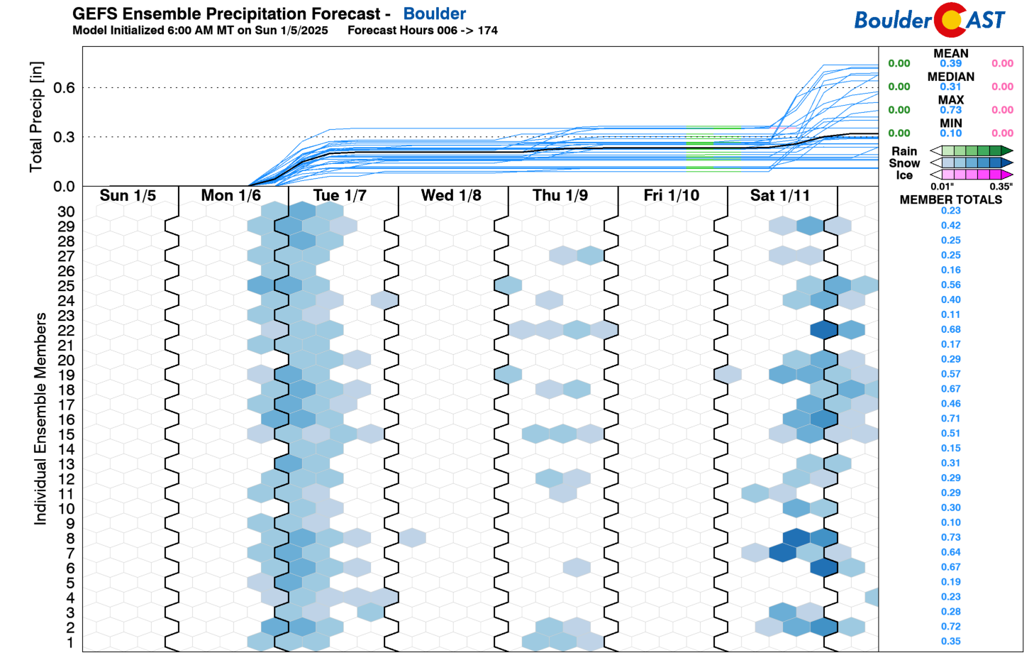
The first full week of 2025 will be an active one with cold temperatures and several rounds of snow possible across the Front Range. Let’s get into it! The GEFS precipitation plume forecast is indicated below. It shows that we have three distinct chances of snow this week. The first comes Monday night into about midday Tuesday. A second round could occur on Thursday, while yet a third might come during the weekend on Saturday. Out of all three, the first one on Monday is the most certain for widespread accumulating snow up and down the Front Range from Cheyenne to Pueblo!
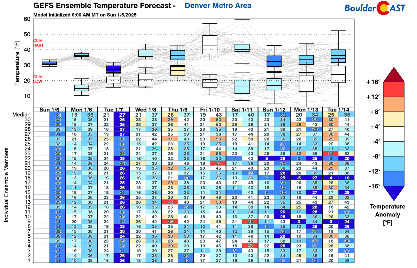
Along with the snow chances, our temperatures will largely hover below normal in the 30s this week, with some 20s also mixed in for Tuesday with fresh snow on the ground. We may get closer to average later in the week but it likely won’t last with continued waves of reinforcing cooler air expected. This is all due to a persistent cold northwest flow setting up over the region.
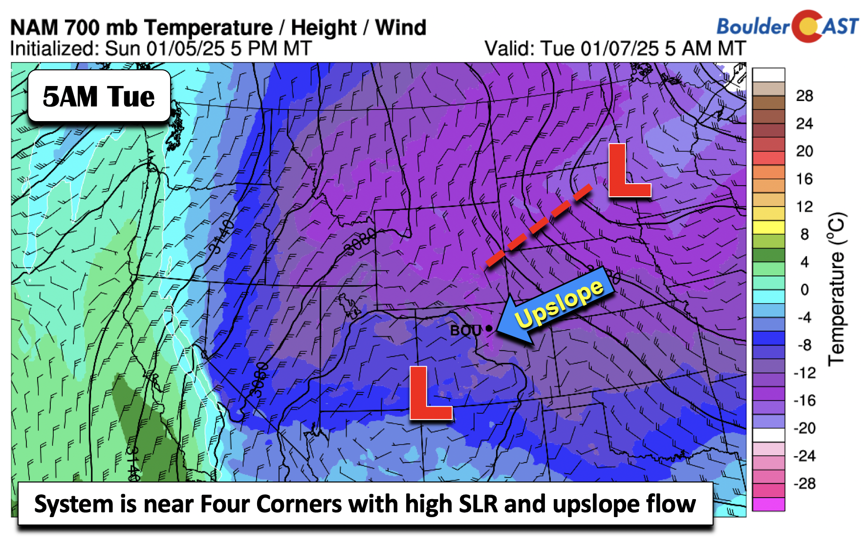
Monday’s system that will bring the widespread snowfall to the area is an interesting one. If one were to look at the mid-levels, the shortwave low pressure is actually over the Nevada/Utah line, well to the west of Colorado. However, the system that will be responsible is actually at the 700 mb pressure level, about 5000-8000 feet above the surface. That low pressure will track northwest to southeast into the Four Corners area by early Tuesday morning. While this is still somewhat far removed, it will bring in a broad area of upslope from late tonight into midday Tuesday. A nice influx of cold air will also be in place, setting the stage for some higher than average snow-to-liquid ratios (SLRs). Unfortunately, for the snow-lovers reading this, there does not appear to be jet streak in place for any jet-forced snow bands. This makes the forecast easier for us, but the BOOM potential with this system is fairly low!
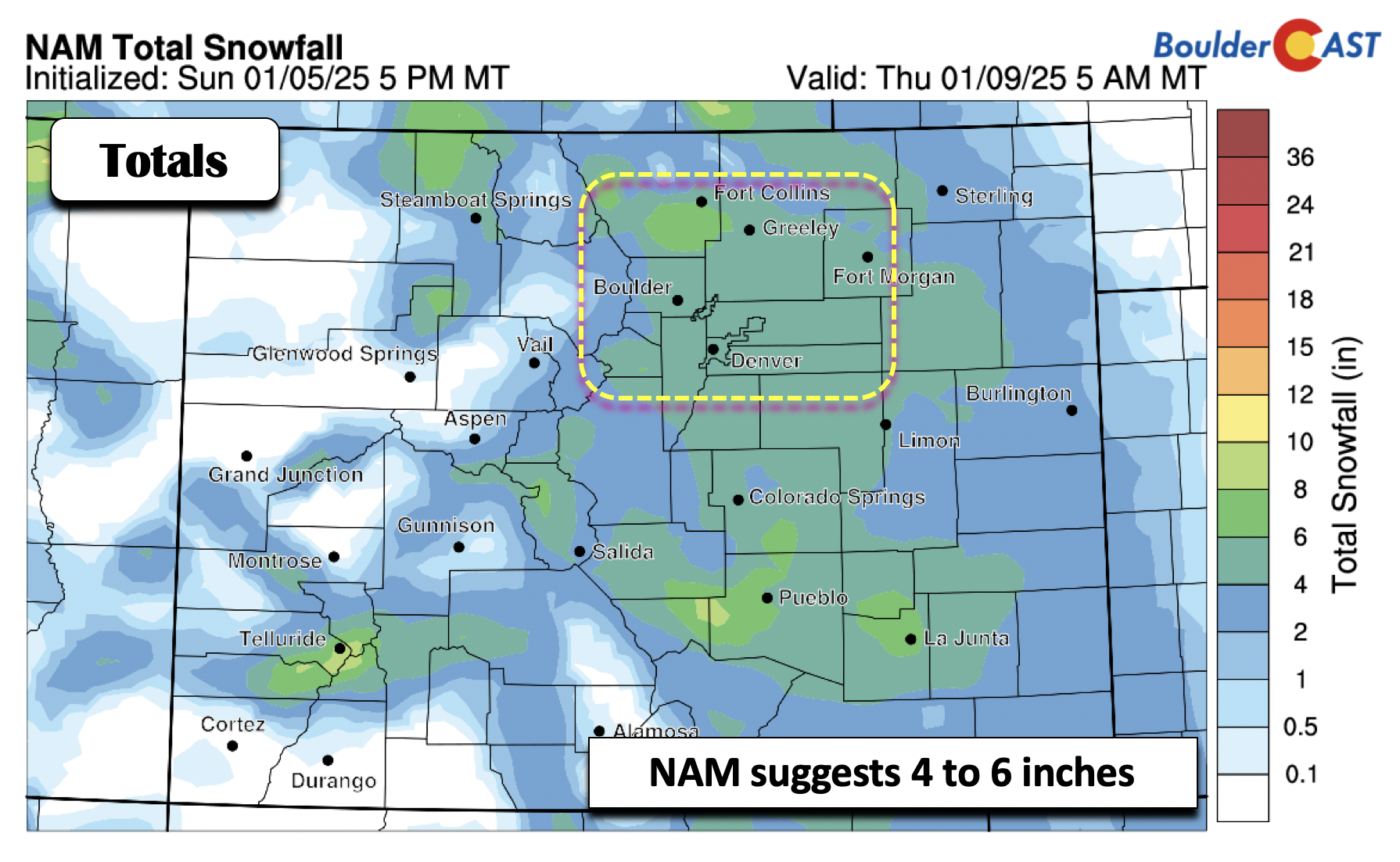
The regional and high-res models are actually in excellent agreement with snowfall totals this time (hooray!). We’ll show all three so you can see the consistency. The NAM below shows a broad swath of 4 to 6 inches across the entire Metro area. These plots use our in-house SLR algorithms, which do indeed account for the anticipated higher SLR ratios (i.e fluffy snow).
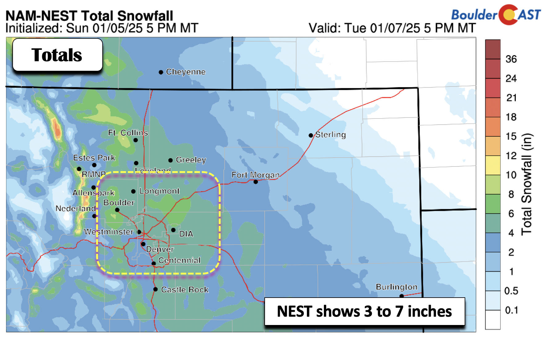
The child version of the NAM, the NAM-NEST, shows a similar amount, with perhaps some 7+ inch totals in the Foothills and in western Boulder and parts of the Denver Metro area.
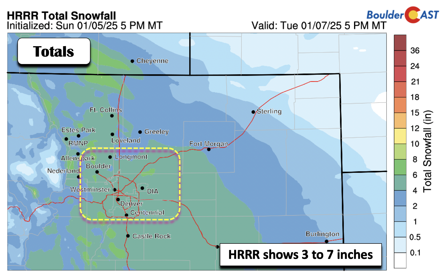
The HRRR is also very similar to the prior NAM-NEST, with 3 to 7 inches falling across most of the area. So as you can see, all the usual models are on-board for a light to moderate blanketing of snow Monday night!
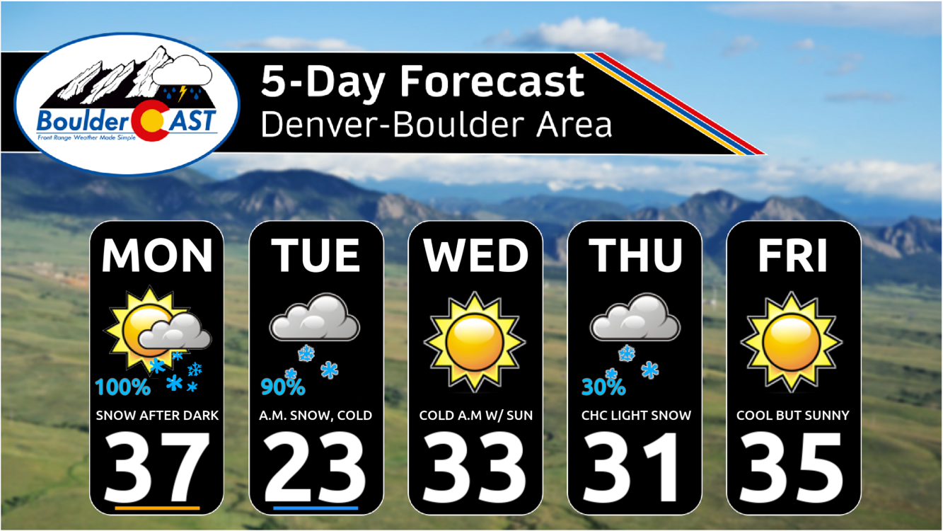
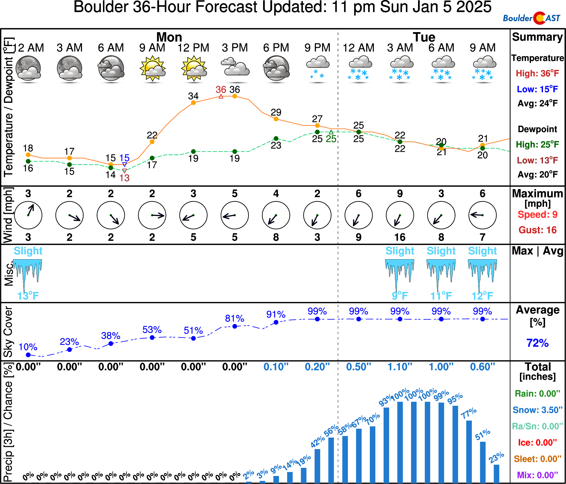
Let’s get into the official BoulderCAST forecast! Highs on Monday will be in the mid to upper 30s with a mix of clouds and sun through the day. Cloudcover will really increase through the afternoon ahead of the storm. By evening, light snow chances will enter the picture, but widespread light snow is not expected to arrive until late evening. Snow will continue through the night and Tuesday morning, tapering off around midday on Tuesday.
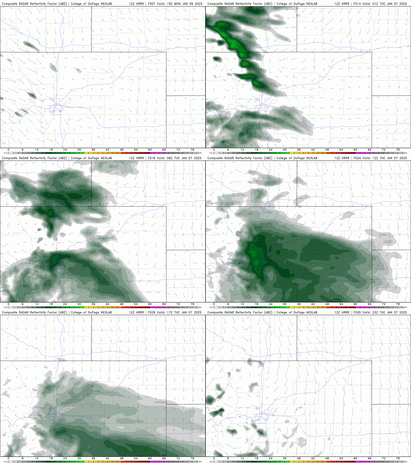
The high-resolution models, including the HRRR below, show some localized enhancement early Tuesday morning from Boulder County southward thanks to a small-scale Denver Cyclone feature. Can you pick out the simulated radar signature of this below? It looks like a mini snow hurricane forming over the Denver area! Whether this actually happens or not remains to be seen, but either way we are expecting a bump in snowfall intensity during the early morning hours due to several complementary factors which will make for a slippery Tuesday morning commute!
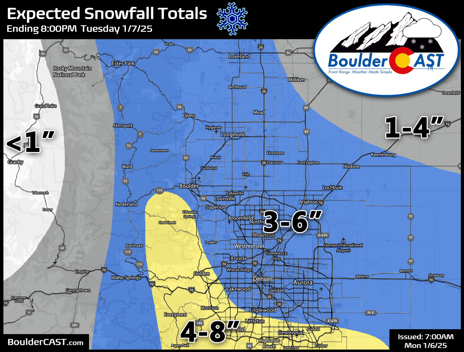
Expected snowfall totals are in the 3 to 6 inch range across the entire Denver Metro area, with some locally higher totals possible in southern and southwest Denver where upslope will be best and possible enhancement from the Denver Cyclone feature may occur. Less than 4″ of snow is expected northeast of Denver and in the Mountains.
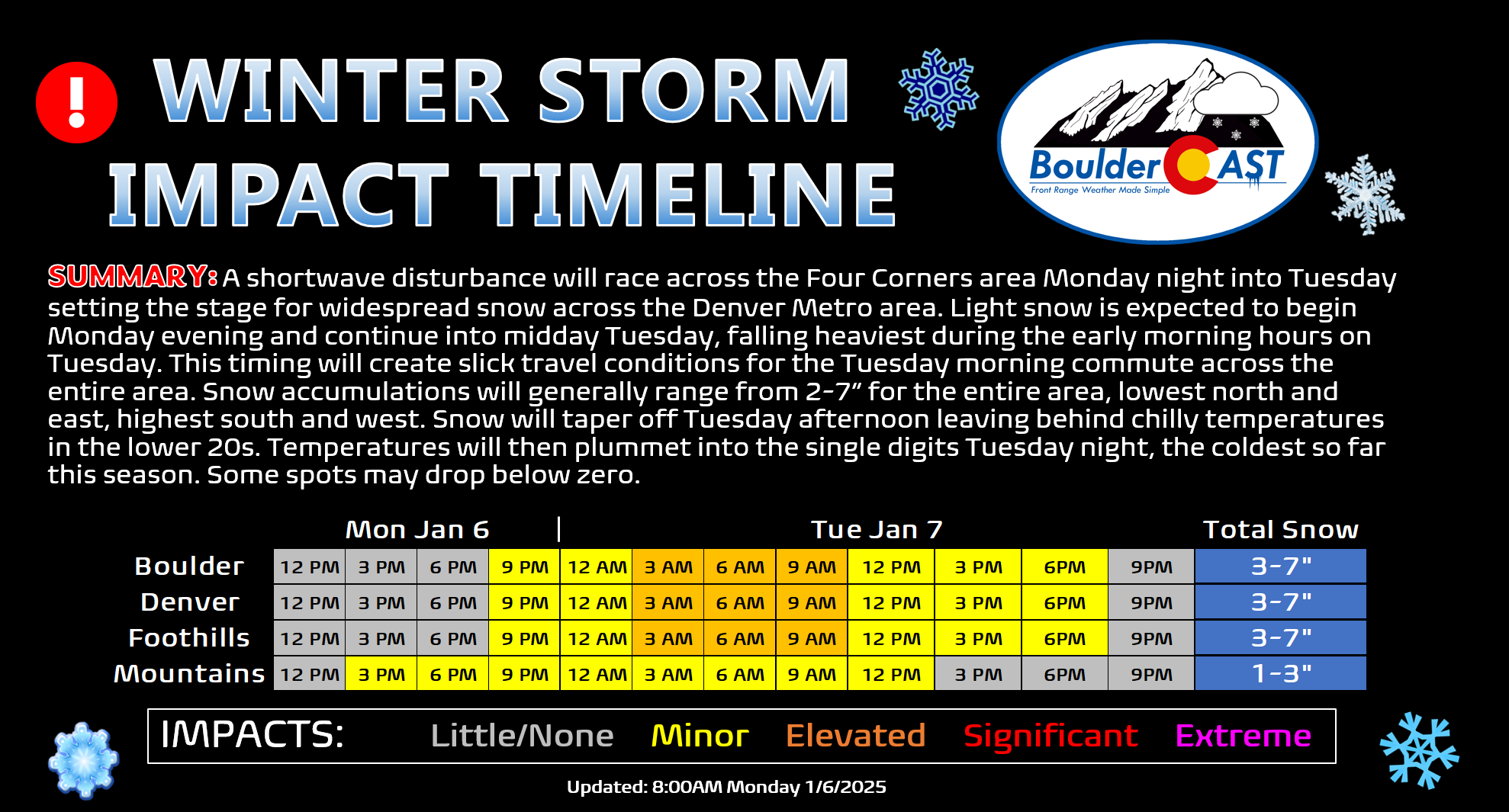
Travel impacts will be widespread Tuesday morning. If you can, we recommend working from home. Otherwise, try to at least delay heading out on the roadways to give crews time to clear the bulk of the snow. It’s going to be a very slow go of things regionwide with slick and snow-covered roadways all but guaranteed in all locations! Travel should start to improve through the afternoon on Tuesday as the snow comes to an end.
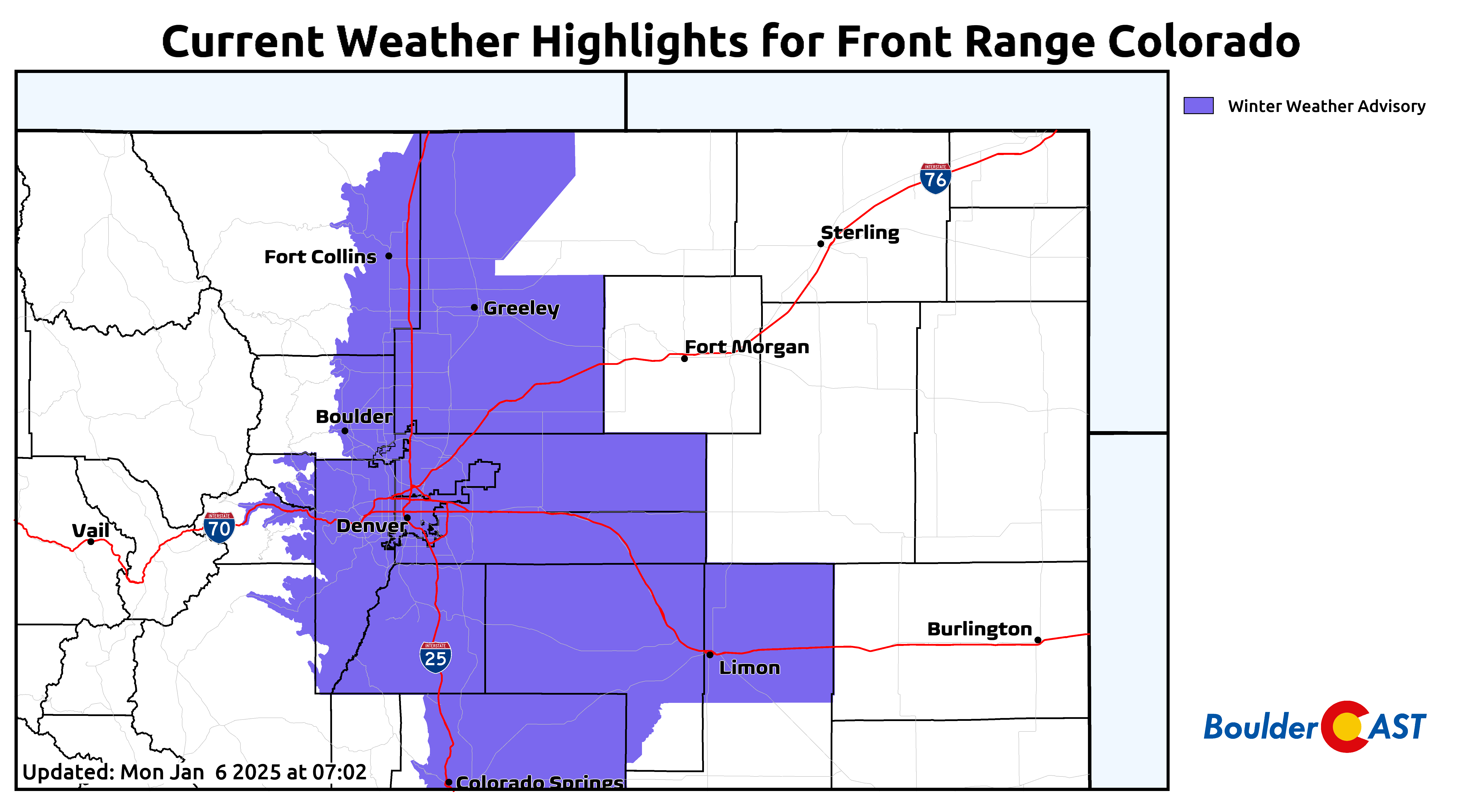
Winter Weather Advisories are posted for the entire Interstate 25 Corridor from Cheyenne to Pueblo in anticipation of the light but fluffy snow disrupting travel early Tuesday. You have been warned!
Light snow will begin Monday evening across the area, increasing in coverage/intensity during the early morning hours Tuesday. A slow & slick morning commute is expected everywhere! ☃️🚗💥
Here's the latest numbers. Most places can expect 2 to 6 inches of absolute fluff! #COWX pic.twitter.com/z3DItvE0fa
— BoulderCAST Weather 🏔️❄️ (@BoulderCAST) January 6, 2025
The rest of the week stays chilly with snow chances
Temperatures will be rather cold with the fresh snow on Tuesday — we won’t get out of the 20s anywhere in the Front Range with temperatures mostly hovering in the low to middle 20s. Furthermore, very cold readings will develop Tuesday night under light winds and clear skies, with lows diving into the single digits for the lower elevations and perhaps even below zero in the typical cold spots. This should be our coldest morning of the season so far. We really haven’t had that much cold air yet this winter. Boulder’s lowest temperature to-date was only 13°F back on December 10th — that will most likely get bested Wednesday morning!
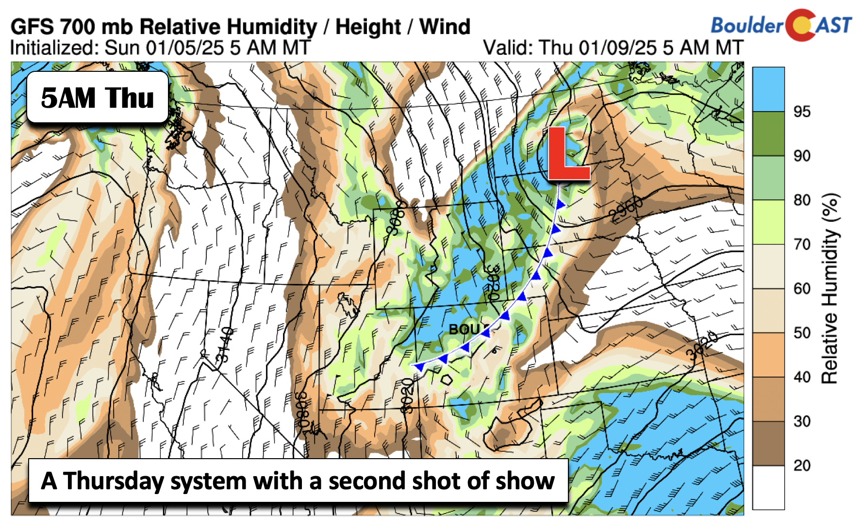
After quiet weather on Wednesday (sunny and highs just above freezing), clouds will increase again ahead of our next potential system come Thursday. This secondary system is predicted to be located well to our northeast, but with another cold front coming southward. This one for sure has more uncertainty than Monday’s, but it will bring in a period of upslope yet again with enough moisture to possibly produce light snow in the area. Right now, it’s too early to talk about specific amounts, but our first guess is that it looks minor at this point — definitely less so than Monday night’s snow.
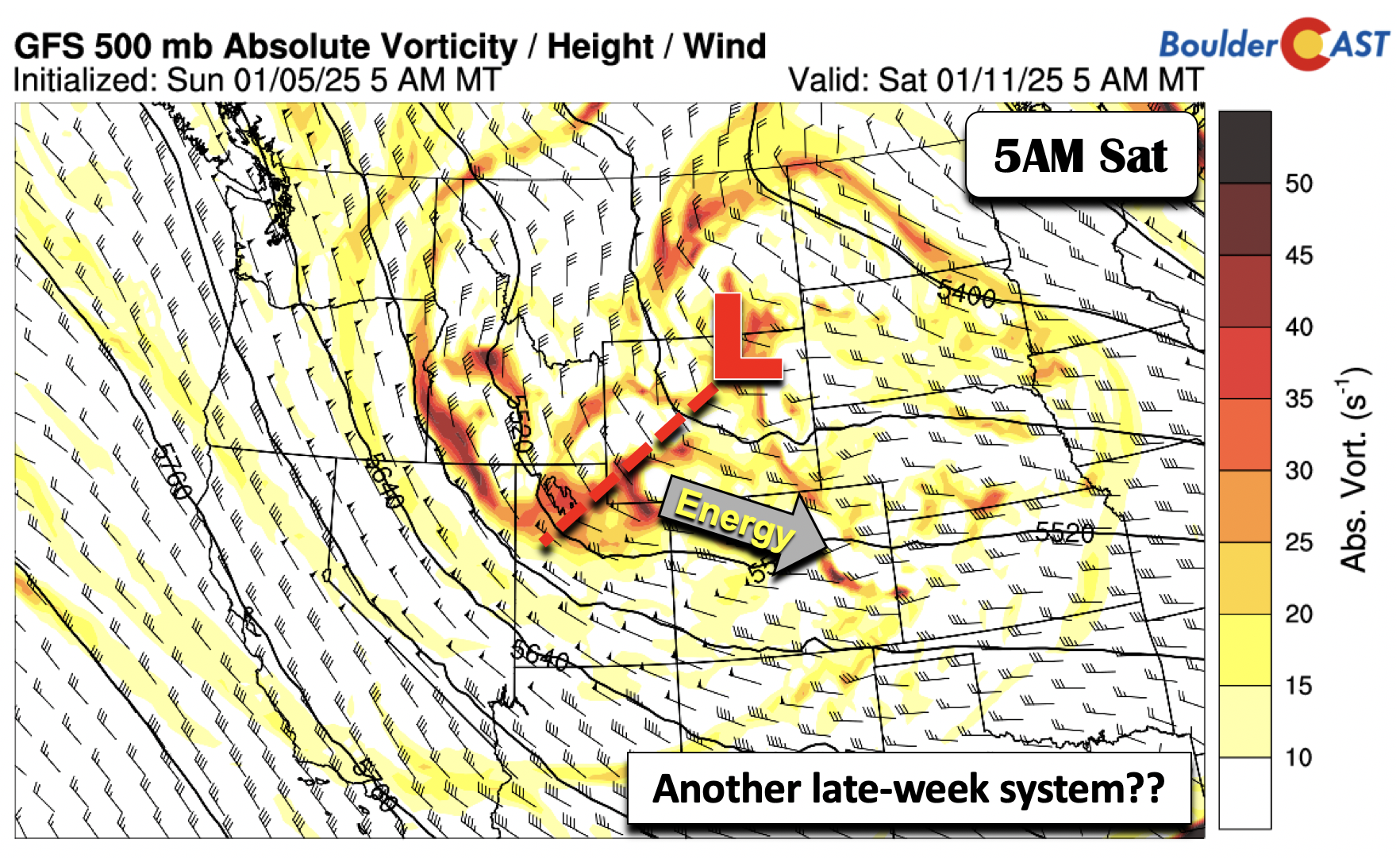
After Thursday’s system, the atmosphere stays active as yet another storm system is forecast to dive down in the northwest flow. This takes a favorable track, but its location is not in agreement amongst the ensemble guidance this far out. Nevertheless, several members show the chance of snow, so it bears watching for now.
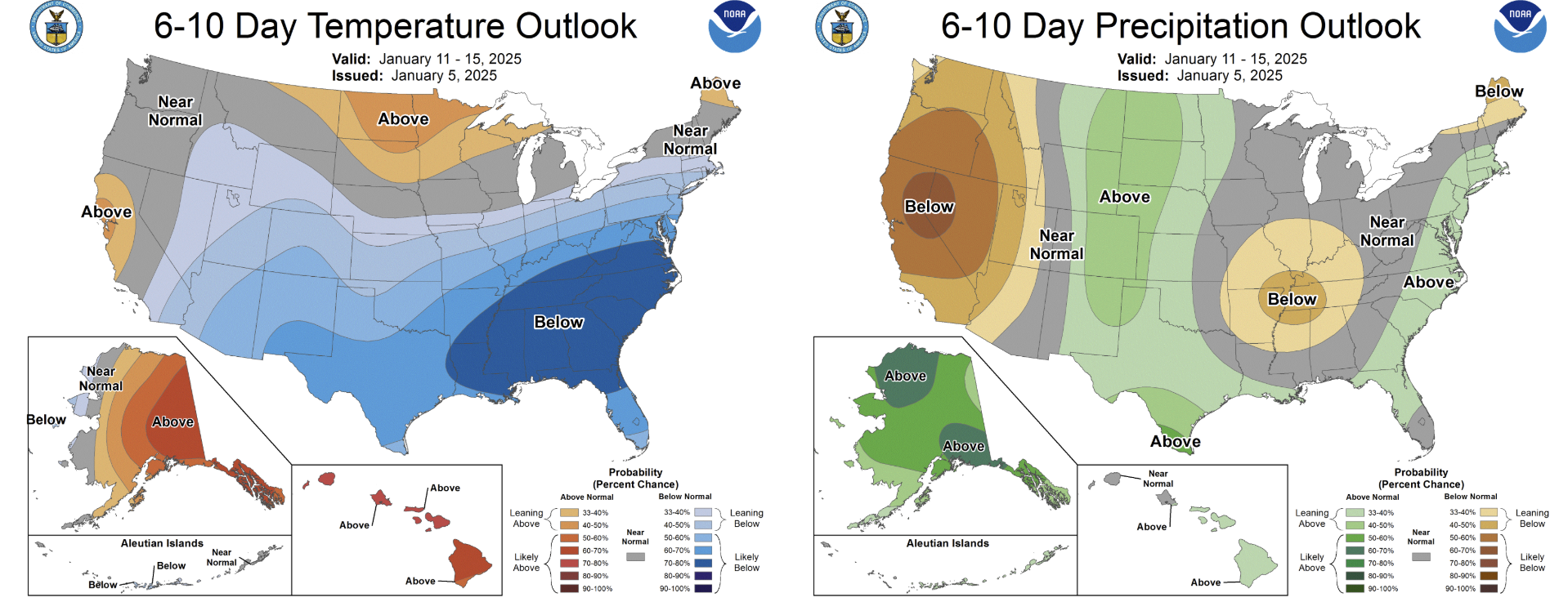
The pattern should keep us cold to start the weekend and even into early next week.
Stuck in a rather warm and dry setup the last several months, we’ve heard the incessant cries for colder and snowier weather the last few months from the community. Well, now you’ve got it. Enjoy!
Forecast Specifics:
Monday: Partly cloudy with snow developing during the evening and continuing through the overnight. Snow may be moderate to heavy at times in the wee morning hours. Highs in the mid to upper 30s for the Plains and upper 20s in the Foothills, dropping into teens at night as snow falls..
Tuesday: Widespread light to moderate snow in the morning, tapering off by midday. The AM commute will be very slow regionwide! Total accumulations of 3 to 7 inches are expected. Highs in the middle 20s on the Plains and mid to upper teens in the Foothills.
Wednesday: Mostly sunny and warmer but still chilly in the low to middle 30s for the Plains and lower 20s in the Foothills.
Thursday: A chance of snow under mostly cloudy skies. Highs in the lower 30s for the Plains and lower 20s in the Foothills.
Friday: Lots of sun with highs in the mid to upper 30s in the Denver Metro and upper 20s in the Foothills.
Weekend: A return chance of snow is possible (but uncertain) for Saturday, with continued below normal temperatures through the weekend.
Get BoulderCAST updates delivered to your inbox:
DISCLAIMER: This weekly outlook forecast is created Monday morning and covers the entire upcoming week. Accuracy will decrease as the week progresses as this post is NOT updated. To receive daily updated forecasts from our team, among many other perks, subscribe to BoulderCAST Premium.
Daily Forecast Updates
Get our daily forecast discussion every morning delivered to your inbox.
All Our Model Data
Access to all our Colorado-centric high-resolution weather model graphics. Seriously — every one!
Ski & Hiking Forecasts
6-day forecasts for all the Colorado ski resorts, plus more than 120 hiking trails, including every 14er.
Smoke Forecasts
Wildfire smoke concentration predictions up to 72 hours into the future.
Exclusive Content
Weekend outlooks every Thursday, bonus storm updates, historical data and much more!
No Advertisements
Enjoy ad-free viewing on the entire site.
Enjoy our content? Give it a share!




You must be logged in to post a comment.