After a weak cold frontal passage last evening, we are mostly tranquil for today outside of a few spotty afternoon storms in Boulder County. The weather this week will feature another warmup into the 80’s. By late week, we turn to a cooler and unsettled weather pattern.
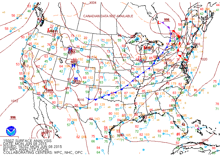
The current surface analysis map below shows an area of high pressure over western Colorado. The cold front which pushed through last night is now off to our east stretching from Oklahoma, through Missouri, and into the Great Lakes.
Today through Friday, the forecast for our region will focus on three upper-level low pressure systems that will impact Colorado. These three systems are shown in the below water vapor satellite image as of this Monday morning. The first system is located over southeastern Nevada and will impact parts of Colorado today and tomorrow. A second low pressure system is located over Baja California. This is Tropical Storm Blanca (formerly a major hurricane) and will impact our region Wednesday. Finally, a third system over the Pacific Ocean will move ashore into California Wednesday and impact our region Thursday night into Friday.
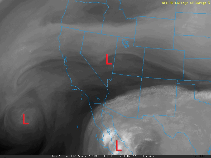
Three upper-level low pressure systems to impact Colorado this week, shown on this water vapor image as of Monday
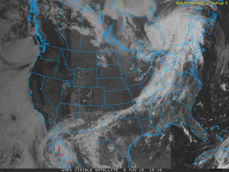
A more detailed view of the nation’s weather is shown in the visible satellite image below. It shows Tropical Storm Blanca, as well as the clearing skies behind the cold front from the Great Plains westward into Colorado and Utah.
The impact of these three systems on temperatures and precipitation will be discussed. The 500 mb absolute vorticity map from the GFS for this Monday is shown below. It depicts two of the low pressure systems. The pattern shows a trough located to our east from the Midwest into the Great Lakes. To our west is the low pressure system over Nevada. And over Colorado, we are in relatively weak upper-level flow. This area of weak flow is sometimes referred to as a Col region, where there is little wind shift or forcing. With that, expect today to be tranquil with highs in the lower 80’s. The low pressure system to our west will also help produce some isolated afternoon storms as a weak valley breeze (slight upslope flow) ensues along with the lift from the vorticity advection. All things considered though, these should be spotty this afternoon/evening with most of us staying dry as there is little to no instability in place.
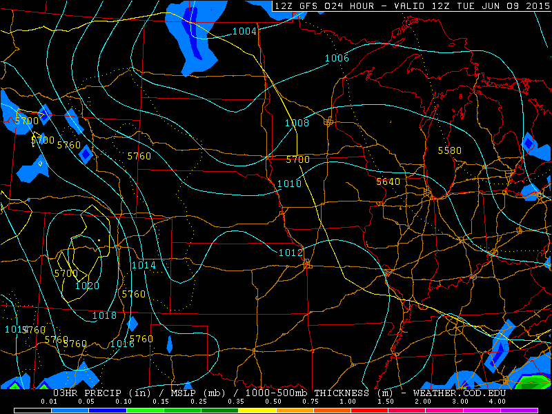
Going into Tuesday, we will be under a westerly downslope flow. With warm temperatures at 700 mb, highs will be above average into the upper 80’s. The plot below shows the sea-level pressure contours in light blue and precipitation shaded from the GFS model. This forecast shows an area of high pressure over western Colorado and a lee trough over eastern Colorado, which together are conducive for downslope warming. Expect lots of sunshine again tomorrow. With the system over Utah still around and moisture slowly advecting in from the southwest from the remnants of Tropical Storm Blanca, a few very isolated storms can’t be ruled out, but overall dry for Boulder County.
On Wednesday, tropical moisture streams northeastward into Colorado from the remnants of Tropical Storm Blanca. Vorticity advection, which aids in lift for precipitation, will also help increase chances of isolated to scattered afternoon storms across our region. As this point, it appears the best chance of storms Wednesday would be across the foothills of Boulder County as the city of Boulder looks to still be under a relatively downslope flow. Temperatures will also be a little cooler under cloud cover but still into the 80’s on the Plains.
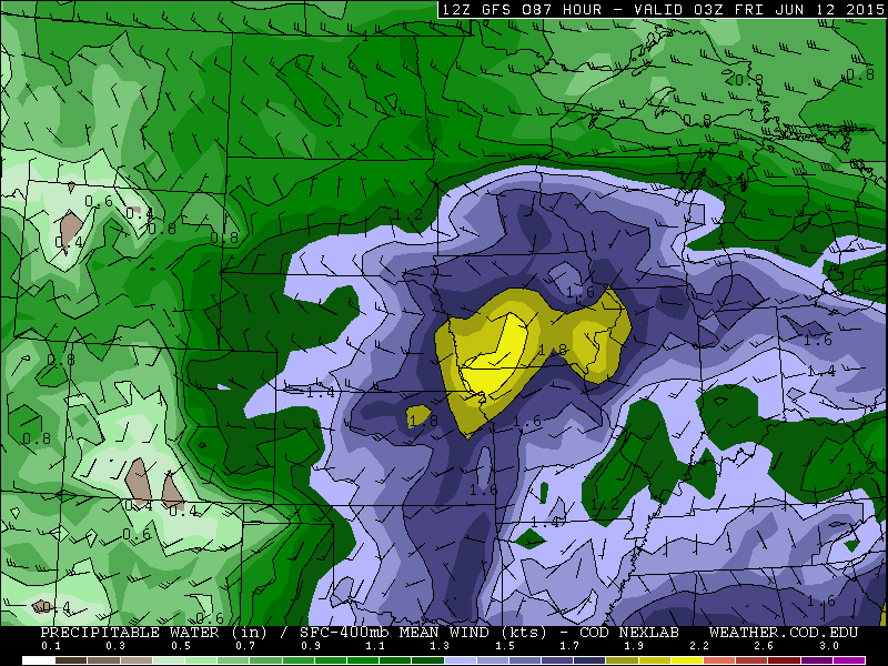
The large trough of low pressure over the Pacific Ocean makes it way into Colorado late in the day Thursday and may stick around the region into Friday as well. Right now, it’s too far out to tell how long this system will linger over Colorado. The current forecast models show it could last into Saturday. However, these details will get ironed out as the week progresses, so expect a slight changes in the forecast as we go into Friday. The 500 mb vorticity map for Thursday evening from the GFS model shows the area of low pressure over southwest Colorado and eastern Utah with plenty of lift ahead of it over eastern Colorado. Coupled with this upper-level forcing will be: 1) low-level upslope flow due to an approaching cold front, 2) increasing moisture Thursday into Friday with precipitable water values above 1 inch, and 3) instability.
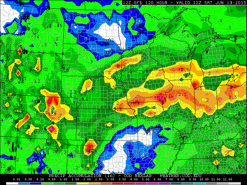
As mentioned earlier, the forecast becomes more difficult Thursday night into Friday, depending on the track and speed of the low pressure system currently over the Pacific Ocean. A few things are clear at this point: we will see rain and temperatures will be cooler. How cold and how much rain is the tough part at this point, so be sure to keep your focus here on BoulderCAST for an update by late week. The forecasted total rainfall Thursday night into Friday from the GFS have parts of Boulder County receiving 2-3 inches of rain. This forecast is likely to change, but it shows you the potential for a wet end of the week. This system also has the capacity to dump more mountain snow to the highest peaks above 12,000 feet Thursday night into Friday.
Forecast for Boulder County:
Today: Mostly sunny skies across Boulder with a few widely isolated storms in the late afternoon/early evening. Overall dry though with temperatures in the lower 80’s in the city of Boulder, with middle 70’s in the foothills.
Tuesday: Lots of sunshine, temperatures close to the upper 80’s in the city of Boulder with lower 80’s in the foothills. A few widely isolated storms cannot be ruled out, but overall a dry day.
Wednesday: Sunshine giving way to increasing clouds in the mid to late afternoon. Isolated to scattered storms in the Foothills with temperatures in the middle 70’s. In the city of Boulder, temperatures low to middle 80’s with isolated storms in the afternoon/early evening
Thursday: Sunshine to become cloudy with increased rain chances, with some storms possible as well, by evening and overnight. Temperatures in the upper 70’s, with low 70’s in the Foothills.
Friday: Forecast more uncertain for this day. Mostly cloudy with a good chance of rainfall and highs in the middle 60’s in Boulder and upper 50’s in the Foothills.







You must be logged in to post a comment.