After a weekend of scorching late September heat and new record highs, the warmth continues for Monday. However, our coldest weather of the season is knocking on the door thanks to a strong cold front and a series of low pressure systems that will target Colorado this week. When will the changes occur and will there be any rain or snow to speak of? Read on for our complete outlook of the week ahead.
This week’s highlights include:
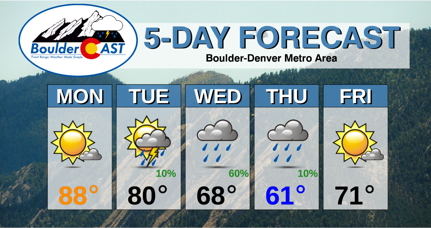
- One last very warm day for Monday before temperatures fall for the rest of the week
- Highs only in the 60’s come mid-week and staying below average through Friday
- Chance of rain Tuesday through Thursday
- Weak ridging, seasonal temperatures, and drier weather for the upcoming weekend
DISCLAIMER: This weekly outlook forecast is created Monday morning and covers the entire upcoming week. Accuracy will decrease as the week progresses as this post is NOT updated. To receive daily updated forecasts from our team, subscribe to BoulderCAST Premium.
A look at the week
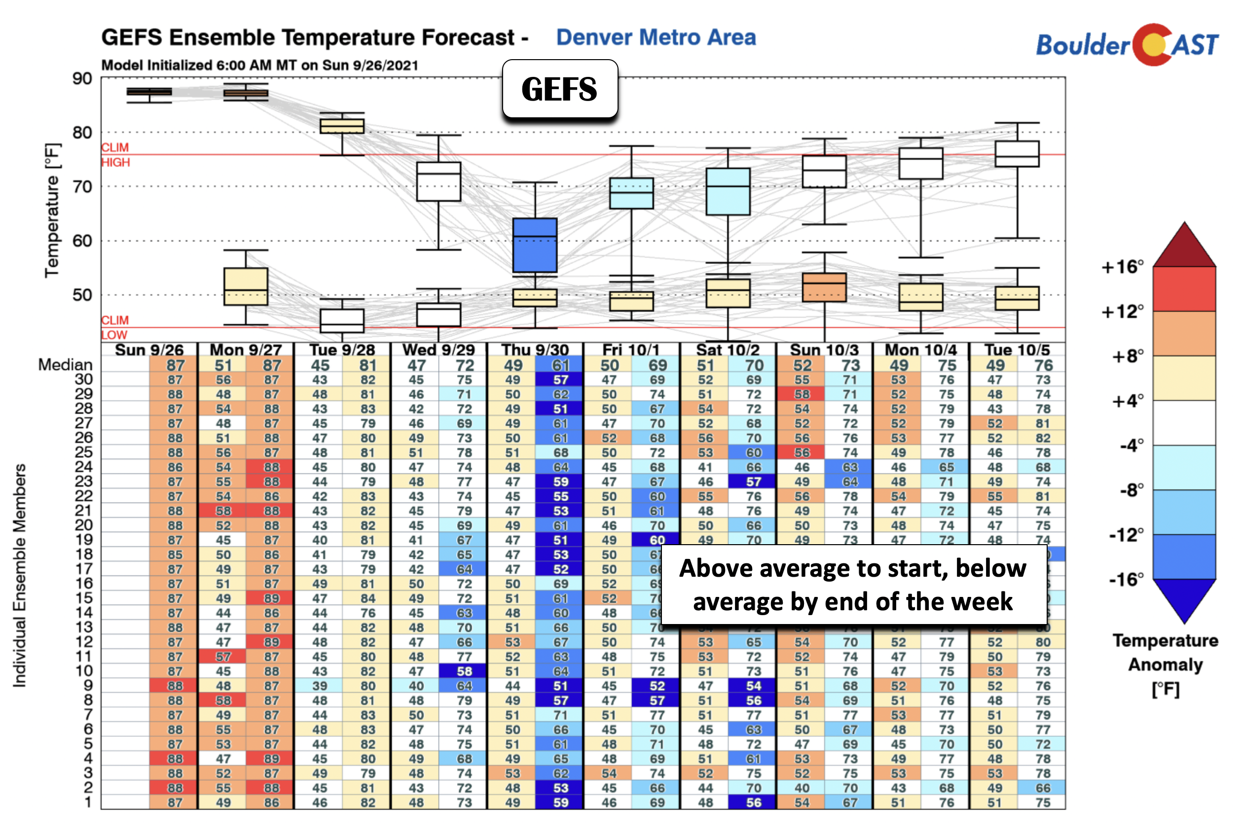
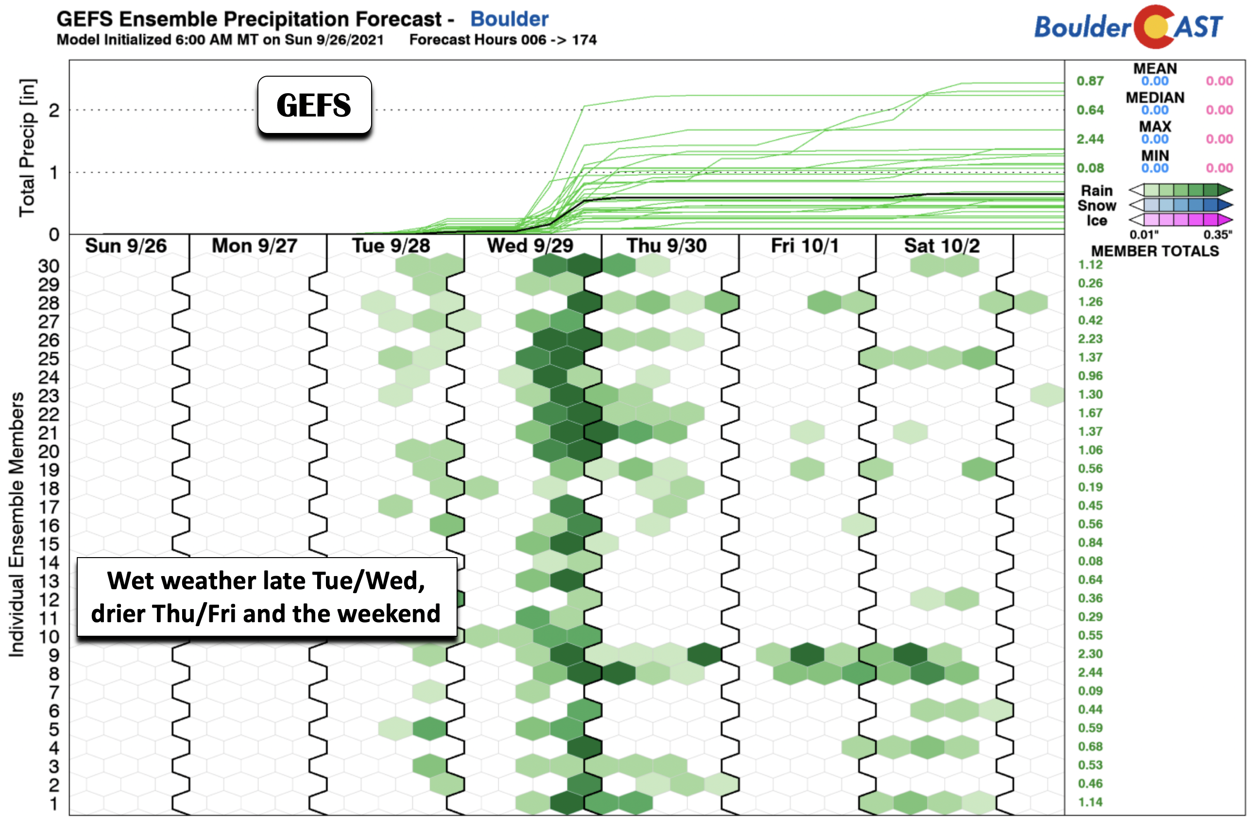
The two images below highlight the overall trend in temperatures and precipitation for the week ahead across the Denver Metro area. If there are any main themes that stick out, it is the trend from the unseasonably warm weather we have had the last several days, to well below average temperatures by the middle of the week with highs only in the 60’s. A gradual return to more seasonal weather is expected by the weekend.
As you can probably guess, the transition from warm to cold likely involves a fall weather feature…. in this case a cold front and a series of low pressure systems. Looking at the GFS ensemble precipitation forecast below, the front and low pressure approach late Tuesday into Wednesday. This also happens to be the best likelihood for rainfall on the Plains. The Mountains will see their fair share today through Wednesday as well, but the Plains will be trailing about one day behind.
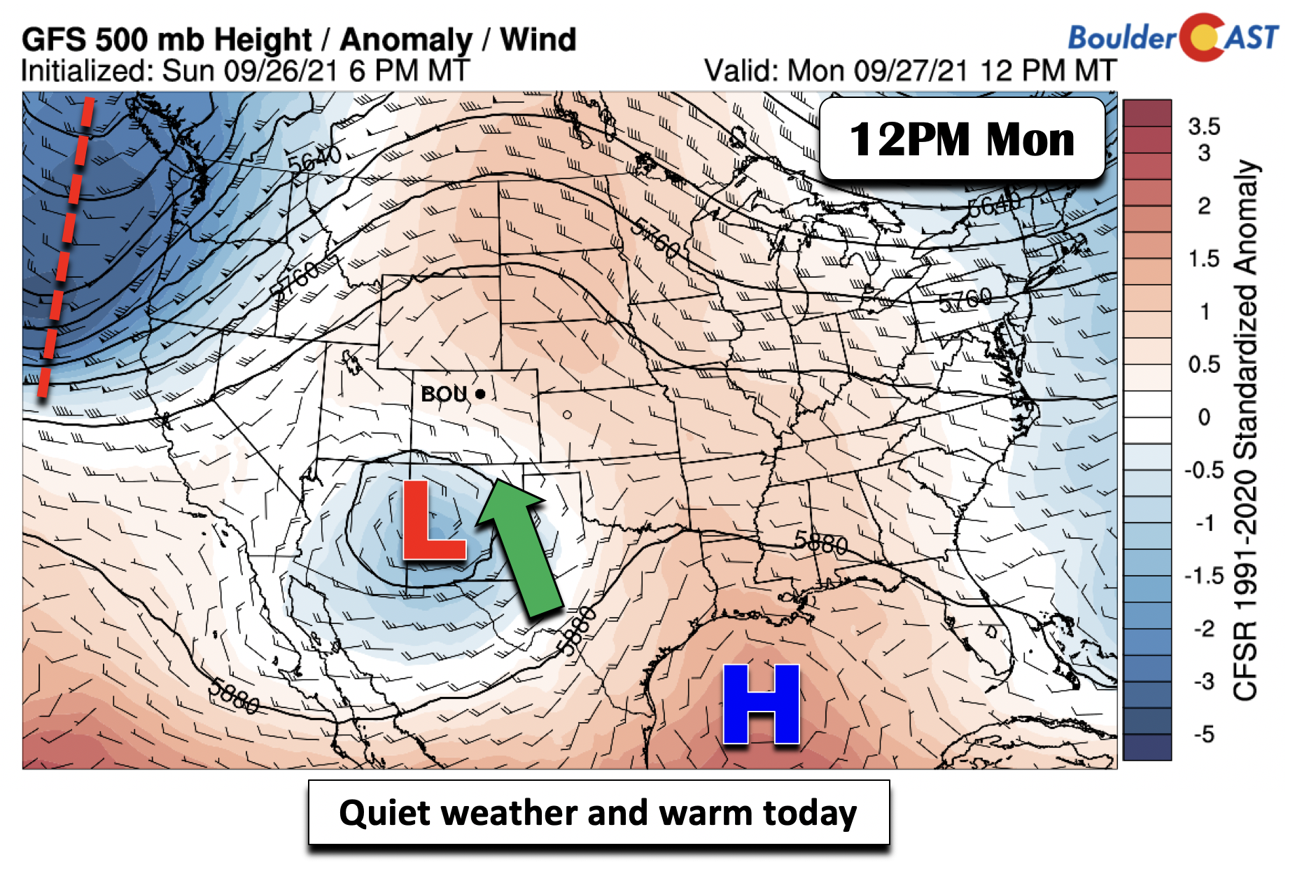
Quiet today but active midweek
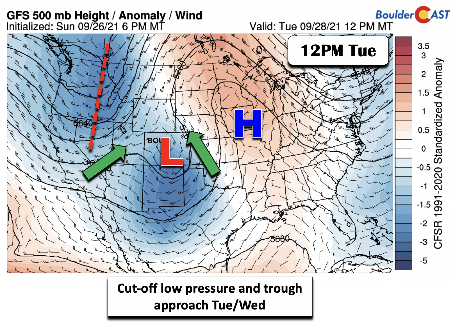
What is causing this change? There are mainly two factors. As of Monday morning, there is a cut-off area of low pressure sitting to our south in New Mexico. This system will be moving north tonight and tomorrow, bringing clouds, increased moisture, and tying everything together will be a little upslope. At the same time, there is going to be a trough axis moving onshore into the Pacific Northwest. This trough will approach the area early Wednesday and the two systems will more or less combine and interact over Colorado to produce wet weather and cooler temperatures.
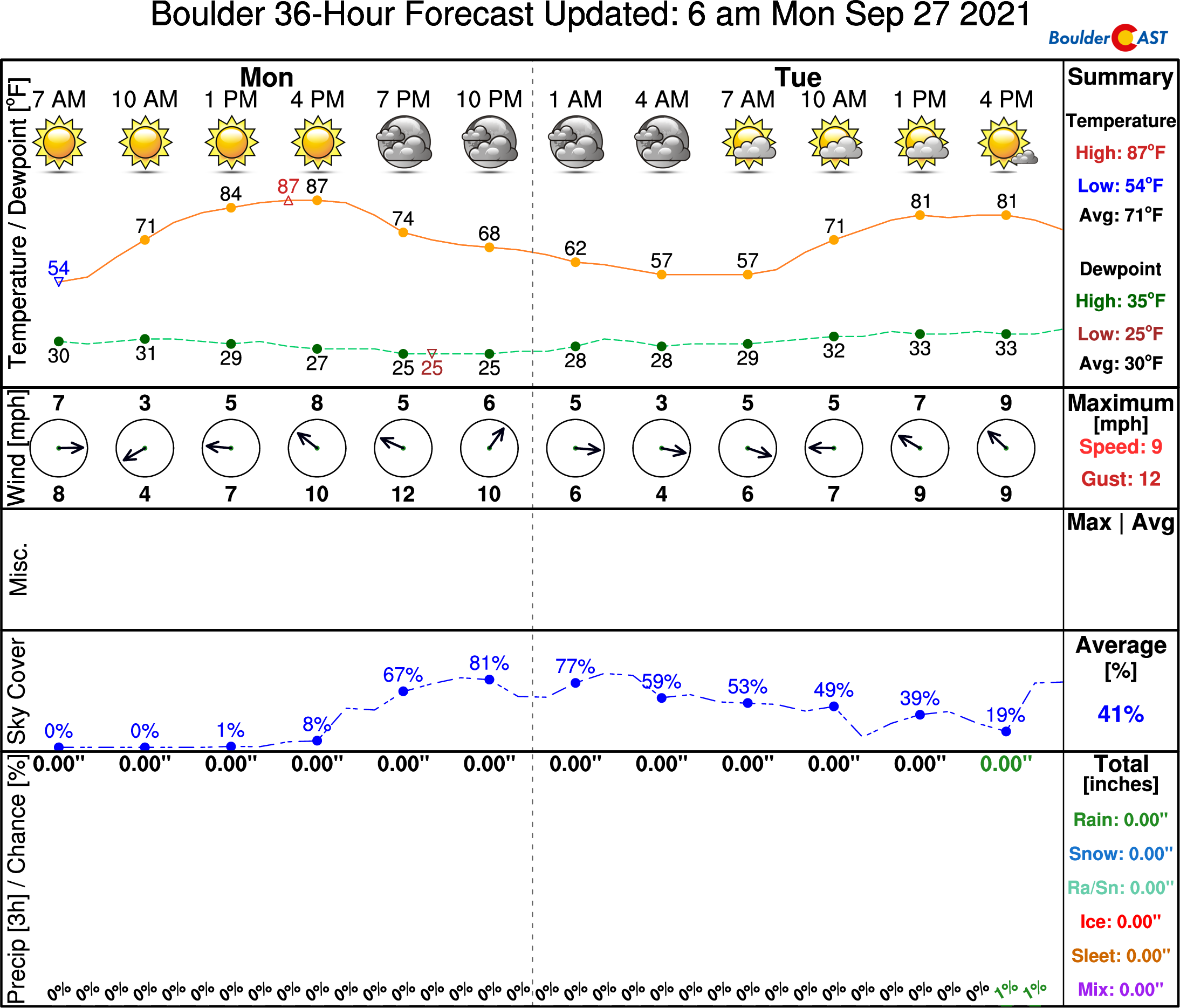
It will be fairly quiet Monday with highs in the upper 80s in most locales. Unlike Sunday, we’re not expecting a record high in Boulder Monday as the existing record is 92°F…a little to far to reach this afternoon.
Over the last 125 years, #Boulder had never reached 90°F on September 26th. That changed yesterday…🔥#COwx #RecordHeat pic.twitter.com/gIak3eUHie
— BoulderCAST Weather (@BoulderCAST) September 27, 2021
Here’s a look at the weather in Boulder through Tuesday evening (from our NowCAST product).
Clouds will increase later today and tonight as the low pressure system tracks northward. By Tuesday (below), that area of low pressure moves into central Colorado, along with the trough axis sliding into Nevada. At the same time, a ridge of high pressure will set up over the Midwest into Missouri and Iowa. This high pressure will prevent the trough over us from moving out — thus we’ll likely get stuck under this unsettled pattern through much of the week ahead thanks to this blocking high pressure. Only lower 80s are forecast Tuesday with abundant cloud cover and spotty rain chances, though most of the action will be in the higher terrain.
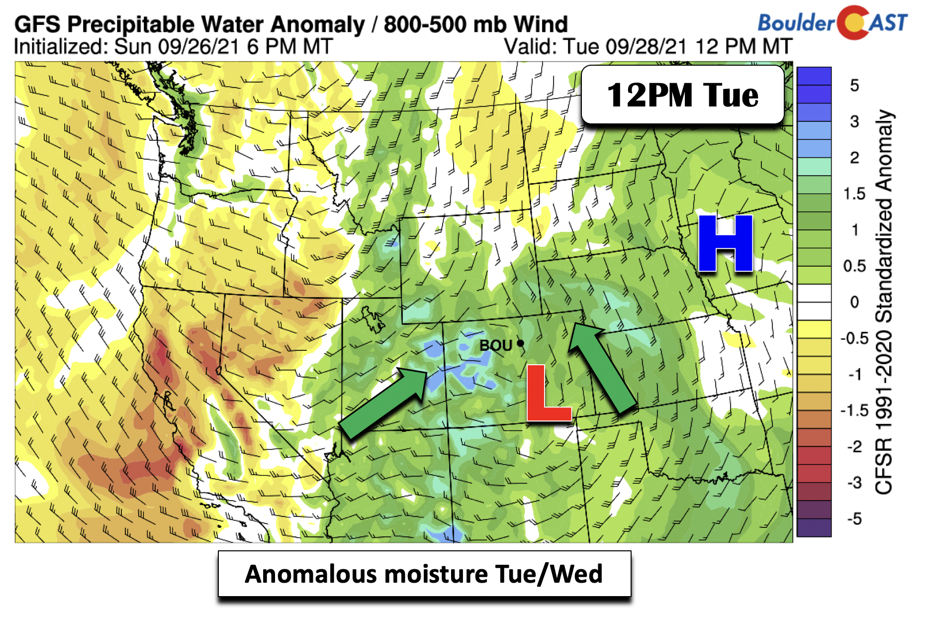
Anomalous moisture streams north as the low pressure moves into central Colorado (below). However, additional moisture also builds in from the west from the approaching trough axis. Thus, there is plenty of “juice” to work with from the two systems.
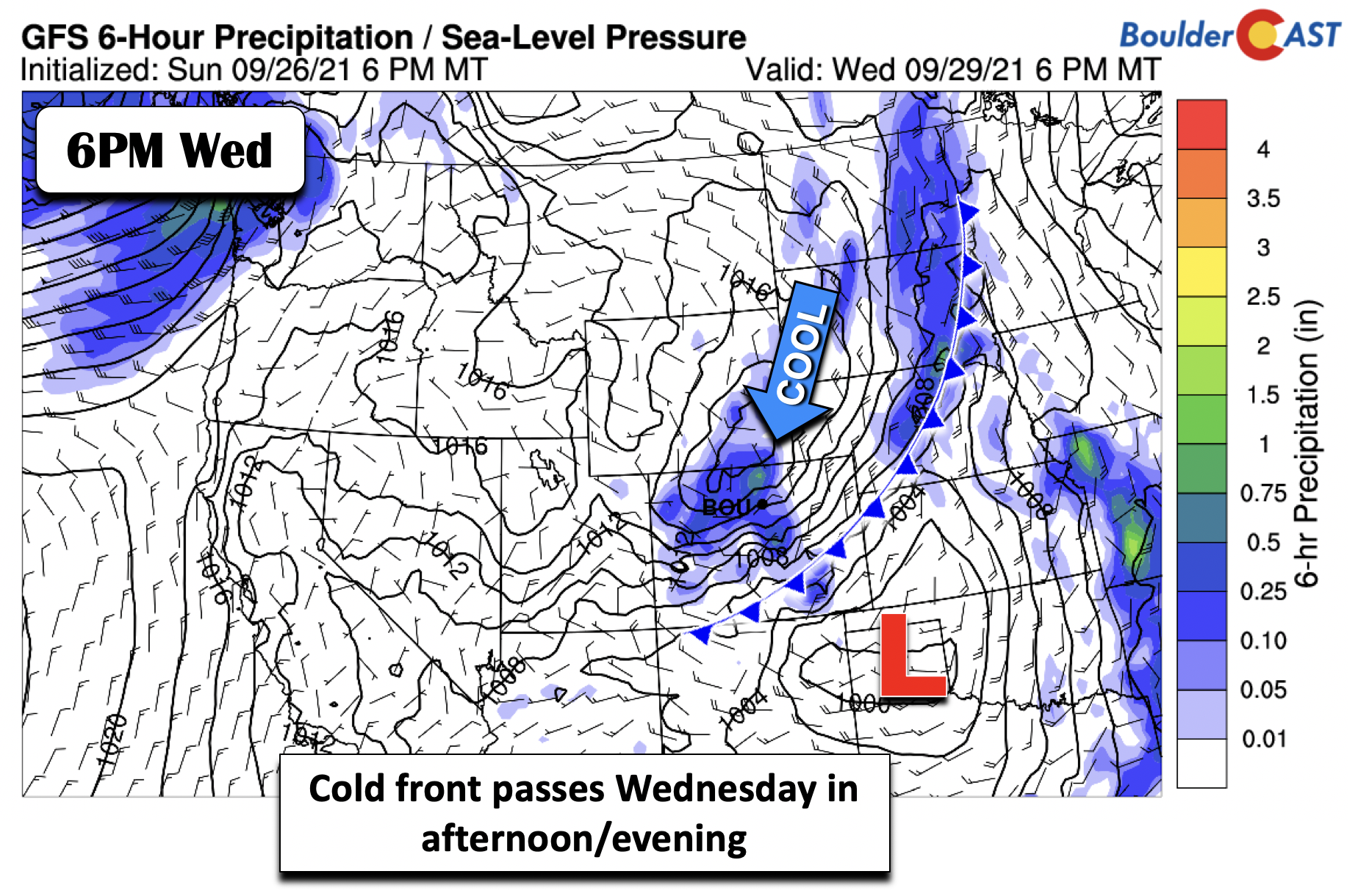
We think the best chance of rainfall will be late Tuesday through Wednesday evening. At this time, it appears that the trough will force a cold frontal passage sometime between late Tuesday night to Wednesday evening – the timing is still up for debate but will likely trend faster as this tends to be the case. Overall, the bottom falls out in terms of temperatures on Wednesday, with highs only in the 60’s under clouds and the cooler airmass. As for precipitation, upslope should generate a band of rain Wednesday across the Foothills and Plains. Yes, ’tis the season for upslope precipitation once again!
There will likely be a wave of wildfire smoke from California as the Pacific cold front blows across Colorado. The timing on this is not certain right now as it is difficult to predict smoke dispersion several days in advance. However, it looks like a bulk of the smoke will be arrive to our area on Wednesday.
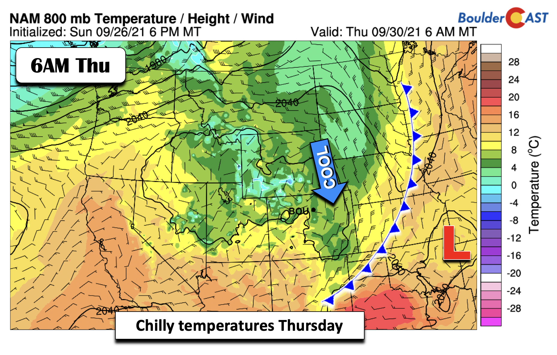
The cold front continues to move south by Thursday, reaching all the way into northern Texas and southern New Mexico. Highs will most likely be at or a few degrees cooler on Thursday relative to Wednesday in the low to middle 60’s. There’s also a chance we get stuck in the 50’s. While rain showers are possible Thursday and Friday, most of the lift is expected to move out so that only slight chances are warranted. However, with a cut-off low involved, uncertainty is a big higher than usual.
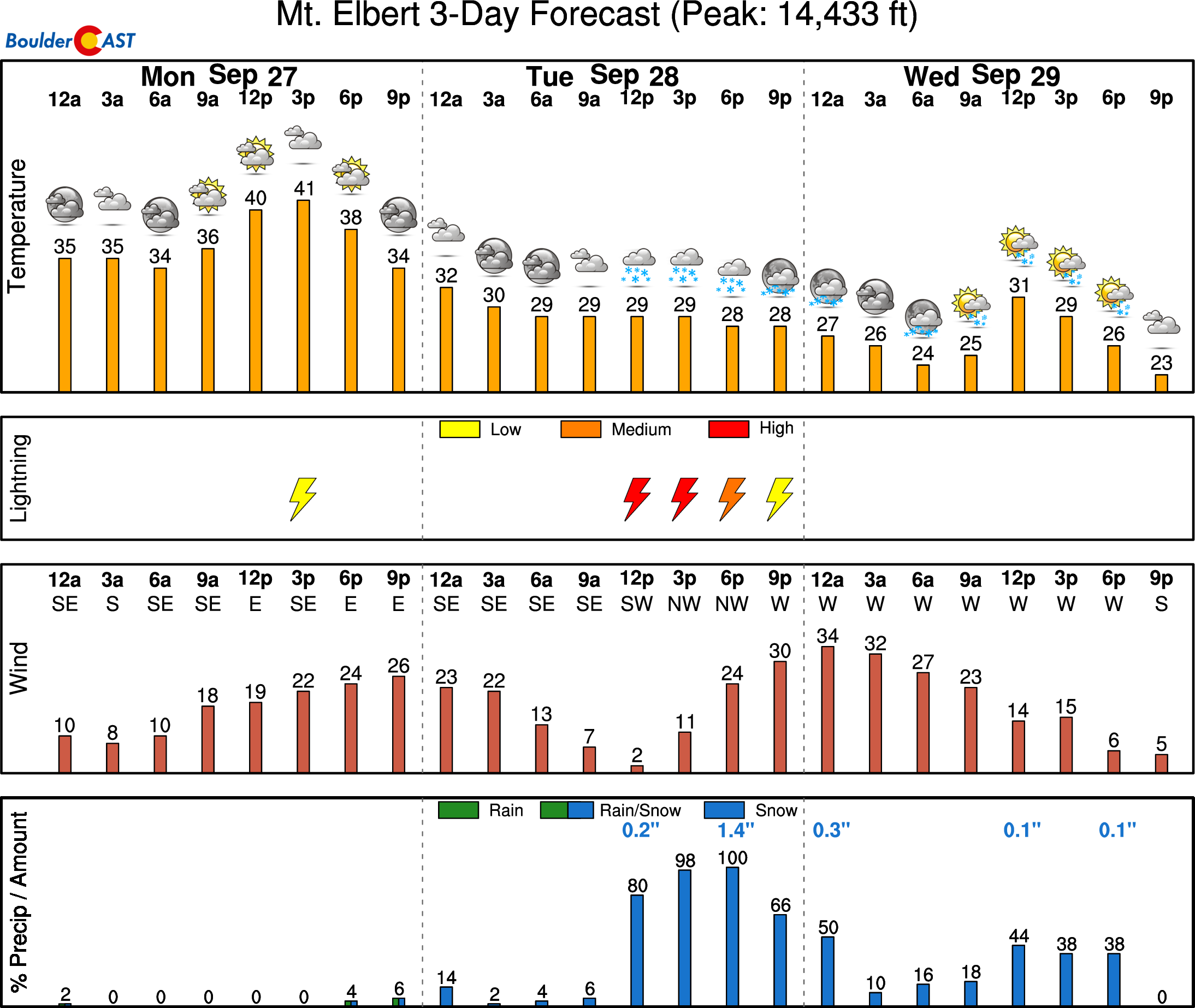
Weather this week will be cold enough for some of the precipitation in the Mountains to fall in the form of snow…which by the way it not at all uncommon this time of year. The cooler air and precipitation will overlap late Tuesday night into Wednesday night with 1 to 4″ of new snow possible above 10,000 feet. We may see snow levels come down even further (close to 8000 feet perhaps), but accumulation under 10,000 feet should be less than 1″.
It’s also important to note that while cold, there will be plenty of clouds around this week to prevent the chance of frost across the Denver and Boulder areas. We shouldn’t see temperatures at night drop much below 40 degrees, if that.
Drying out with a slow trend to seasonal weather by the weekend
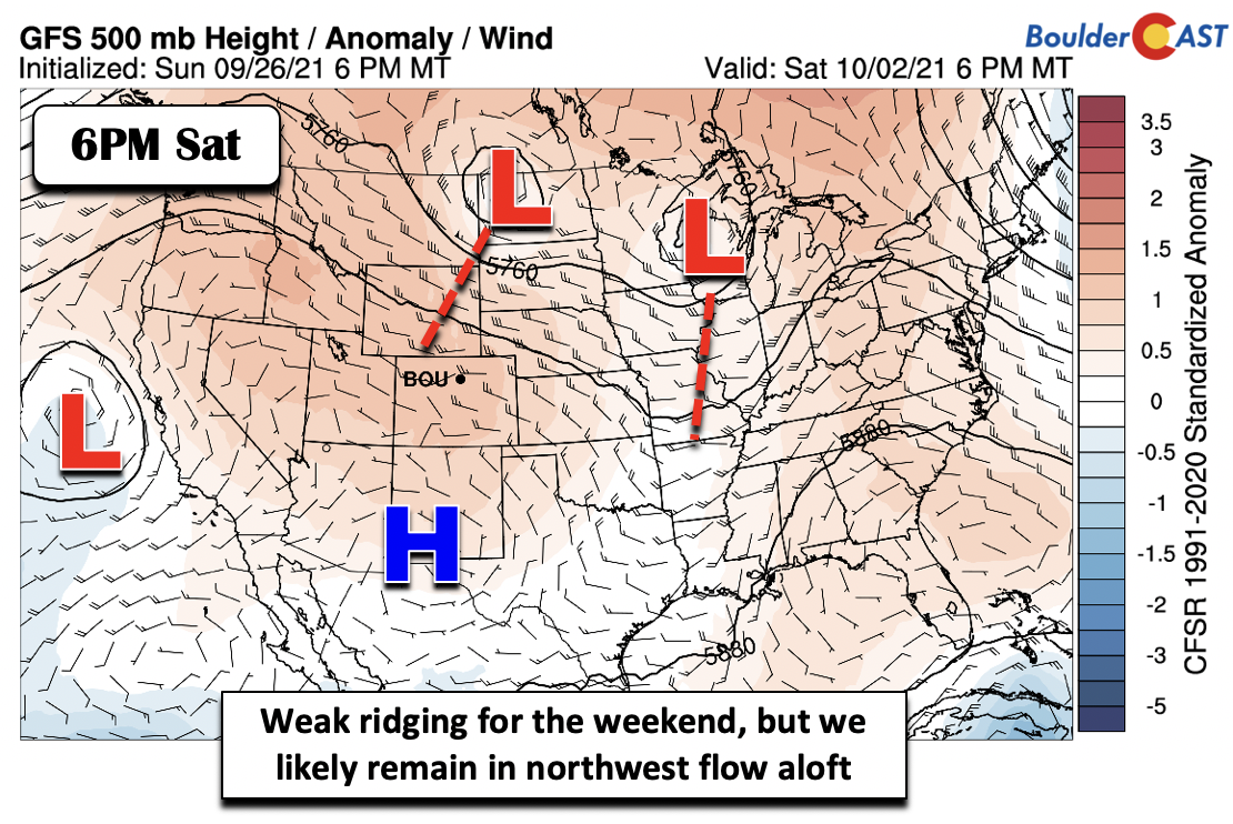
Come Friday, the slew of model guidance indicates that the trough over us will gradually weaken. The ridge in the Midwest also dies out, allowing weak ridging to take over for us. However, west-northwest flow aloft will likely remain over the state into the weekend (below). As a result, any truly warm temperatures will be slow to return with a series of backdoor cold fronts that could move in from the north. In addition, there could be a hit or miss chance of some showers, but the overall trend should be drier. Temperatures also slowly trend back up closer to average into the low to middle 70s from Friday through Sunday.
Overall, not a terrible week ahead. It’s certainly a shift towards more appropriate weather for late September, and at least things look to mostly dry out for a pleasant weekend ahead.
Stay up to date with Colorado weather and get notified of our latest forecasts and storm updates:
We respect your privacy. You can unsubscribe at any time.
Forecast Specifics:
Monday: Lots of sunshine early but increasing clouds late in the day. Highs in the upper 80’s on the Plains and upper 70’s in the Foothills.
Tuesday: Mostly cloudy with a slight chance of thunderstorms in the afternoon/evening, mainly across the higher terrain. Temperatures in the low 80’s on the Plains and upper 60’s in the Foothills.
Wednesday: Rain showers likely under overcast skies, particularly in the afternoon and evening. Highs much cooler in the middle 60’s on the Plains and middle 50’s in the Foothills.
Thursday: A slight chance of showers, but otherwise mostly cloudy and chilly with highs in the lower 60’s on the Plains and lower 50’s in the Foothills.
Friday: More sun than clouds and likely dry. Maximum temperatures around 70 on the Plains and upper 50’s in the Foothills.
Mountains: Wet weather is forecast from today through Wednesday, along with cloud cover, gusty winds at times, and some high mountain snow (up to 4″ above 10,000 feet in the northern Mountains). Drier weather returns late in the week. Check our SummitCAST page for up-to-date forecasts for more than 120 mountain destinations across Colorado, including all the 14ers.
Help support our team of Front Range weather bloggers by joining BoulderCAST Premium. We talk Boulder and Denver weather every single day. Sign up now to get access to our daily forecast discussions each morning, complete six-day skiing and hiking forecasts powered by machine learning, first-class access to all our Colorado-centric high-resolution weather graphics, bonus storm updates and much more! Or not, we just appreciate your readership!
.
Spread the word, share the BoulderCAST forecast!
.







You must be logged in to post a comment.