The week starts out breezy and chilly, but warms up the next few days before a snow event comes together late Wednesday into Thursday. We give our early thoughts on the snow chance and discuss the pleasant end to the week thereafter.
Breezy and chilly to start
Yesterday was quite the windy day with leaves blowing everywhere! BoulderCAST Station showed consistent wind gusts in the 25 to 35 mph range straight out of the west-northwest (below). This was thanks to a tight pressure gradient across the area from a storm system in the upper Midwest.
As for today, the upper-level low pressure has drifted further to our east into eastern South Dakota. However, it is quite the wound-up system, so much so that it will continue to influence the Front Range for one more day. The jet stream (below) remains oriented northwest to southeast over the western part of the state. The moderate pressure gradient and upper-level winds will make for another breezy day, with wind speeds from 10 to 20 MPH with gusts at times to 30 MPH. Highs will be warmer by a tad only in the low to maybe middle 50’s under a mix of wave clouds and sunshine.
While west-northwest winds and downslope will be keeping the Metro area dry, the Mountains will see another round of fresh snow (below). The northwest facing slopes, such as Steamboat, will be prime winners in this setup, picking up another 3 to 8″ when all is said and done by Tuesday morning. Take caution if heading into the Mountains today as Winter Weather Advisories are posted with travel likely impacts anywhere near or above 10,000 feet.
Warmer before a chance of snow
On Tuesday, the pressure gradient relaxes as the trough further exits eastward into the Great Lakes. Behind it, weak ridging builds in from the west (below). That will aid in a nice downslope warm-up, with highs likely rebounding into the low to middle 60’s with lots of sunshine. The winter system slated to move into our area on Wednesday will be just forming at this time in Washington.
Decent snow chance Wednesday night
By Wednesday, we start to see a more active weather pattern! A series of low pressure shortwaves are expected to drop down in the cold northwest flow and make their way into northeast Colorado late Wednesday and early Thursday. Currently, there are differences in terms of the timing and location, as usual, with the NAM slightly faster and the GFS slower. That leads to some uncertainty in the high temperature forecast, anywhere from low to middle 50’s in the faster solutions, to the lower 60’s in the slower ones. Nevertheless, the two models paint a wintry scenario of upslope snow across Denver and Boulder during this period. Expect a “quick hit” of upslope snow, with possible jet enhancement and plenty of cold air.
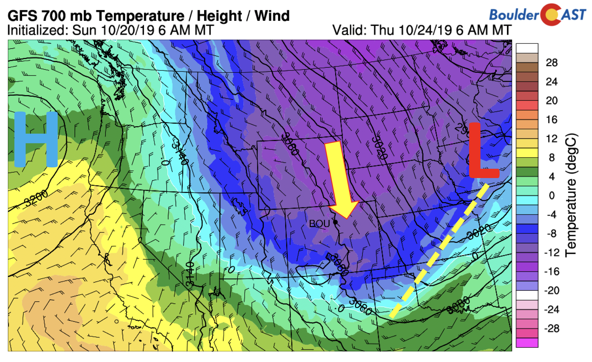
The cold air at 700 mb approaches -14 degrees Celsius aloft by Thursday morning (see below). It will thus be a cold Thursday with highs only topping out in the 30’s to lower 40’s with that chance of snow in the morning and skies slowly clearing as the day progresses.
These approaching storm system has a few things that are favorable for snow:
- Cold air
- Decent upslope in the low to mid-levels of the atmosphere
- Some weak but possible jet forcing
- Slightly elevated moisture
- Overnight timing
Some cons to the system include:
- Fast moving, a “quick hit” of snow (~12 to 15 hours)
- Uncertainty in timing and location of maximum lift
The long-term snow totals from the models show light to moderate-impact snow accumulations possible over the Denver Metro area (1-3″ NAM, 2-6″ GFS, 4-9″ Euro).
All in all, it’s not worth going into too much detail at the moment given the uncertainty, but we will be watching this storm for anticipated wintry impacts Wednesday night! Check back later in the week for updates.
The week ends with a return to warmer weather, likely in the 50’s to maybe lower 60’s depending on the strength of the ridge poised to move in from the west on Friday.
Forecast Specifics:
Monday: A mixture of clouds and sunshine. Breezy with west-northwest winds at 10-20 MPHand some gusts to 30 MPH. Highs in the low to middle 50’s on the Plains and lower 40’s in the Foothills.
Tuesday: Mostly sunny and warmer with highs in the low to middle 60’s on the Plains and lower 50’s in the Foothills.
Wednesday: Partly cloudy skies to start, then increasing clouds through the afternoon with a chance of rain changing to snow in the late evening. Several inches of accumulation are possible. Highs in the middle 50’s on the Plains and middle 40’s over the Foothills.
Thursday: Mostly cloudy and cold with a chance of snow early in the morning, then clearing skies through the day. Highs only in the lower 40’s for the Plains and middle 30’s in the Foothills.
Friday: Sunny and warmer with highs in the near 60 degrees on the Plains and upper 40’s in the Foothills.
High Country: Breezy and snowy conditions will persist Monday across the mountains, particularly over the northwest facing slopes of northern and northwest Colorado. Snow totals will be in the 4 to 8 inch range. Warmer and calmer conditions take over Tuesday before snow returns yet again Wednesday night and Thursday. A more tranquil period begins Friday and continues through the upcoming weekend. Check our PowderCAST page for always-updated weather forecasts for all of Colorado ski resorts.
DISCLAIMER: This weekly outlook forecast is created Monday morning and covers the entire upcoming week. Accuracy will decrease as the week progresses as this post is NOT updated. To receive daily updated forecasts from our team, subscribe to BoulderCAST Premium.
.
Spread the word, share the BoulderCAST forecast!


You must be logged in to post a comment.