This week will feature a figurative roller-coaster ride in temperatures across Colorado. This is thanks to the first fall-like storm system of the year scooting across the northern United States. It will be predominately dry for us, but rain chances do return late in the week.
DISCLAIMER: This weekly outlook forecast was created Monday morning and covers the entire upcoming week. Accuracy will decrease as the week progresses as this post is NOT updated. To receive daily updated forecasts from our team, subscribe to BoulderCAST Premium.
E
arly in the week, our weather will be dominated by a large trough of low pressure that is currently diving south out of Canada. This trough pushed a cold front through the Denver Metro area before sunrise this morning. This is welcomed news, especially considering that Boulder has set new record high temperatures three times in the last week alone!
The pattern is shown below at the 250 mb level for today (left) and tomorrow (right). Today the trough is over Montana and North Dakota. A jet streak is positioned from western Montana into northern Colorado. It will be blustery in the High Country these next few days! The trough sinks south and east by tomorrow and moves into Minnesota. This weather pattern will keep us in that cooler northeasterly upslope flow this afternoon and tomorrow as well.
As mentioned, the first cold front associated with the trough already passed through this morning. A second front will arrive for Tuesday. These fronts are quite noticeable in the low-level temperature fields (below). The blue line denotes the frontal boundary. In both instances, cooler air settles into northeast Colorado from Wyoming and Nebraska.
Despite autumn still being four weeks out, this trough is certainly the first fall-like system to impact the United States. However, the coldest air will remain in the Dakotas and Minnesota. This pattern will keep highs feeling very comfortable these first few days of the week in the upper 70’s to lower 80’s for our region. This new airmass will also set the stage for a very dry week under lots of sunny skies!
Transitioning into Wednesday through Friday, the trough exits and moves from the Great Lakes (left) into eastern Canada (right). The ridge of high pressure, which earlier this week was well suppressed to our south, will make its way back and allow warmer air to spread into the region Wednesday and Thursday. 90+ degree temperatures will quickly regain control across the area. By Friday, however (right), increased moisture from a shortwave may combine with another weak cold front to increase clouds and produce a threat of storms in the afternoon/evening hours.
The bottom left figure shows the predicted frontal position on Friday, banked up along the Foothills as usual. This time around, with the added moisture content, instability is expected to be larger (bottom right). This combined with shear will lead to our best chance of storm activity this week.
Right now being four days out, at best we’d say a 30% chance of rain, but a fine-tune of the forecast could go up or down….time will tell. In addition the chance of rain, temperatures should cool off following the frontal passage on Friday. The ensembles show considerable variation, with highs on Friday in Denver possibly ranging from the mid 60’s to the mid 80’s. Regardless of what transpires, the week will likely end where we started…on the cooler side!
Forecast Specifics:
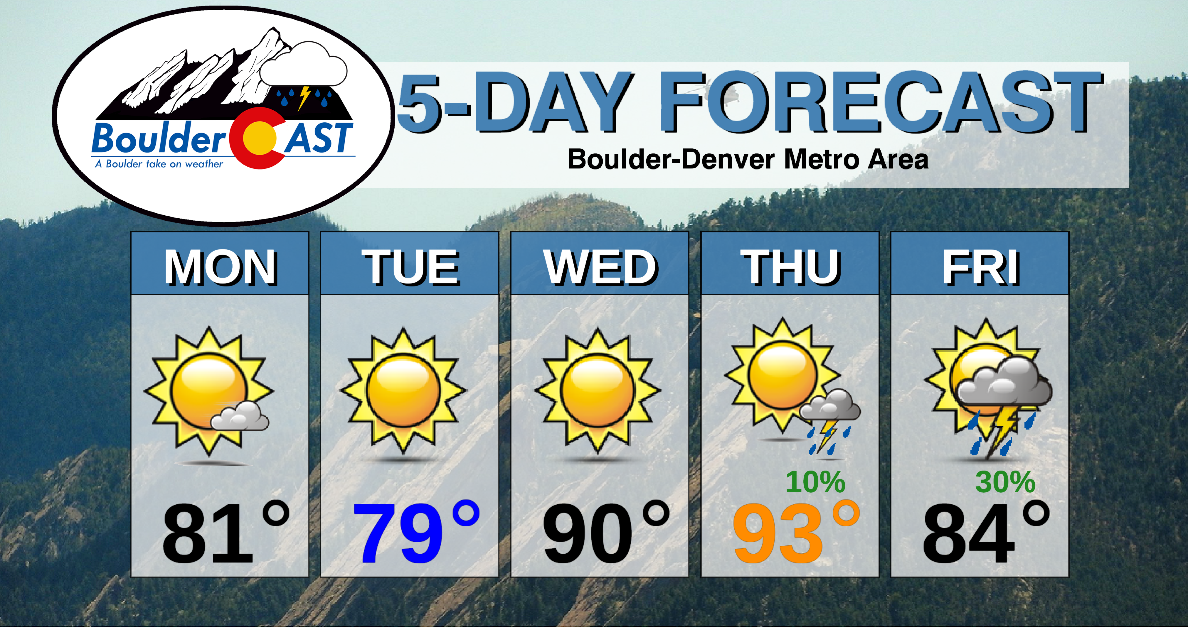
Monday: Mostly sunny, dry, and noticeably cooler. Highs in the lower 80’s on the Plains and lower 70’s in the Foothills.
Tuesday: Sunny and continued cool with temperatures in the upper 70’s for the Plains and middle 60’s for the Foothills.
Wednesday: Sunny skies and warmer with highs in the upper 80’s on the Plains and middle 70’s for the Foothills.
Thursday: Increasing clouds and hot with isolated late day thunderstorms. High temperatures in the lower to middle 90’s on the Plains and near 80 in the Foothills.
Friday: Sunny skies giving way to mostly cloudy conditions with a 30% chance of showers and storms. Cooler with highs in the low to middle 80’s on the Plains and lower 70’s in the Foothills.
High Country: Very dry air across the state will lead no chance of storms through Wednesday but it will be blustery in the Mountains with the jet stream overhead during this time. Widely scattered storms return to the forecast Thursday and especially Friday thanks to a shortwave system and added moisture content. Visit our SummitCAST page for updated forecasts for more than 120 Colorado mountain destinations, including all of our state’s majestic 14ers.
.
Spread the word, share our forecast!
.


You must be logged in to post a comment.