Our Memorial Day week starts off dry and pleasant for the holiday with no chance of rain on Monday and sunny skies. However, we’ll see daytime chances of isolated/scattered storms across the Front Range each day from Tuesday onward, including some severe storms mixed in at times. Rainfall chances may be highest later in the week as a cold front slowly tries to approach from the north and west. This front will also cool us off by late-week. Let’s take a look!
This week’s highlights include:
- A pleasant Memorial Day: A picture-perfect holiday is expected Monday with upper 70s to near 80 for the BolderBoulder and Memorial Day celebrations
- Daily isolated/scattered storms: Storms will be in the forecast Tuesday onward as a series of weak disturbances and moisture track in with southwest flow aloft
- Temperatures: Warm temperatures are expected this week pushing into the mid to upper 80s by Wednesday, but falling back into the upper 70s by Friday
DISCLAIMER: This weekly outlook forecast is created Monday morning and covers the entire upcoming week. Accuracy will decrease as the week progresses as this post is NOT updated. To receive daily updated forecasts from our team, among many other perks, subscribe to BoulderCAST Premium.

Go Premium, get all the perks.
Daily Forecast Updates
Get our daily forecast discussion every morning delivered to your inbox.
All Our Model Data
Access to all our Colorado-centric high-resolution weather model graphics. Seriously — every one!
Ski & Hiking Forecasts
6-day forecasts for all the Colorado ski resorts, plus more than 120 hiking trails, including every 14er.
Smoke Forecasts
Wildfire smoke concentration predictions up to 72 hours into the future.
Exclusive Content
Weekend outlooks every Thursday, bonus storm updates, historical data and much more!
No Advertisements
Enjoy ad-free viewing on the entire site.
A Dry Memorial Day but storm chances will exist Tuesday onward
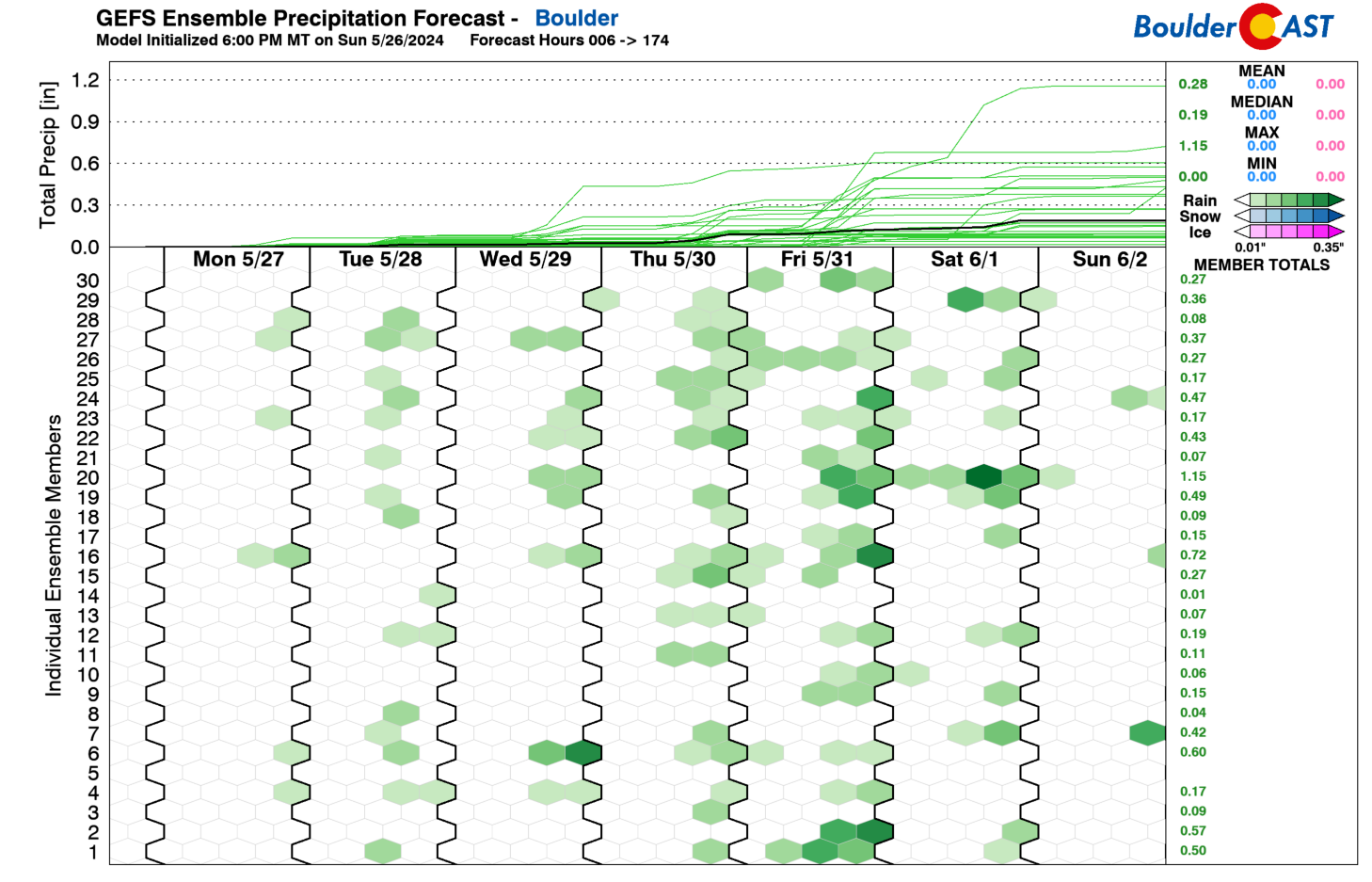
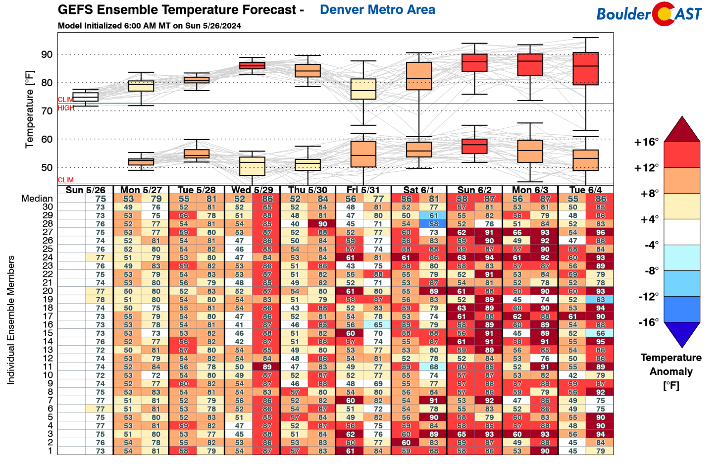
We begin the week with dry and pleasant weather for the Memorial Day holiday. However, as you can see below in the GEFS precipitation plume, you’ll notice that precipitation chances exist nearly every day from Tuesday through Saturday. We’ll discuss the reason for this shortly, but for now expect typical daytime storm chances after Monday’s holiday.
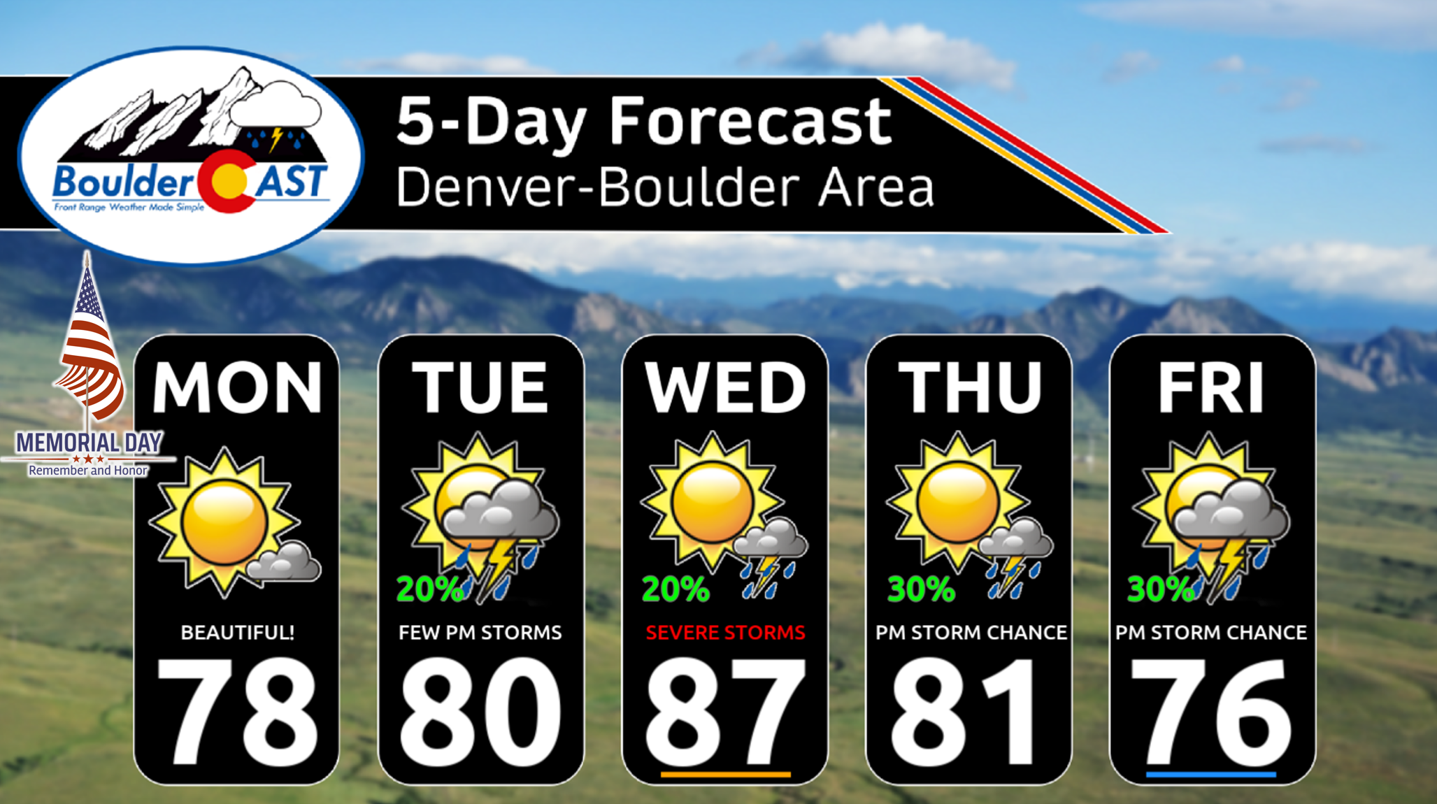
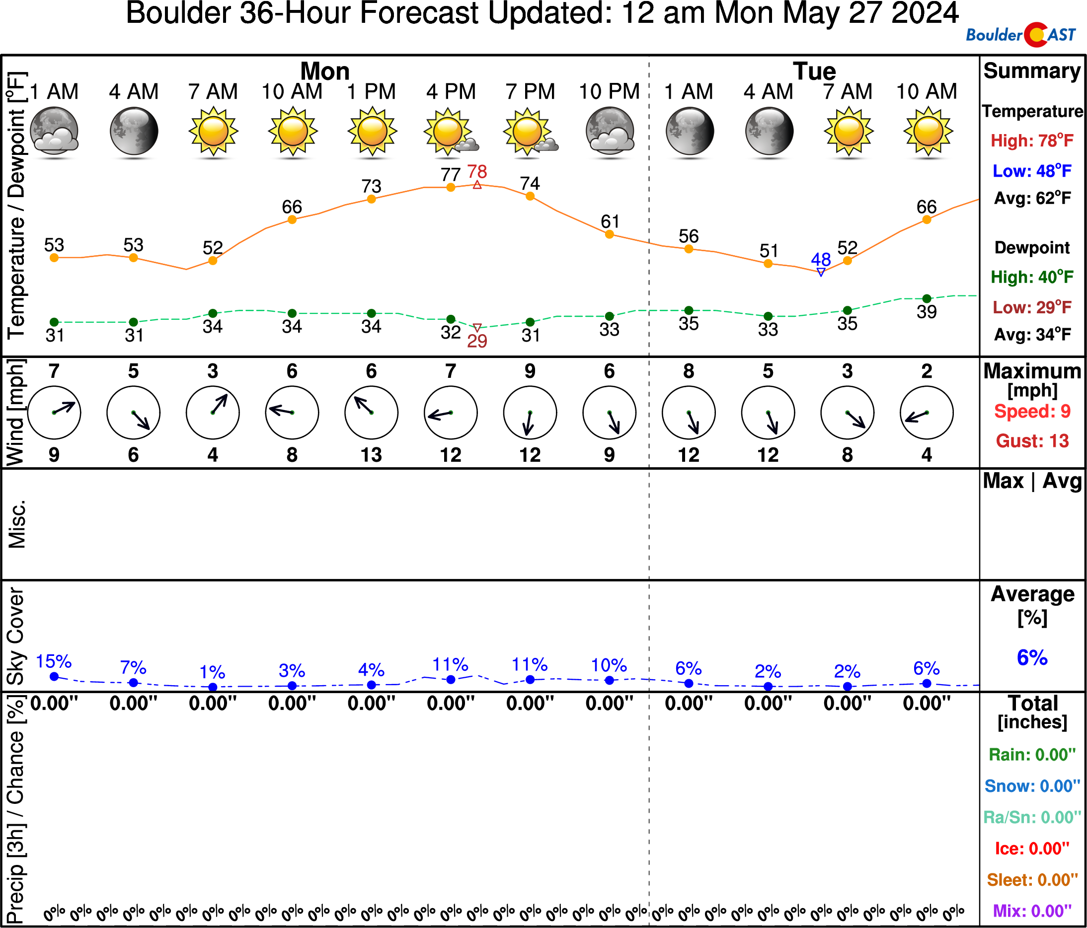
Our Memorial day will be picture perfect with sunny skies and highs ranging from the upper 70s to around 80 degrees. It will be perfect weather for the Boulder Bolder and other Memorial Day celebrations, including BBQs and pool grand openings! High pressure ridging on Monday will result in dry conditions with just a few spotty late-day clouds around to interrupt the sapphire skies.
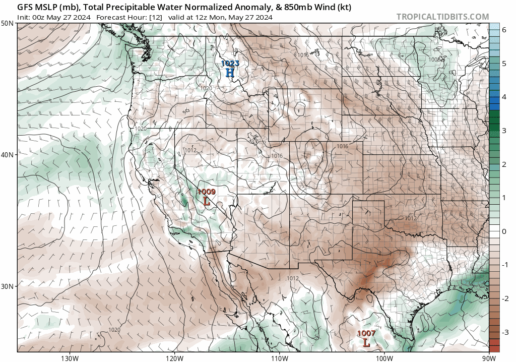
The animation below shows the trend in ridging over us Monday towards a more favorable pattern for moisture and precipitation. Starting Tuesday, and largely continuing through the remainder of the week and weekend, we will start to see influence from the southwest as a trough remains in place from the Pacific Northwest. That trough to our northwest will feed Colorado with increasing amounts of moisture from the Pacific.
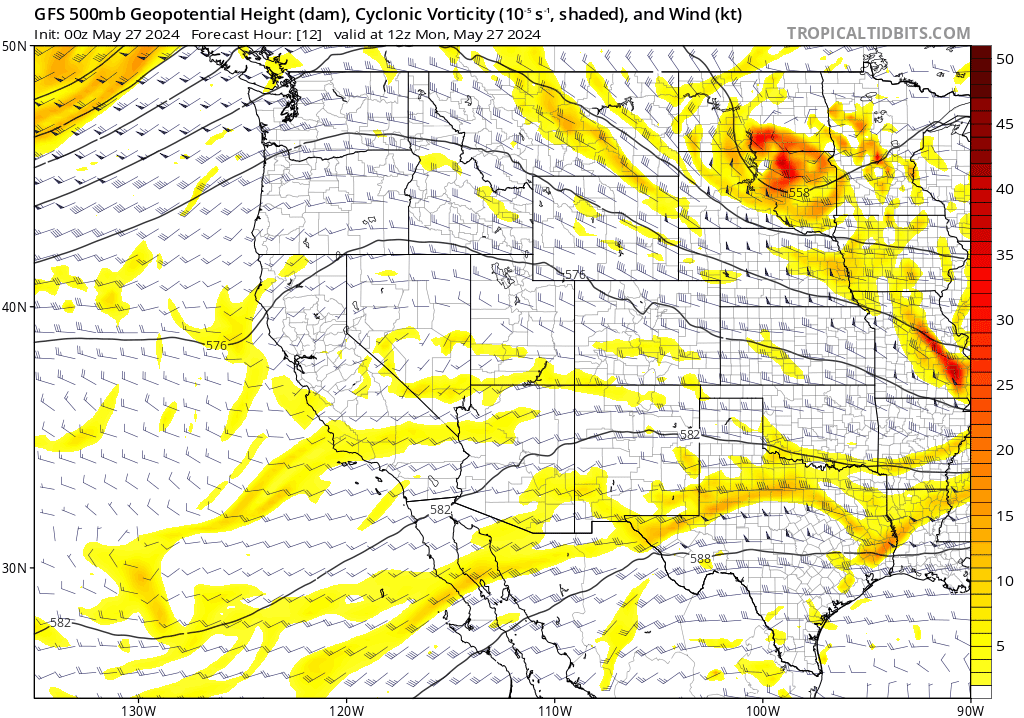
As that moisture continues to funnel into the region, it will favor isolated to scattered afternoon to early evening storms over the Front Range Tuesday through Friday. Right now, it is difficult to pinpoint which days have the highest chances, although Thursday into Saturday could favor more widespread precipitation as a slow moving front sags south from Wyoming and Montana.
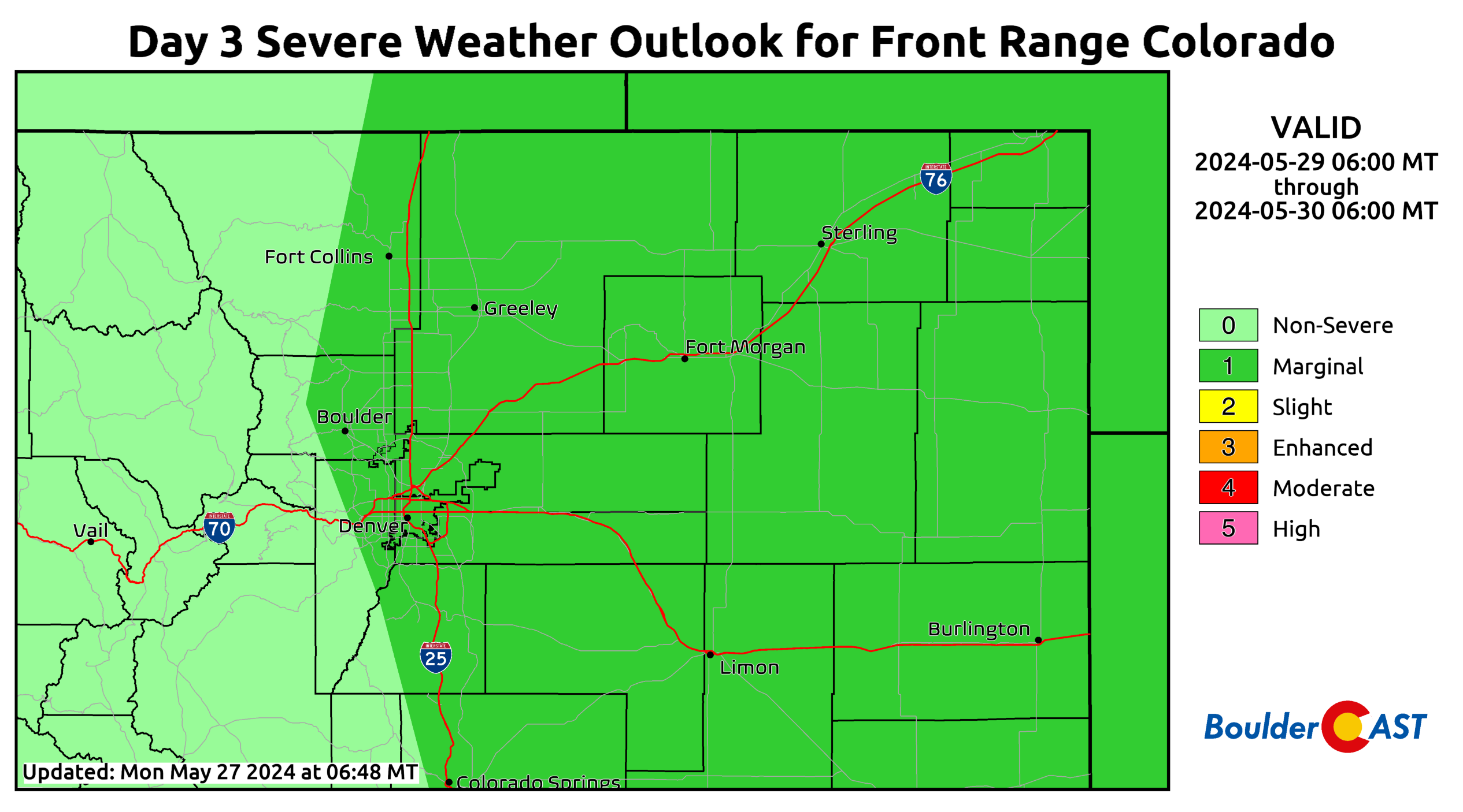
Each day certainly won’t be a wash out, but we’ll at least see a 10-30% chance of storms every day after Monday, which could increase to 40% or higher by late-week. Wednesday and Thursday will also come with a risk of isolated severe storms (large hail, tornadoes). The Day 3 (Wednesday) severe outlook from the Storm Prediction Center (below) paints almost all of eastern Colorado at Marginal Risk for now, including Boulder and Denver. We expect to see the greatest risks for severe storms well east of Denver where moisture/instability will be most significant, as usual.
Temperatures will increase well into the 80s by mid to late-week, but watch for a trend downward Friday into Saturday. That late-week cool down will be related to the higher chances of showers and storms.
Have a wonderful holiday and week!
Get BoulderCAST updates delivered to your inbox:
Forecast Specifics:
Monday: Sunny and pleasant temperatures topping out near 80 degrees over the Denver Metro area with upper 60s in the Foothills.
Tuesday: Partly cloudy with a 20% chance of afternoon/evening storms and highs in the lower 80s on the Plains and near 70 degrees in the Foothills.
Wednesday and Thursday: Partly cloudy with a 20-30% chance of afternoon/evening storms, some of which will turn severe (especially east of Denver Wednesday, and SE of Denver Thursday). Highs in the 80s for the Plains and 70s in the Foothills.
Friday: A 30-40% chance of showers and storms with highs in the middle 70s for the Plains and middle 60s in the Foothills.
Weekend: The pattern stays somewhat active with continued chances of showers/storms, especially on Saturday and highs in the 70s for the Plains and 60s in the Foothills.
DISCLAIMER: This weekly outlook forecast is created Monday morning and covers the entire upcoming week. Accuracy will decrease as the week progresses as this post is NOT updated. To receive daily updated forecasts from our team, among many other perks, subscribe to BoulderCAST Premium.
Go Premium, get all the perks.
Daily Forecast Updates
Get our daily forecast discussion every morning delivered to your inbox.
All Our Model Data
Access to all our Colorado-centric high-resolution weather model graphics. Seriously — every one!
Ski & Hiking Forecasts
6-day forecasts for all the Colorado ski resorts, plus more than 120 hiking trails, including every 14er.
Smoke Forecasts
Wildfire smoke concentration predictions up to 72 hours into the future.
Exclusive Content
Weekend outlooks every Thursday, bonus storm updates, historical data and much more!
No Advertisements
Enjoy ad-free viewing on the entire site.
Enjoy our content? Give it a share!


You must be logged in to post a comment.