
The week ahead will be drier compared to recent times, but we won’t necessarily call it dry. Storm chances, though meager, will exist from Tuesday onwards, with our best shot at rain in the latter part of the week boosted by a cold front. A more unsettled pattern with increasing chances of storms will arrive for the weekend.
This week’s highlights include:
- The atmosphere dries out under large-scale southwest flow
- Temperatures will be generally above average, but wavering between the 70’s and lower 80’s
- Small chances of storms Tuesday through Friday, with potential severe weather towards the latter part of the week
- Another troughy pattern for the weekend could bump up storm chances again

DISCLAIMER: This weekly outlook forecast is created Monday morning and covers the entire upcoming week. Accuracy will decrease as the week progresses as this post is NOT updated. To receive daily updated forecasts from our team, subscribe to BoulderCAST Premium.

Severe weather over the weekend
It was an active weekend across eastern Colorado with Tornado Watches issued on both Saturday and Sunday. Most of the action was east of the Denver Metro area where the atmosphere was primed with more moisture and warmer temperatures. Numerous tornadoes, large hail and damaging wind gusts were observed across the eastern Plains. The storm reports from over the weekend are shown below. While it was quieter in our neck of the woods, a few storms did develop, mainly Saturday and Saturday night, producing a widespread 0.25 to 0.75″ of rainfall for most areas.

Drier weather for a change starts our week
What has been a wet pattern in recent times will finally dry out to start the week. The mid-level low pressure system that was off to our west and bringing in plentiful moisture has moved up into Canada, as seen in this morning’s water vapor satellite image. The moisture plume is well east of us, now over the Great Plains and Midwest. Drier air (yellow shading) has worked into the state and will largely be that way through Tuesday.

A weak surface cold front is currently situated from the Dakotas, through eastern Colorado and into New Mexico (below left) for today. Drier dewpoints are present west of the boundary, with juicy dewpoints well out east in Kansas. Lots of sunshine is expected Monday with temperatures in the middle 70’s.

The Pacific storm track remains active, however. On Tuesday, another low pressure moves onshore (below left) into Oregon during the afternoon and evening. It will remain west of us through the day, though a small ripple of energy will stream out ahead of it in the evening hours into early Wednesday. The GFS is the only model that has a very meager chance of a shower or storm in the evening with some weak instability (below right) building back into Colorado. Forcing for ascent is weak at best. We’d expect a 5% chance or less of a shower late Tuesday into the night with highs warming into the upper 70’s.

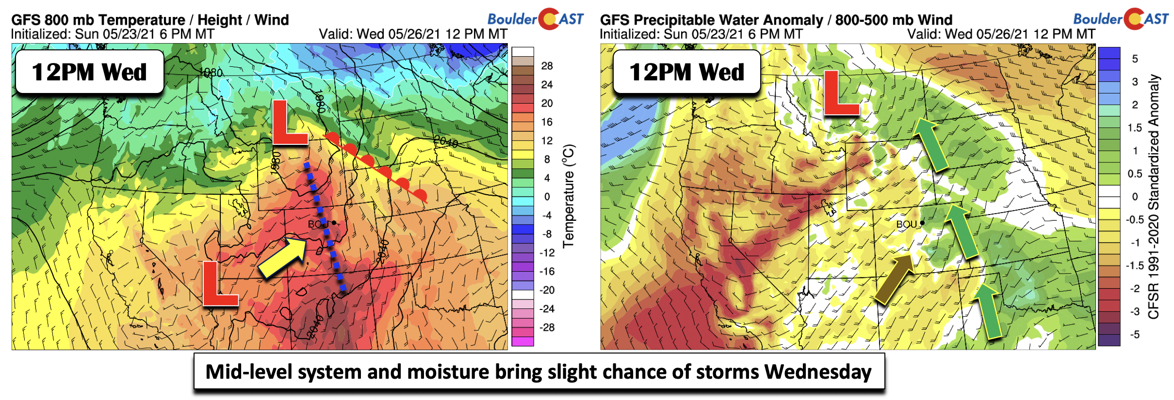
Small chances of storms toward latter part of the week
For Wednesday onward, a more active flow with the aforementioned mid-level trough will favor slight chances of storms each day through Friday. Wednesday’s pattern should feature a surface low pressure over northwest Wyoming, with a warm front lifting north into Nebraska (below left). The warm front should get us into the lower 80’s. Some moisture return is evident in the precipitable water anomalies (below right) with the mid-level circulation over Montana. A 20% chance of storms will exist Wednesday afternoon/evening (under increasing clouds) with some shortwave energy tied to the system to our north and increasing instability. However, given that we will largely be under downslope flow, most activity should reside east of I-25.
By Thursday, although the details are not pinned down, the low pressure in Wyoming will bring a cold front through the state. Upslope flow and a cooler airmass will lower highs into the middle 70’s. The mid-levels will remain active with that system just to our north. Moisture return under the easterly surface flow will favor late-day isolated storms under favorable shear profiles (below right). Confidence is low on this, but 20-30% is warranted and could be something to watch for severe potential, especially in the usual spots east of the Metro area.

Come Friday, maybe your last work day (woo!), another system builds to our north along the Canadian border. Largely southwest flow will be present over Colorado at the mid-levels, with high pressure over Texas and the western Gulf of Mexico. Although models are not overly impressive in storm chances Friday, this pattern would favor isolated storm activity given the warmer flow and lingering instability in-place. Again, chances are not high, around 10-20%, with highs back into the lower 80’s.

Pattern favors increased chance of storms over the weekend
Although we have put in a chance of storms almost every day, probably the best odds of picking up some rainfall will be come during the weekend ahead. The deterministic and ensemble guidance hint at the pattern turning more active. The Pacific flow will feature another trough of low pressure setting up shop in central California. This would open the floodgates again for moisture to return into Colorado come Saturday and Sunday. We recommend taking advantage of the drier weather this week!

Stay up to date with Colorado weather and get notified of our latest forecasts and storm updates:
We respect your privacy. You can unsubscribe at any time.
.
Forecast Specifics:
Monday: Sunny and pleasant with highs in the middle 70’s for the Plains and middle 60’s in the Foothills.
Tuesday: Mostly sunny skies with a 5% chance or less of a late-day showers. Highs in the upper 70’s to around 80 for the Plains and near 70 in the Foothills.
Wednesday: Partly to mostly cloudy skies with a 20% chance of afternoon/evening storms. Highs in the lower 80’s on the Plains and lower 70’s in the Foothills.
Thursday: Sunny skies becoming partly sunny with some late afternoon/evening widely scattered storms possible. Highs in the middle 70’s in the Denver Metro and middle 60’s in the Foothills.
Friday: Sunny with a very slight chance of late-day storms. Highs back to the low 80’s on the Plains and near 70 in the Foothills.
Mountains: Largely dry conditions will exist across the higher terrain today and Tuesday. There will exist a slight chance of storms on Wednesday. A better chance of storms will exist Thursday and Friday under increasing moisture and instability. Probably the best chance of unsettled weather will be over the upcoming weekend.
Help support our team of Front Range weather bloggers by joining BoulderCAST Premium. We talk Boulder and Denver weather every single day. Sign up now to get access to our daily forecast discussions each morning, complete six-day skiing and hiking forecasts powered by machine learning, first-class access to all our Colorado-centric high-resolution weather graphics, bonus storm updates and much more! Or not, we just appreciate your readership!
.
Spread the word, share the BoulderCAST forecast!
.


You must be logged in to post a comment.