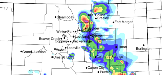
Today’s forecast calls for a rapid transition from low clouds to severe thunderstorms capable of producing large hail across the Denver Metro area. We also discuss the cooler temperatures.
Remember, these daily forecasts are Premium content. Periodically, we open this forecast up to all of our followers. Today is one of those days!
Sign up today to get the best BoulderCAST experience, including these daily forecasts every morning, complete 6-day skiing and hiking forecasts powered by machine learning, access of all our Front Range specific weather models, additional storm updates and much more!
Today only, save 25% with promo code HAIL.
Gust front last night
A pronounced outflow boundary, also known as a gust front, rushed into the Denver Metro area last night around 5:30 PM producing brief gusty winds, a period of reduced visibility due to airborne dust, and the wonderful smell of the feed lots to the northeast! The temperature dropped from the middle 90’s to the lower 80’s in the blink of an eye, with dew points rising from the upper 30’s to the upper 50’s. Can you spot the outflow in the weather graphic below from BoulderCAST Station? By the way, Boulder set a new record high temperature yesterday at 98 degrees. This comes just one day after tying the record on Monday of 96 degrees.
Disagreement in the models in regards to where storms would form yesterday afternoon out across the eastern Plains led to a tough forecast on when the moisture would arrive. It turns out it came several hours early in the evening which helped spawn a few isolated thunderstorms across the region last night. A secondary push, the actual cold front, moved in after midnight last night and reinforced the low-level moisture producing a deck of low clouds. This is where we are now…
Slow-moving storms today, a few severe
For today, the stage is set for scattered to widespread thunderstorms to develop across the region. Dew points are hovering near 60 degrees this morning.
Once the skies clear later this morning, the sun will get to work heating the surface so we can realize the more than 2000 J/kg of CAPE sitting up and down the Front Range.
Mid-level steering winds are northwesterly at only 10-15 MPH, while low-level winds will remain northeasterly. It’s not much shear, but considering how much instability we have today, some storms that form over the Boulder and Denver area could produce near 1″ to 1.5″ hail. The Storm Prediction Center has our entire area at “Marginal Risk” for severe storms, also citing hail as their main concern. However, they mention an outside chance of one or two tornadoes somewhere in eastern Colorado.
Furthermore, today’s storms will also have the potential to produce heavy downpours with rainfall rates greater than 1.5″/hr. Considering the weak mid-level winds, storms could linger causing localized flooding. The burn scars in the Foothills are most at risk today, but some minor urban flooding could occur as well.
Our forecast calls for a 60% chance of rain and highs in the lower to middle 80’s. Look for storms to begin forming by early afternoon across the Foothills, spreading eastward across the lower elevations by late afternoon through the evening.
Overall, models are painting today to be a very active one for storms in our area, and I can’t find a reason to disagree. But, hey, at least the heat wave has broken!
Today only, save 25% with promo code HAIL.


You must be logged in to post a comment.