A quick look ahead to the upcoming weekend shows substantial changes to our weather behind a Pacific cold front, including the season’s first widespread mountain snowfall! Read on for our complete weekend weather briefing.
Forecasts focused on the many ski resorts of NE Colorado.
A quick look ahead to the upcoming weekend shows substantial changes to our weather behind a Pacific cold front, including the season’s first widespread mountain snowfall! Read on for our complete weekend weather briefing.

Following a weekend of unsettled and at times, stormy weather, this week will see precipitation chances gradually decrease and highs turning quite warm to end the week. However, there are hints of another active pattern for the coming weekend over Colorado. Read on for our full weekly forecast.

After an historic snow storm produced 18″ in Boulder and up to 45″ in the nearby Foothills over the weekend, our attention turns to the week ahead. Highlights include a cold and dreary first few days, with a warming trend and gorgeous weather by week’s end. In fact, highs look to return back to the 70’s by Friday. Read on for our full forecast for the upcoming week.
We’ve been tracking the storm very closely over the last week. With forecast temperatures trending down over the last several days, the threat of potentially flooding rain has morphed into the concern for a dumping of heavy, wet spring snow for everyone across the Front Range. Read on as we present our final forecast for this historic storm.
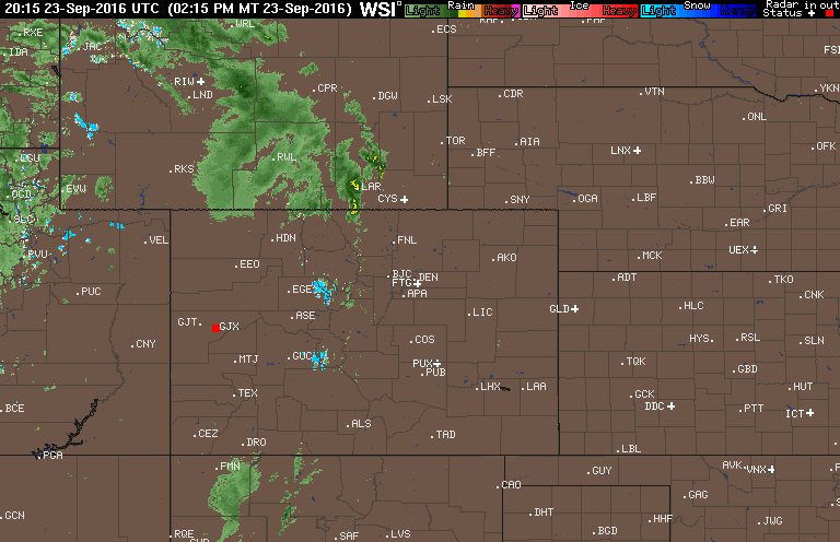
We’re currently tracking a spring storm set to arrive to eastern Colorado Sunday night. It has the potential to bring significant snowfall to parts of the area. The track has remained consistent for several days now, and the models seem to be converging on a common solution. As such, confidence is increasing and we’re here to outline what we know so far and what to expect to end the weekend.

We hope you had a wonderful weekend. Whether you were skiing up in the mountains or biking/hiking in the Foothills, the weather was perfect for all outdoor activities! The warming trend continues today, but takes a slight reprieve by midweek with a cold front ushering in mountain snow. The warmth rebounds to end the week with lots of sunshine. Overall a great week to kick of the month of April! Continue reading for our full outlook.

Great conditions for skiing will continue this week, as well as an active pattern for snow on the Plains. The focus for the week ahead will be a fast-moving system Wednesday, which will usher in below normal temperatures and little bit of white stuff. Beyond that, we’re also monitoring a second chance of snow for the weekend. Read on for our full forecast.

The March sun has already made its presence known, quickly working to wither away yesterday’s dumping of snow. We review the storm totals from across the region, and reveal when we’ll return to those spring-like 70’s (spoiler: it’s shockingly soon). We’re also already tracking our next potential snow event. Read on for details.


© 2025 Front Range Weather, LLC
You must be logged in to post a comment.