Category: BoulderCAST Daily (Page 287 of 466)

This page contains an index of our BoulderCAST Daily forecast updates. If you are NOT a Premium member, you will only see a tiny sample of this content below. Subscribe to BoulderCAST Premium to gain access to all of our daily forecasts which get published every morning.

BoulderCAST Daily – Wed 04/01/20 | A strong cold front tonight

Detailed Forecast Discussion: Despite the slight concerns we had earlier this week that a cold front would slide in this morning, that will (probably) not be the case! As a result, we thankfully have one more gorgeous spring day to kick off the month of April before things turn uglier tomorrow! A large-scale trough remains inked across the Pacific Northwest...as …

BoulderCAST Daily – Tue 03/31/20 | The warmth & sunshine return

Detailed Forecast Discussion: A quiet day is expected today across the Front Range as a shortwave ridge passes through. The main storm track and jet stream are situated to our north across Wyoming and Montana. This will remain the case through Wednesday night. The GFS 500 mb vorticity map below for this evening shows two waves moving along that storm …

BoulderCAST Daily – Sun 03/29/20 | Increasing clouds with slight chance of sprinkles/flurries late

Detailed Forecast Discussion: Yesterday, we had a west-northwesterly flow as the snow storm pulled out and away from us to our east. Today, the wind turns to be out of the southwest in the mid-levels. This is thanks to a weak trough of low pressure setting up in southern Nevada this evening. It will be tracking to our south tonight …

BoulderCAST Daily – Sat 03/28/20 | Sunny but breezy with highs near 50

Detailed Forecast Discussion: With our snow storm long gone into eastern Nebraska (below), drier air will be working into the state this afternoon and evening. However, there will still be a fair amount of moist air over the region. We will start off with morning clouds. The clouds should slowly decrease through the day with a mix of sunshine and …

BoulderCAST Daily – Fri 03/27/20 | Cold with rain changing to snow, trace to 2″ possible

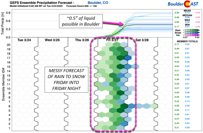
Detailed Forecast Discussion: As we mentioned in our weekly outlook, there were hints of a snow storm to affect the region on Friday. That has largely come true, along with the colder temperatures. Highs today will likely not rise much after a new batch of colder air works in through the day. Expect temperatures in the upper 30's to around …

BoulderCAST Daily – Thu 03/26/20 | Partly cloudy and 60’s today, rain/snow tomorrow

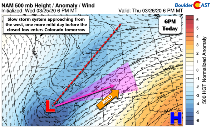
Detailed Forecast Discussion: A storm system sits over California this morning and is set to move into Utah tonight and then across northern Colorado tomorrow.  For today, we're looking at another period of strong southwest flow aloft associated with the subtropical jet stream. Despite some embedded moisture, general downslope flow will allow for partly to mostly sunny skies east of …

BoulderCAST Daily – Wed 03/25/20 | Gusty, but warm

Detailed Forecast Discussion: The NAM-NEST 500mb height and vorticity animation below shows the evolving atmosphere from this morning into Friday morning. Notice how very little the black height lines change/move across Colorado during the entire animation. We're stuck in the same flow pattern today as we saw yesterday and what we will experience tomorrow. This is a generally dry southwest …

« Older posts Newer posts »