⦁❶⦁ High pressure has pushed into California redirecting the thickest smoke northward into the Pacific Northwest
⦁❷⦁ One more day of moderately thick smoke is expected across the Front Range before we clear out considerably
⦁❸⦁ High temperatures near 90 degrees, but watch for isolated storms LATE tonight
⦁❹⦁ A slightly better chance of storms tomorrow, some of which could produce large hail
Do you want the latest BoulderCAST Daily forecast discussion delivered to your inbox every single morning? If so, join BoulderCAST Premium where we talk Boulder and Denver weather every single day.
Detailed Forecast Discussion:
One final day of thick smoke lies between us and marginally clearer skies and cleaner air tomorrow heading into the weekend! PM2.5 air quality remains on the poor side, though is notably better than any of the last four mornings. Air quality indices generally span from 80 to 110 across Front Range Colorado this morning.
High pressure continues to slowly intensify over northern California and the Great Basin area. Flow across our region is weak and out of the northwest. Embedded in this northwest flow is a shallow cold front tied to a disturbance in the Great Lakes. This front will move through during the morning hours leading to a slightly cooler day and also just a tad of low-level upslope. More on the impacts from this in a minute.
As you can see above, this pattern has redirected the plume of smoke coming off the big fires in California northward into Oregon and Washington. This is the view from GOES-West on Wednesday afternoon as the aforementioned high pressure sat directly over the fire zone. Notice the clockwise swirl of the smoke and the fact that it really wasn’t propagating far from the source due to the swirling, weak winds aloft.

GOES-West visible satellite animation of northern California from Wednesday afternoon showing the pooling smoke.
While this pattern shift is great news for Colorado in that the worst smoke will no longer be flowing directly our way, it also means the buck has been passed to other areas across the West, with isn’t good either. The TOTAL smoke forecast animation below spans through Saturday evening. Finally real improvement in the smoke is noted over the Front Range! However, look at the ominous pocket of smoke that develops to the west underneath that high pressure — it’s only a matter of time before that smoke blob will push back into Colorado.
For today, though, the weak morning cold front will usher in a little moisture at the surface along with upslope and a marginally cooler airmass. High temperatures today will fall a few degrees from yesterday. We’ll be around 90°F this afternoon. NowCAST shows the evolution through what will largely be another mostly sunny day. The only thing to watch is the potential for isolated thunderstorms to develop late tonight, mainly in the 8PM to 2AM timeframe.
ONLY the high-resolution model guidance has these storms, so confidence is low whether they will form or not and if they do, where they will pop across the Plains. The HRRR model simulated radar for this evening is shown below. This particular model run has the isolated storms developing near Greeley and also some near Limon tonight. Take this with a grain of salt, though. These storms could fire anywhere in the Front Range or not at all. We’ll put just a ~10% chance of storms in the forecast late this evening.
Tomorrow will offer similar temperatures with a better chance of storms as total layer moisture continues a slow climb.
We’re also going to need to watch for a few severe storms on Friday as well since instability will be increasing alongside minor levels of shear. The Storm Prediction Center currently has portions of northeast Colorado in the “Marginal” risk category for tomorrow, with 1″ hail the main thing to watch for. Storms on Friday will be tapping into deeper moisture, but nothing too bad. Moderate to heavy rainfall could accompany any storms, though motions should be fast enough to keep the risk of flash flooding in the burn scars rather low.
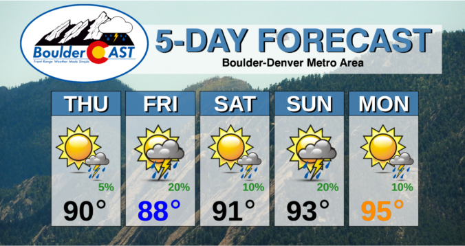
Here’s a look at the next five days. It’s good to see rain returning to the forecast, even at these low-end odds. We’ll take anything we can get!
Finally, we wanted to remind you again of the great resource available to you over on our Colorado Smoke Forecast page. We’ve recently added several NEW regions, a NEW model, NEW functionality to download GIFs for sharing, and a completely NEW look. Enjoy!
Remember, our daily forecasts are Premium content. Periodically, we open this forecast up to all of our readers. Today is one of those days!
Help support our team of Front Range weather bloggers by joining BoulderCAST Premium. We talk Boulder and Denver weather every single day. Sign up now to get access to our daily forecast discussions each morning, complete six-day skiing and hiking forecasts powered by machine learning, first-class access to all our Colorado-centric high-resolution weather graphics, bonus storm updates and much more! Or not, we just appreciate your readership!


You must be logged in to post a comment.