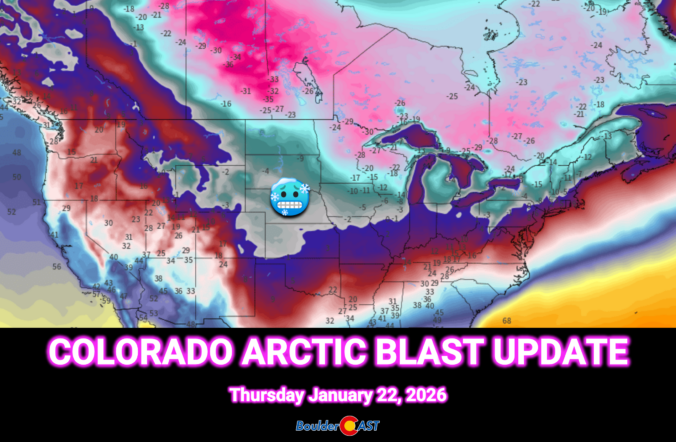
This weekend’s forecast looks nothing like the mild stretch we’ve been coasting through so far in 2026. A sharp pattern shake‑up is finally knocking on eastern Colorado’s door. An Arctic airmass is set to spill into the Front Range Thursday night, bringing the coldest temperatures of the season and eventually a round of light, fluffy snow. We break down the timing, impacts, and just how low those temperatures will go—plus why the rest of the country is gearing up for a far bigger and historic winter storm.
Author: BoulderCAST Team (Page 2 of 47)
This post had major contributions from at least two members of our team. The more meteorologists the better, right?
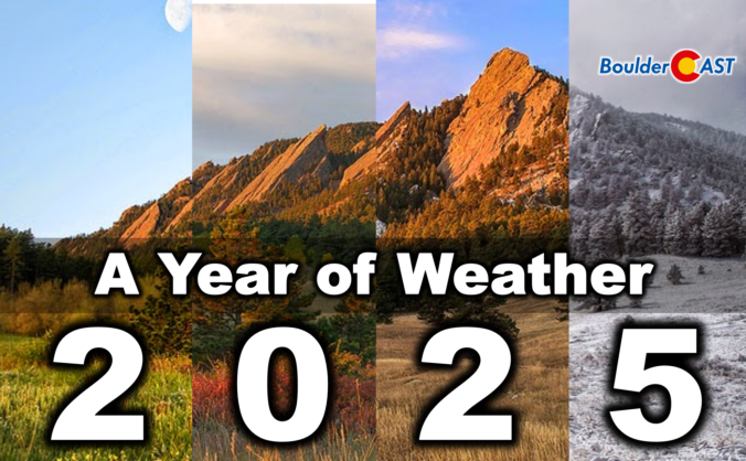
2025 was one of those years where Boulder’s weather never seemed content with a single storyline. We opened with a bitter Arctic punch that delivered our coldest January in nearly two decades, only to swing into a summer packed with 90°+ heat, smoky afternoons, and the hottest day since 2012. The monsoon showed up often but rarely with much enthusiasm, fall dried out in a hurry, and our first snow didn’t arrive until November 29th — the latest on record by a country mile. Now that the dust (and smoke, and snow) has settled, we’ve pulled together a full graphical recap of the temperature swings, precipitation quirks, record‑setting moments, and long‑term trends that defined Boulder’s and Colorado’s atmosphere in 2025. If you want the full story behind the chaos — and a clearer picture of where 2025 truly landed — this is a fun one to dive into. Be warned, there really are 100 charts and visuals to explore. Enjoy!
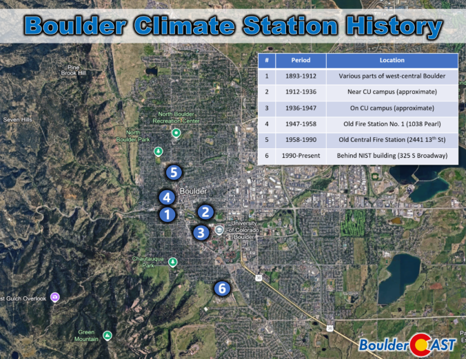
Boulder’s “official” climate record has never lived in one place for long. Over the past 130 years, the instruments that track our temperature, precipitation, and snowfall have been relocated again and again—sometimes only a few blocks, other times miles away into landscapes with completely different quirks and microclimates. Each move left its own imprint on the long‑term dataset we use today, subtly shaping how we compare modern conditions with the Boulder of decades past.
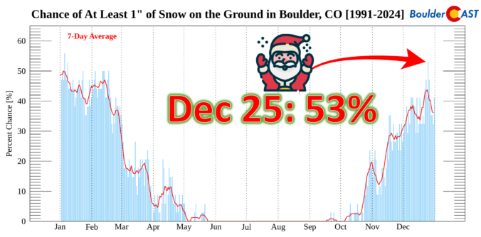
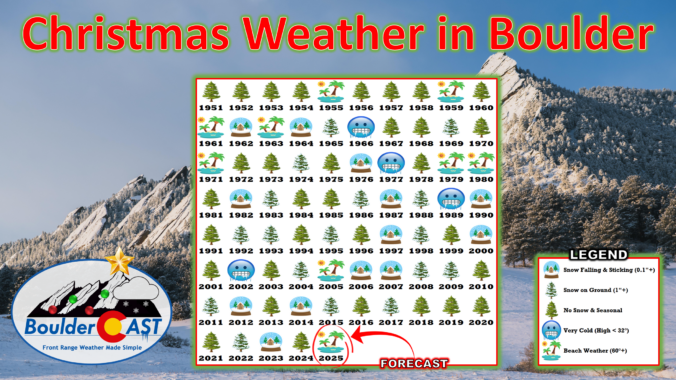
This Christmas will be a scorcher across the Front Range with temperatures soaring towards record highs near 70 degrees, but snow is often part of the equation here on Christmas, whether falling or on the ground. We take a broader look at White Christmas occurrences in Boulder’s historical record and discuss why Christmas Day, out of all days, has one of the highest probabilities of snow on the ground here.
December has been anything but typical along the Front Range, with Boulder shattering warmth records and enduring weeks of bone‑dry weather that have fueled fire danger and stressed our local trees. As we head into Christmas, the holiday will feel more like patio season than sledding weather, with record highs likely and no snow available outside of the Mountains. But don’t pack away the winter gear just yet—a sharp cooldown and even a chance for light snow are on the horizon this weekend. We take a closer look this historically warm and dry December, the scorching Christmas forecast, and peek ahead to what’s next.
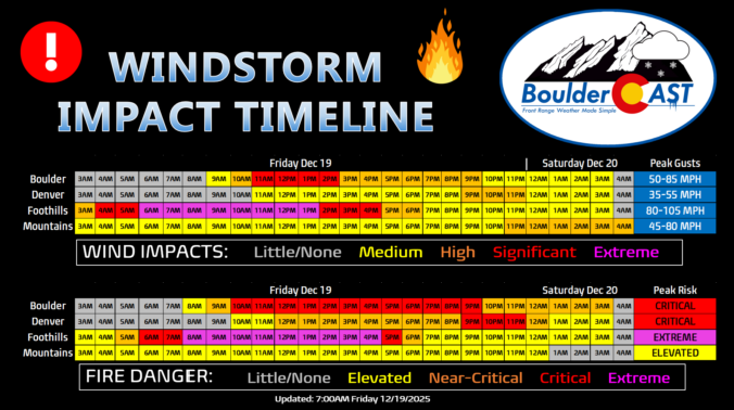
Updated (7AM Friday 12/19): Updated based on latest guidance adjusting timings and intensity of wind/fire impacts, and also made a stronger case for the extreme winds (and fire danger) to potentially stay mostly in the Foothills or very close to there. Lowered wind/fire risk in Boulder proper. This is still a very dangerous situation.
—
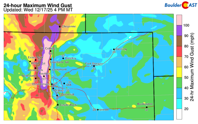
Boulder, the far western suburbs of Denver, and the Foothills are bracing for yet another powerful mountain wave windstorm Friday, with gusts likely topping 75–100 MPH and, this time, extreme fire danger will be layered on top. Forecast models show the strongest winds during the morning into the afternoon, coinciding with critically dry air and record‑challenging warmth. Power shutoffs, downed trees, and blowing dust are all on the table, but the bigger story is the fire risk—conditions are primed for rapid spread if any ignition occurs. Fortunately it now appears that most of the intense winds will stay largely in the Foothills, but there is some uncertainty how far downhill and east they will reach. Read on for the full breakdown of timing, impacts, and what you need to know to stay safe. We also briefly review the damaging wind event that just occurred on Wednesday.
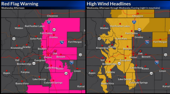
If you thought Monday’s sunshine was the start of a quiet week, think again. The next 48 hours will bring a dramatic shift in our weather —starting with breezy but pleasant conditions Tuesday, then escalating into a powerful downslope windstorm with heightened fire danger on Wednesday. And just when you think it’s wrapping up, a sharp cold front will crash the party with blustery conditions and even a chance for rain and snow Wednesday evening.
We’ll break down what to expect, where the strongest winds will hit, and how this event stacks up against the day of the Marshall Fire. Plus, we’ll look at the potential for Xcel power shutoffs (spoiler: it’s going to be happen).

Live View of Boulder

Current Conditions

Live Radar

Recent Premium Posts

BoulderCAST Daily – Wed 04/01/26 | The first day of April is showery, with even a few isolated storms
⛈️ Wednesday the 1st of April is showery: a shortwave brings scattered to …
BoulderCAST Daily – Tue 03/31/26 | The Great March 2026 heatwave is over with cooler, showery days ahead in the Front Range
🌬️ Heatwave broken: a pre‑dawn cold front will be keeping today’s highs near …
BoulderCAST Daily – Sun 03/29/26 | Staying warm prior to a cold front Tuesday
🔥 The low 80s continue through Monday, as ridge remains in place. 🌨️🌧️ …
3-Day Forecast

Trending Content

© 2026 Front Range Weather, LLC