


Author: Ben Castellani (Page 275 of 358)

Ben grew up in southwestern Pennsylvania and holds both a bachelor's and a master's degree in Meteorology, the latter being from CU Boulder. His hometown received nearly three feet of snow from the Storm of the Century back in March of 1993, sparking his initial interest in impactful weather. Ben currently works on remote sensing and data analysis software at NV5 Geospatial Software in Boulder.

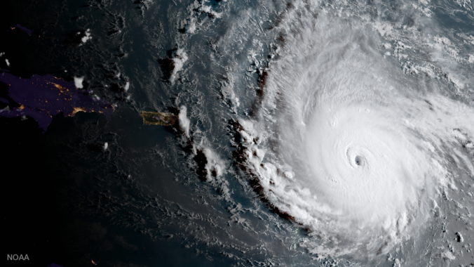
Hurricane Irma to make landfall in Florida?

As the nation braces for impact of another major tropical cyclone, we update you on the status of Hurricane Irma. Where is she headed and when will she arrive? Read on to find out.

DISCLAIMER: This update was created Wednesday, September 6, 2017. Any life-sustaining decisions regarding Irma should be made on your own accord following the most up to date guidance from the local emergency authorities. 
Continue reading

DayCAST: Wed 09/06/17

Beautiful weather will prevail once again today with mostly sunny skies and temperatures topping out near 80 degrees. Any precipitation will be spotty and confined to the southern half of the state (see map below). The main storyline will be the continued presence of smoke/haze across the region. Northwest flow in the mid and upper-levels of the atmosphere will limit …

DayCAST: Fri 09/01/17

Rain totals were less than impressive yesterday across the region with most locations seeing a few sprinkles up to only 0.05".  Nonetheless, as we mentioned for a while now, it was our best shot at rain for the week. August is now behind us. Below shows the summary of ups and downs from BoulderCAST Station for the month of August. …

DayCAST: Thu 08/31/17

Welcome to the last day of August and the official end of meteorological summer! The amount of leaves I have falling in my yard already is disgusting. The lack of recent rainfall and cooler than normal month of August is undoubtedly contributing. As we mentioned in our weekly outlook, today will offer the best chance of rain for the week …

DayCAST: Wed 08/30/17

Ridging remains strong across the region for at least one more day! Moisture will be slightly elevated compared to yesterday (this is about the only mention-able change in the atmospheric setup). With this, we expect to see a few more clouds and isolated to widely scattered storms develop this afternoon and evening. This will follow abundant morning sunshine. We're thinking …

DayCAST: Tue 08/29/17

Another warm day is expected across the Front Range as a dome of high pressure dominates our weather. Expect mostly sunny skies today with just a few isolated storms forming later this afternoon and evening. Just about everyone will remain dry, though. High temperatures will be in the lower 90's.

« Older posts Newer posts »
