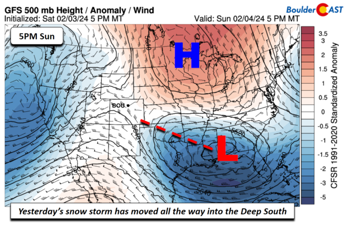
The first week of February starts off dry and mild as high pressure ridging and downslope flow will develop across the Front Range helping to chip away at the fresh, sloppy snowpack. A midweek system will favor mode cloud cover and winds, along with a low-end chance of rain or snow, though these will mostly be confined to the higher terrain. A better chance of snow and colder temperatures appears to come Friday or Saturday with most guidance suggesting a favorable storm track for our area. Read on as we discuss this and more in our weekly outlook.
Author: Andy (Page 56 of 221)
Born and raised in St. Louis, Andrew obtained a Ph.D. in Atmospheric Science from the University of Colorado in 2015. From 2015 to 2020, he worked remotely in Boulder as an atmospheric scientist with NOAA's Atlantic Oceanographic and Meteorological Laboratory in Miami. Andy is now a full-time meteorologist.

This week in the Front Range will be rather quiet and dry with most of the weather systems passing to our south. High temperatures will largely hover in the 40s throughout the extended — a very seasonal stretch indeed! There is some indication for a late-week snow chance but that is currently shaping up to be very minor at best. Let’s take a look…

Live View of Boulder

Current Conditions

Live Radar

Latest Smoke Forecast

Recent Premium Posts

BoulderCAST Daily – Fri 07/31/26 | Marginal Risk of Severe Storms with Smoke and Haze
🌧️ Isolated Storms — This afternoon and evening, with a marginal risk of …
BoulderCAST Daily – Wed 07/29/26 | Final Storm‑Filled Afternoon Before an Expanding Desert Southwest Heat Dome Takes Over
🌧️ Lingering Monsoon Moisture — Lingering Tap One last day of beneficial rainfall …
BoulderCAST Daily – Tue 07/28/26 | Front Range Primed for Widespread Thunderstorms as Monsoon Reloads
🌩️ Monsoon moisture surge — Deep moisture availability today, both aloft and at …
3-Day Forecast

Trending Content

© 2026 Front Range Weather, LLC